METAR & TAF 7L8
7L8 does not publish a METAR.
Showing the nearest reporting station: KMQJ (INDIANAPOLIS RGNL) · 7.7 NM away. Conditions at 7L8 may differ.
METAR · KMQJ
Observed 13:35Z
KMQJ 271335Z AUTO 00000KT 1 1/2SM BR OVC002 23/23 A2992 RMK AO2 T02300230 $
- Wind
- 000° @ 0 kt
- Visibility
- 0.5 SM
- Temp / Dew
- 23°C / 23°C
- Altimeter
- 29.92 inHg
- Clouds
- OVC
- Density alt
- 2,028 ft
- Ceiling
- 200 ft AGL
- Rules
- LIFR
Airport info & contacts
Manager on record, flight service, ARTCC, attendance schedule and pattern altitude — published by the FAA and refreshed every 28 days.
Location
- From city
- 6 NM E
- VFR sectional
- ST LOUIS
- ARTCC
- ZID · INDIANAPOLIS
- NOTAM facility
- HUF (NOTAM-D)
Airport manager
- Name
- MICHELLE FALL
- Phone
- 630-631-8787
- Address
- 1215 S. FRANKLIN RD., INDIANAPOLIS IN 46239
Flight service · Hours
- FSS HUF
- TERRE HAUTE1-800-WX-BRIEF
- Attendance
- IREG
Frequencies
Tap any row to copy the frequency to your clipboard.
Runways & pattern
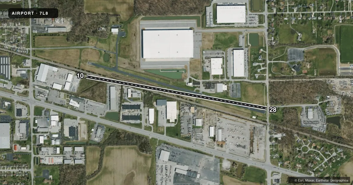
Full pagePattern entry · RWY 10
RIGHT TRAFFICRunway end performance
| End | TORA | TODA | ASDA | LDA | VGSI | Approach lights | Obstruction |
|---|---|---|---|---|---|---|---|
| 10 | — | — | — | — | — | — | 20', tree, 595' from thr, 175' R of cntrln, slope 19 |
| 28 | — | — | — | — | — | — | 45', trees, 201' from thr, 0' R of cntrln, slope 0 |
Declared distances in feet. TORA = takeoff run available, TODA = takeoff distance, ASDA = accelerate-stop, LDA = landing distance.
Airport sketch
Runways drawn to scale from FAA survey coordinates, rendered over satellite imagery. Not for navigation.
Approaches & charts
Services on the field
Fuel grades, oxygen, maintenance, ramp storage and lighting — as declared to the FAA by the airport operator.
Fuel & services
- Fuel
- Not available
Ramp & ground
- Transient storage
- Not published
- Lighting schedule
- SEE RMK
- Wind indicator
- Yes
- Segmented circle
- Yes
Fuel & FBOs
Cheapest 100LL and Jet A on the field and nearby. Always confirm with the FBO before taxi.
Airport notes
Surface conditions, obstructions, local procedures, lighting outages and other notes published with each FAA cycle.
General notes
- LGTD TV-TWR 2640'N OF APCH END RWY 28.
- FOR CD CTC INDIANAPOLIS APCH AT 317-227-5743.
Lighting notes
- FOR LIRL RY 10/28 - CTAF
Approach & departure obstructions
- 28HAS +25 FT PLINE; +15 FT ROAD; +25 FT HOUSE; 15-45 FT TREES 10-200 FT FM RWY END
- 28APCH SLOPE 5:1 DUE TO 20 FT BLD 100 FT FM DSPLCD THLD, 125 FT R
Other notes
- PRVDD RWY OBSTACLE FREE ZONE & 20:1 APP SFCS ARE MAINTD CLEAR.
VFR map & nearby airports
VFR sectional. Tap any ICAO chip to open that airport.
Key facts · 7L8
Answer card- ICAO
- 7L8
- Name
- POST-AIR
- Location
- INDIANAPOLIS, INDIANA
- Elevation
- 861 ft MSL
- Traffic pattern altitude
- 1,861 ft MSL (1,000 AGL)
- Control tower
- Non-towered (use CTAF)
- Total runways
- 1
- Longest runway
- 10/28 · 3,750 ft
- Published ILS approaches
- 0
- Published frequencies
- 1
- Magnetic variation
- 2°
- Current flight rules
- LIFR
- Current wind
- 000° at 0 kt
- Favored runway now
- –
POST-AIR sits in Indianapolis, Indiana. Field elevation is 861 ft MSL. The airport has one runway. Runway 10/28 is 3,750 ft of asphalt, which is the longest runway on the field. There is no control tower. CTAF is 122.9. No ILS approaches are published here.
Pattern altitude is not published. Use the standard 1,000 ft AGL for light piston traffic unless the current Chart Supplement says otherwise. For runway 28, plan around the published obstacle notes. There is a lighted television tower 2,640 feet north of the approach end. The remarks also call out a power line, road, house and trees near that end of the runway. The approach slope is noted as 5 to 1 because of a building near the displaced threshold. That makes a careful stabilized approach important.
There are no on-field FBOs listed in the facts. Contact the airport operator directly before arrival. Call the field on CTAF for current service availability. For clearance delivery, Indianapolis Approach is listed in the remarks. If you are planning a night arrival, use the runway lights on CTAF and verify current airport status before you go.