METAR & TAF KGFD
KGFD does not publish a METAR.
Showing the nearest reporting station: KMQJ (INDIANAPOLIS RGNL) · 8.1 NM away. Conditions at KGFD may differ.
METAR · KMQJ
Observed 12:35Z
KMQJ 271235Z AUTO 00000KT 1SM BR VV002 22/22 A2993 RMK AO2 T02200220 $
- Wind
- 000° @ 0 kt
- Visibility
- 1 SM
- Temp / Dew
- 22°C / 22°C
- Altimeter
- 29.93 inHg
- Clouds
- VV
- Density alt
- 1,937 ft
- Ceiling
- 200 ft AGL
- Rules
- LIFR
Airport info & contacts
Manager on record, flight service, ARTCC, attendance schedule and pattern altitude — published by the FAA and refreshed every 28 days.
Location
- From city
- 2 NM NE
- VFR sectional
- ST LOUIS
- ARTCC
- ZID · INDIANAPOLIS
- NOTAM facility
- HUF (NOTAM-D)
Airport manager
- Name
- LISA NEILL
- Phone
- 317-467-9740
- Address
- PO BOX 333, GREENFIELD IN 46140
Flight service · Hours
- FSS HUF
- TERRE HAUTE1-800-WX-BRIEF
- Attendance
- Unattended
Frequencies
Tap any row to copy the frequency to your clipboard.
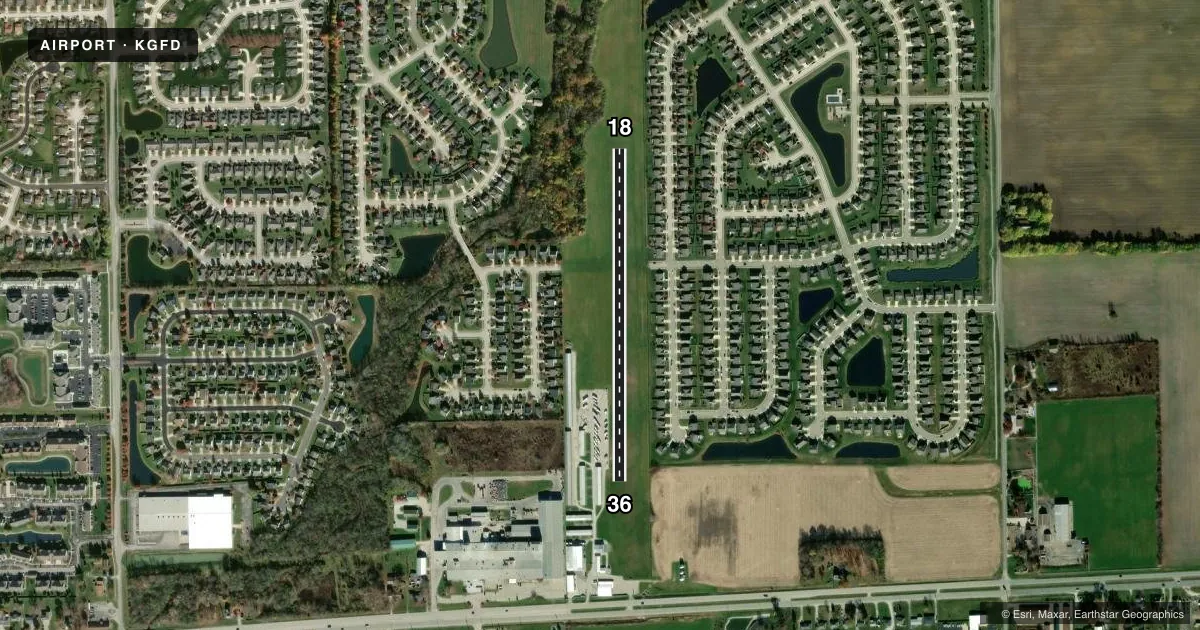
Runways & pattern
Full pagePattern entry · RWY 18
LEFT TRAFFICRunway end performance
| End | TORA | TODA | ASDA | LDA | VGSI | Approach lights | Obstruction |
|---|---|---|---|---|---|---|---|
| 18 | — | — | — | — | — | — | 70', trees, 155' from thr, 140' R of cntrln, slope 2 |
| 36 | — | — | — | — | — | — | 30', pole, 225' from thr, 140' R of cntrln, slope 7 |
Declared distances in feet. TORA = takeoff run available, TODA = takeoff distance, ASDA = accelerate-stop, LDA = landing distance.
Airport sketch
Runways drawn to scale from FAA survey coordinates, rendered over satellite imagery. Not for navigation.
Approaches & charts
Services on the field
Fuel grades, oxygen, maintenance, ramp storage and lighting — as declared to the FAA by the airport operator.
Fuel & services
- Fuel
- Not available
- Oxygen (bottled)
- Not available
- Oxygen (bulk)
- Not available
Ramp & ground
- Transient storage
- Tie-down
- Hangar
- Landing fee
- No fee published
- Customs
- Not available
- Wind indicator
- Yes
- Segmented circle
- No
Fuel & FBOs
Cheapest 100LL and Jet A on the field and nearby. Always confirm with the FBO before taxi.
Airport notes
Surface conditions, obstructions, local procedures, lighting outages and other notes published with each FAA cycle.
General notes
- FOR CD CTC INDIANAPOLIS APCH AT 317-227-5743.
Runway surface & condition
- 18/36CROPS 55 FT N OF RWY 18 DSPLCD THR & 75 FT E & W OF RWY CNTRLN.
Approach & departure obstructions
- 18DSPLCD THR MKD WITH INOP RWY LGTS.
- 1870 FT TREES 320 FT FM RWY END 150 FT R; APCH RATIO 4:1 AT DSPLCD THR.
VFR map & nearby airports
VFR sectional. Tap any ICAO chip to open that airport.
Key facts · KGFD
Answer card- ICAO
- KGFD
- Name
- POPE FLD
- Location
- GREENFIELD, INDIANA
- Elevation
- 895 ft MSL
- Traffic pattern altitude
- 1,895 ft MSL (1,000 AGL)
- Control tower
- Non-towered (use CTAF)
- Total runways
- 1
- Longest runway
- 18/36 · 2,165 ft
- Published ILS approaches
- 0
- Published frequencies
- 1
- Magnetic variation
- 2°
- Current flight rules
- LIFR
- Current wind
- 000° at 0 kt
- Favored runway now
- –
POPE FLD sits in Greenfield, Indiana. The field elevation is 895 ft MSL. It has one runway. The longest is 18/36 at 2,165 ft on turf. There is no control tower. CTAF is 122.9.
No ILS approaches are published here. The pattern altitude is not published. Use the standard 1,000 ft AGL unless the current Chart Supplement says otherwise. That puts the traffic pattern at 1,895 ft MSL based on the field elevation, but verify the published pattern before you go. Clearance delivery is handled through Indianapolis Approach at 317-227-5743.
The runway environment needs a close look before arrival. Runway 18 has a displaced threshold. The published remarks also call out inoperative runway lights at that threshold. There are 70-foot trees near the 18 end. Crops are also noted near the runway area. That makes the approach and departure picture more important than the short runway length alone. There are no on-field FBOs listed, so plan to coordinate with the airport operator or call ahead for current services and fuel availability.