METAR & TAF I80
I80 does not publish a METAR.
Showing the nearest reporting station: KUMP (INDIANAPOLIS METRO) · 5.5 NM away. Conditions at I80 may differ.
METAR · KUMP
Observed 03:55Z
KUMP 250355Z AUTO 00000KT 10SM CLR 17/16 A3011 RMK AO2 T01690157 $
- Wind
- 000° @ 0 kt
- Visibility
- 10 SM
- Temp / Dew
- 17°C / 16°C
- Altimeter
- 30.11 inHg
- Clouds
- CLR
- Density alt
- 1,034 ft
- Ceiling
- Unlimited
- Rules
- VFR
Airport info & contacts
Manager on record, flight service, ARTCC, attendance schedule and pattern altitude — published by the FAA and refreshed every 28 days.
Location
- From city
- 4 NM SE
- VFR sectional
- CHICAGO
- ARTCC
- ZID · INDIANAPOLIS
- NOTAM facility
- HUF (NOTAM-D)
Airport manager
- Name
- DON ROBERTS/LARRY JACOBI
- Phone
- 317-773-3112
- Address
- 14782 PROMISE ROAD, NOBLESVILLE IN 46060
Flight service · Hours
- FSS HUF
- TERRE HAUTE1-800-WX-BRIEF
- Attendance
- Unattended
Frequencies
Tap any row to copy the frequency to your clipboard.
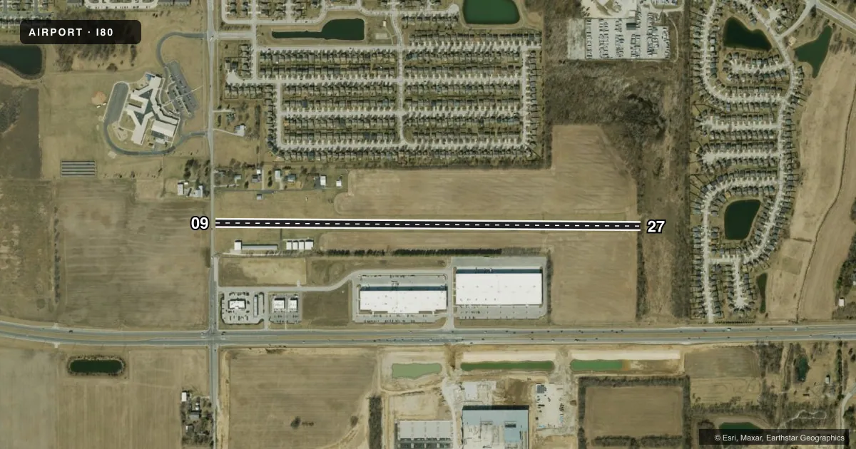
Runways & pattern
Full pagePattern entry · RWY 09
RIGHT TRAFFICRunway end performance
| End | TORA | TODA | ASDA | LDA | VGSI | Approach lights | Obstruction |
|---|---|---|---|---|---|---|---|
| 09 | — | — | — | — | — | — | 15', road, 0' from thr, 0' R of cntrln, slope 0 |
| 27 | — | — | — | — | — | — | 30', tree, 120' from thr, 110' R of cntrln, slope 4 |
Declared distances in feet. TORA = takeoff run available, TODA = takeoff distance, ASDA = accelerate-stop, LDA = landing distance.
Airport sketch
Runways drawn to scale from FAA survey coordinates, rendered over satellite imagery. Not for navigation.
Approaches & charts
Services on the field
Fuel grades, oxygen, maintenance, ramp storage and lighting — as declared to the FAA by the airport operator.
Fuel & services
- Fuel
- Not available
Ramp & ground
- Transient storage
- Tie-down
- Hangar
- Lighting schedule
- SEE RMK
- Wind indicator
- Yes
- Segmented circle
- Yes
Fuel & FBOs
Cheapest 100LL and Jet A on the field and nearby. Always confirm with the FBO before taxi.
Airport notes
Surface conditions, obstructions, local procedures, lighting outages and other notes published with each FAA cycle.
General notes
- FOR CD CTC INDIANAPOLIS APCH AT 317-227-5743.
Lighting notes
- ACTVT LIRL RY 09/27 - 122.7
Runway surface & condition
- 09/27RY 09/27 NO LIGHTS BTN RY ENDS AND DSPLCD THLDS.
Approach & departure obstructions
- 09RY 09 APCH SLOPE 31:1 AT DSPLCD THLD.
Other notes
- MANAGERLARRYJACOBI@SBCGLOBAL.NET
VFR map & nearby airports
VFR sectional. Tap any ICAO chip to open that airport.
Key facts · I80
Answer card- ICAO
- I80
- Name
- NOBLESVILLE
- Location
- NOBLESVILLE, INDIANA
- Elevation
- 830 ft MSL
- Traffic pattern altitude
- 1,830 ft MSL (1,000 AGL)
- Control tower
- Non-towered (use CTAF)
- Total runways
- 1
- Longest runway
- 09/27 · 3,580 ft
- Published ILS approaches
- 0
- Published frequencies
- 1
- Magnetic variation
- 2°
- Current flight rules
- VFR
- Current wind
- 000° at 0 kt
- Favored runway now
- –
Noblesville Airport (I80) sits in Noblesville, Indiana. The field elevation is 830 ft MSL. It has one runway. Runway 09/27 is 3,580 ft of turf, which is the longest runway on the field.
This is an uncontrolled airport. There is no control tower. CTAF is 122.9. No ILS approaches are published. The pattern altitude is not published in the facts, so verify the current Chart Supplement before you fly. The runway headings are magnetic. Runway 09 is 090° magnetic. Runway 27 is 270° magnetic.
The published remarks matter here. Runway 09/27 has no lights between the runway ends and displaced thresholds. Low intensity runway lights are activated on 122.7. Runway 09 also has a steep approach slope note at the displaced threshold. If you are planning a night arrival or a first visit, check the current Chart Supplement and brief the runway carefully. There are no on-field FBOs listed in the facts. Contact the airport operator directly before arrival, or call the field on CTAF for current service information. For clearance delivery, Indianapolis Approach is the published contact.