METAR & TAF 5I4
5I4 does not publish a METAR.
Showing the nearest reporting station: KTYQ (INDIANAPOLIS EXEC) · 9.1 NM away. Conditions at 5I4 may differ.
METAR · KTYQ
Observed 18:15Z
KTYQ 261815Z AUTO 00000KT 10SM CLR 28/20 A2996 RMK AO2 T02780202
- Wind
- 000° @ 0 kt
- Visibility
- 10 SM
- Temp / Dew
- 28°C / 20°C
- Altimeter
- 29.96 inHg
- Clouds
- CLR
- Density alt
- 2,671 ft
- Ceiling
- Unlimited
- Rules
- VFR
Airport info & contacts
Manager on record, flight service, ARTCC, attendance schedule and pattern altitude — published by the FAA and refreshed every 28 days.
Location
- From city
- 3 NM N
- VFR sectional
- CHICAGO
- ARTCC
- ZID · INDIANAPOLIS
- NOTAM facility
- HUF (NOTAM-D)
Airport manager
- Name
- SAM SACHS
- Phone
- 317-385-3015
- Address
- 27045 JERKWATER ROAD, SHERIDAN IN 46069
Flight service · Hours
- FSS HUF
- TERRE HAUTE1-800-WX-BRIEF
- Attendance
- 0800-1800
Frequencies
Tap any row to copy the frequency to your clipboard.
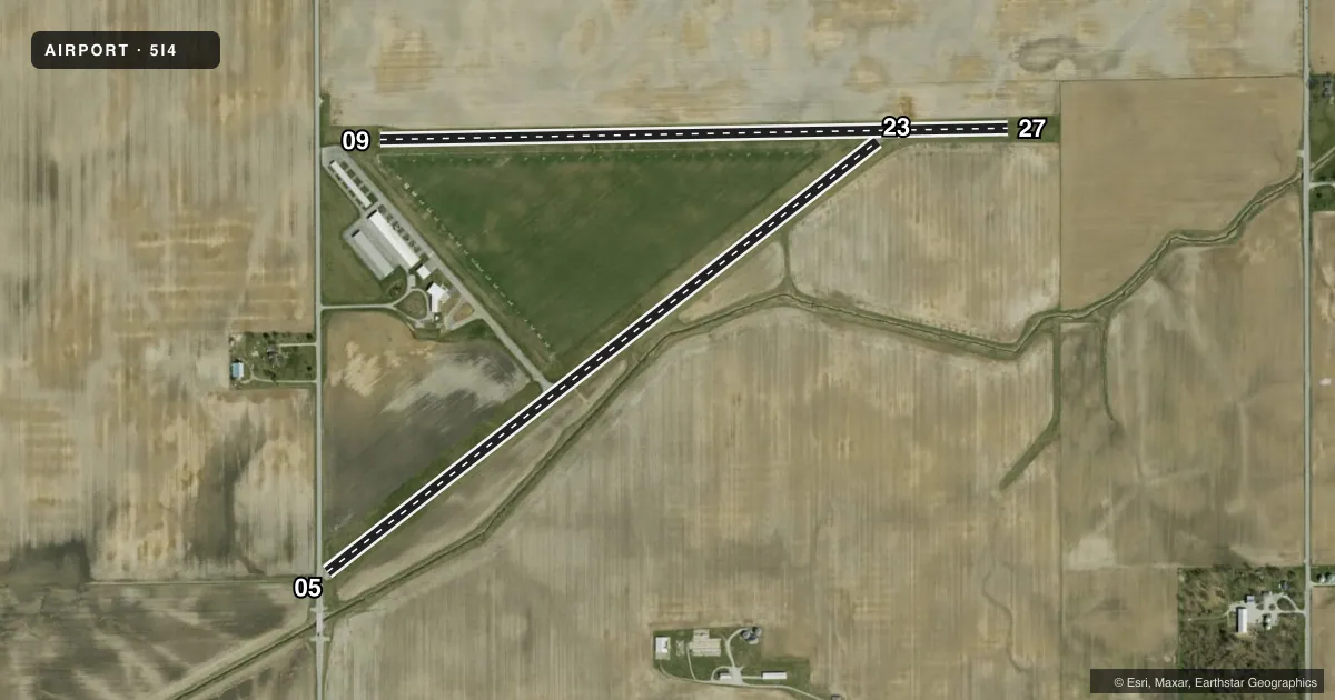
Runways & pattern
Full pagePattern entry · RWY 05
LEFT TRAFFIC| Runway | Heading (°M) | Length | Surface | Traffic |
|---|---|---|---|---|
| 05/23 | 52° / 232° | 3,760 ft | ASPH | Standard L |
| 09/27 | 88° / 268° | 3,387 ft | TURF | Standard L |
Runway end performance
| End | TORA | TODA | ASDA | LDA | VGSI | Approach lights | Obstruction |
|---|---|---|---|---|---|---|---|
| 05 | — | — | — | — | — | — | 10', crops, 201' from thr, 0' R of cntrln, slope 1 |
| 23 | — | — | — | — | TRIL | — | 10', crops, 201' from thr, 0' R of cntrln, slope 1 |
| 09 | — | — | — | — | — | — | 18', bldg, 280' from thr, 125' R of cntrln, slope 15 |
| 27 | — | — | — | — | — | — | 10', crops, 5' from thr, 0' R of cntrln, slope 0 |
Declared distances in feet. TORA = takeoff run available, TODA = takeoff distance, ASDA = accelerate-stop, LDA = landing distance.
Airport sketch
Runways drawn to scale from FAA survey coordinates, rendered over satellite imagery. Not for navigation.
Approaches & charts
Services on the field
Fuel grades, oxygen, maintenance, ramp storage and lighting — as declared to the FAA by the airport operator.
Fuel & services
- Fuel
- 100LL
- Oxygen (bottled)
- Not available
- Oxygen (bulk)
- Not available
- Airframe repair
- Major
- Power plant repair
- Major
- Other services
- INSTR,RNTL
Ramp & ground
- Transient storage
- Tie-down
- Hangar
- Landing fee
- No fee published
- Customs
- Not available
- Lighting schedule
- SEE RMK
- Beacon schedule
- SEE RMK
- Beacon
- White / Green (civil land)(WG)
- Wind indicator
- Yes
- Segmented circle
- No
Fuel & FBOs
Cheapest 100LL and Jet A on the field and nearby. Always confirm with the FBO before taxi.
Airport notes
Surface conditions, obstructions, local procedures, lighting outages and other notes published with each FAA cycle.
General notes
- DURG WINTER MONTHS CALL AMGR TO VFY RWY CONDS - 317-385-3015.
- FOR CD CTC INDIANAPOLIS APCH AT 317-227-5743.
- BIRDS ON & INVOF ARPT
Lighting notes
- PHONE REQ
- ACTVT NSTD LIRL RY 05/23 - CTAF.
Runway surface & condition
- 09/27HAS A 325 FT STWY WEST END.
- 05/23NSTD; RY 23 NSTD THLD LGTS
Approach & departure obstructions
- 05RWY 05 RD 15' FRM END, CROPS 50' FM RWY END.
- 05RWY 05 APCH RATIO 22:1 TO DSPLCD THLD.
- 27APCH RATIO 21:1 TO DSPLCD THLD.
Other notes
- THIS AIRPORT HAS BEEN SURVEYED BY THE NATIONAL GEODETIC SURVEY.
- EXISTED PRIOR TO 1959.
VFR map & nearby airports
VFR sectional. Tap any ICAO chip to open that airport.
Key facts · 5I4
Answer card- ICAO
- 5I4
- Name
- SHERIDAN
- Location
- SHERIDAN, INDIANA
- Elevation
- 936 ft MSL
- Traffic pattern altitude
- 1,936 ft MSL (1,000 AGL)
- Control tower
- Non-towered (use CTAF)
- Total runways
- 2
- Longest runway
- 05/23 · 3,760 ft
- Published ILS approaches
- 0
- Published frequencies
- 4
- Magnetic variation
- 0°
- Current flight rules
- VFR
- Current wind
- 000° at 0 kt
- Favored runway now
- –
Sheridan Airport (5I4) is in Sheridan, Indiana. Field elevation is 936 ft MSL. The airport has two runways. The longest is runway 05/23 at 3,760 ft. Runway 09/27 is turf and measures 3,387 ft. There is no control tower. CTAF and UNICOM are both 123.075. Approach and departure service is handled by Indianapolis Approach on 124.65 and 317.8.
No ILS approaches are published here. Pattern altitude is not published in the Chart Supplement. Use the standard 1,000 ft AGL for light piston traffic unless local procedures say otherwise. Sheridan Airport has one on-field FBO. Sheridan Airport carries 100LL. Call (317) 385-3015 for current service details.
A few published remarks matter for planning. Runway 05 has a displaced threshold with an approach slope note. There is a road close to the end of runway 05. Crops are also noted near that end. Runway 27 has a displaced threshold note. Runway 09/27 has a 325 ft stopway on the west end. The airport also uses nonstandard low intensity lights on 05/23. Those lights are controlled by CTAF. Beacon lighting requires a phone call. Birds have been reported on and near the airport. In winter, call the airport manager at the listed number to verify runway conditions before you go.