METAR & TAF 8I3
8I3 does not publish a METAR.
Showing the nearest reporting station: KOKK (KOKOMO MUNI) · 8.7 NM away. Conditions at 8I3 may differ.
METAR · KOKK
Observed 17:56Z
KOKK 261756Z AUTO 15004KT 10SM SCT026 27/21 A2996 RMK AO2 SLP139 T02670211 10278 20206 58007 $
- Wind
- 150° @ 4 kt
- Visibility
- 10 SM
- Temp / Dew
- 27°C / 21°C
- Altimeter
- 29.96 inHg
- Clouds
- SCT
- Density alt
- 2,444 ft
- Ceiling
- Unlimited
- Rules
- VFR
Airport info & contacts
Manager on record, flight service, ARTCC, attendance schedule and pattern altitude — published by the FAA and refreshed every 28 days.
Location
- From city
- 5 NM SW
- VFR sectional
- CHICAGO
- ARTCC
- ZAU · CHICAGO
- NOTAM facility
- HUF (NOTAM-D)
Airport manager
- Name
- DAWN BRIER
- Phone
- 765-878-4035
- Address
- 3460 S 400 W, KOKOMO IN 46902
Flight service · Hours
- FSS HUF
- TERRE HAUTE1-800-WX-BRIEF
- Attendance
- MON-FRI · DALGT
Frequencies
Tap any row to copy the frequency to your clipboard.
Runways & pattern
Full pagePattern entry · RWY 18
LEFT TRAFFICRunway end performance
| End | TORA | TODA | ASDA | LDA | VGSI | Approach lights | Obstruction |
|---|---|---|---|---|---|---|---|
| 18 | — | — | — | — | — | — | 60', pline, 875' from thr, 0' R of cntrln, slope 14 |
| 36 | — | — | — | — | — | — | 15', road, 40' from thr, 0' R of cntrln, slope 2 |
Declared distances in feet. TORA = takeoff run available, TODA = takeoff distance, ASDA = accelerate-stop, LDA = landing distance.
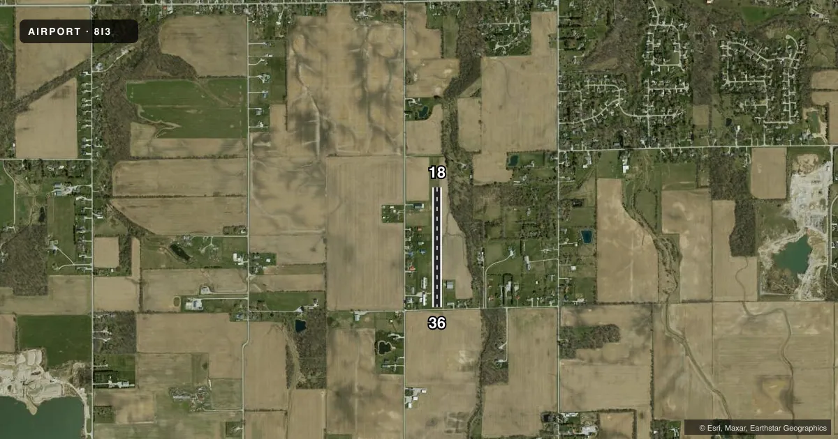
Airport sketch
Runways drawn to scale from FAA survey coordinates, rendered over satellite imagery. Not for navigation.
Approaches & charts
Services on the field
Fuel grades, oxygen, maintenance, ramp storage and lighting — as declared to the FAA by the airport operator.
Fuel & services
- Fuel
- Not available
- Airframe repair
- Not available
- Power plant repair
- Not available
Ramp & ground
- Transient storage
- Tie-down
- Landing fee
- No fee published
- Wind indicator
- Yes
- Segmented circle
- No
Fuel & FBOs
Cheapest 100LL and Jet A on the field and nearby. Always confirm with the FBO before taxi.
Airport notes
Surface conditions, obstructions, local procedures, lighting outages and other notes published with each FAA cycle.
General notes
- FOR CD CTC CHICAGO ARTCC AT 630-906-8921.
Runway surface & condition
- 18/36500 FT STWY N END.
- 18/36CROPS 55 FT L & R OF CNTRLN WHOLE LEN.
Approach & departure obstructions
- 18DTHR MKD WITH YELLOW METAL MARKERS.
- 36DTHR MKD WITH YELLOW METAL MARKERS.
- 18APCH RATIO 21:1 TO DSPLCD THR.
- 36APCH RATIO 20:1 TO DSPLCD THR.
- 18OBSTN MRKD W/ORANGE BALLS.
VFR map & nearby airports
VFR sectional. Tap any ICAO chip to open that airport.
Key facts · 8I3
Answer card- ICAO
- 8I3
- Name
- GLENNDALE
- Location
- KOKOMO, INDIANA
- Elevation
- 850 ft MSL
- Traffic pattern altitude
- 1,850 ft MSL (1,000 AGL)
- Control tower
- Non-towered (use CTAF)
- Total runways
- 1
- Longest runway
- 18/36 · 2,048 ft
- Published ILS approaches
- 0
- Published frequencies
- 1
- Magnetic variation
- 2°
- Current flight rules
- VFR
- Current wind
- 150° at 4 kt
- Favored runway now
- RWY 18
GlennDale Airport (8I3) is in Kokomo, Indiana. The field elevation is 850 ft MSL. It has one runway. Runway 18/36 is 2,048 ft of turf, which makes it a short-field stop for light piston traffic. There is no control tower. CTAF is 122.9.
No ILS approaches are published here. Pattern altitude is not published, so use the standard 1,000 ft AGL pattern unless the current Chart Supplement says otherwise. That puts the pattern at 1,850 ft MSL based on the field elevation. The published remarks matter here. Runway 18 has orange ball-marked obstructions. The displaced thresholds on both ends are marked with yellow metal markers. Crops extend 55 feet left and right of the centerline along the full length of the runway. There is also a 500 foot stopway at the north end.
There are no on-field FBOs listed. Plan fuel and ground support with the airport operator or the FBO directly by phone before you go. For clearance delivery, contact Chicago ARTCC at 630-906-8921. First-time pilots should pay close attention to the turf surface. Also watch the short runway length and the displaced thresholds. Verify current field conditions before departure, especially after rain or during crop growth.