METAR & TAF 5I2
5I2 does not publish a METAR.
Showing the nearest reporting station: KGGP (LOGANSPORT/CASS COUNTY) · 13.0 NM away. Conditions at 5I2 may differ.
METAR · KGGP
Observed 11:17Z
KGGP 271117Z AUTO RMK AO2 PWINO
- Wind
- Calm
- Visibility
- —
- Temp / Dew
- —
- Altimeter
- —
- Clouds
- Clear
- Density alt
- —
- Ceiling
- Unlimited
- Rules
- VFR
Airport info & contacts
Manager on record, flight service, ARTCC, attendance schedule and pattern altitude — published by the FAA and refreshed every 28 days.
Location
- From city
- 2 NM SW
- VFR sectional
- CHICAGO
- ARTCC
- ZAU · CHICAGO
- NOTAM facility
- HUF (NOTAM-D)
Airport manager
- Name
- JACK BEGLEY
- Phone
- (574) 967-4844
- Address
- 4 EAST MAIN ST, FLORA IN 46929
Flight service · Hours
- FSS HUF
- TERRE HAUTE1-800-WX-BRIEF
- Attendance
- Unattended
Frequencies
Tap any row to copy the frequency to your clipboard.
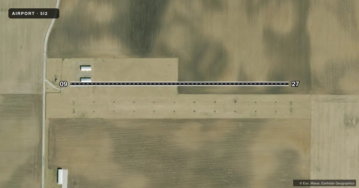
Runways & pattern
Full pagePattern entry · RWY 09
LEFT TRAFFICRunway end performance
| End | TORA | TODA | ASDA | LDA | VGSI | Approach lights | Obstruction |
|---|---|---|---|---|---|---|---|
| 09 | — | — | — | — | — | — | 15', road, 285' from thr, 0' R of cntrln, slope 20 |
| 27 | — | — | — | — | — | — | 10', crops, 200' from thr, 0' R of cntrln, slope 20 |
Declared distances in feet. TORA = takeoff run available, TODA = takeoff distance, ASDA = accelerate-stop, LDA = landing distance.
Airport sketch
Runways drawn to scale from FAA survey coordinates, rendered over satellite imagery. Not for navigation.
Approaches & charts
Services on the field
Fuel grades, oxygen, maintenance, ramp storage and lighting — as declared to the FAA by the airport operator.
Fuel & services
- Fuel
- Not available
- Oxygen (bottled)
- Not available
- Oxygen (bulk)
- Not available
- Airframe repair
- Not available
- Power plant repair
- Not available
Ramp & ground
- Transient storage
- Tie-down
- Landing fee
- No fee published
- Customs
- Not available
- Lighting schedule
- SS-SR
- Wind indicator
- Lighted
- Segmented circle
- No
Fuel & FBOs
Cheapest 100LL and Jet A on the field and nearby. Always confirm with the FBO before taxi.
Airport notes
Surface conditions, obstructions, local procedures, lighting outages and other notes published with each FAA cycle.
General notes
- FOR CD CTC CHICAGO ARTCC AT 630-906-8921.
VFR map & nearby airports
VFR sectional. Tap any ICAO chip to open that airport.
Key facts · 5I2
Answer card- ICAO
- 5I2
- Name
- FLORA MUNI
- Location
- FLORA, INDIANA
- Elevation
- 710 ft MSL
- Traffic pattern altitude
- 1,710 ft MSL (1,000 AGL)
- Control tower
- Non-towered (use CTAF)
- Total runways
- 1
- Longest runway
- 09/27 · 2,143 ft
- Published ILS approaches
- 0
- Published frequencies
- 1
- Magnetic variation
- 2°
- Current flight rules
- VFR
- Current wind
- Calm / unavailable
- Favored runway now
- –
Flora Muni sits in Flora, Indiana at 710 ft MSL. It has one runway. Runway 09/27 is 2,143 ft of turf, so plan for soft-field technique and check the surface condition before you go. The field is non-towered. CTAF is 122.9. No ILS approaches are published here.
Pattern altitude is not published. Use the standard 1,000 ft AGL for light piston traffic unless the current FAA Chart Supplement says otherwise. With a field elevation of 710 ft MSL, that puts a typical pattern near 1,710 ft MSL. The published remarks say to contact Chicago ARTCC at 630-906-8921 for clearance delivery. That is useful if you need IFR handling before departure.
There are no on-field FBOs listed in the facts. Plan on bringing what you need with you. Verify current services with the airport operator before arrival. For a first-time visit, the main things to watch are the turf surface, the short runway length and the lack of published instrument approaches. Check the current Chart Supplement for any local notes before flying in.