METAR & TAF KFKR
Current METAR
Observed 06:15Z
KFKR 260615Z AUTO 00000KT 10SM OVC009 20/21 A2998 RMK AO2
- Wind
- 000° @ 0 kt
- Visibility
- 10 SM
- Temp / Dew
- 20°C / 21°C
- Altimeter
- 29.98 inHg
- Clouds
- OVC
- Density alt
- 1,593 ft
- Ceiling
- 900 ft AGL
- Rules
- IFR
Airport info & contacts
Manager on record, flight service, ARTCC, attendance schedule and pattern altitude — published by the FAA and refreshed every 28 days.
Location
- From city
- 3 NM W
- VFR sectional
- CHICAGO
- ARTCC
- ZAU · CHICAGO
- NOTAM facility
- HUF (NOTAM-D)
Airport manager
- Name
- NICK RASMUSSEN
- Phone
- 765-654-6275
- Address
- 3009 W STATE ROAD 28, FRANKFORT IN 46041
Flight service · Hours
- FSS HUF
- TERRE HAUTE1-800-WX-BRIEF
- Attendance
- 0800-1700
Frequencies
Tap any row to copy the frequency to your clipboard.
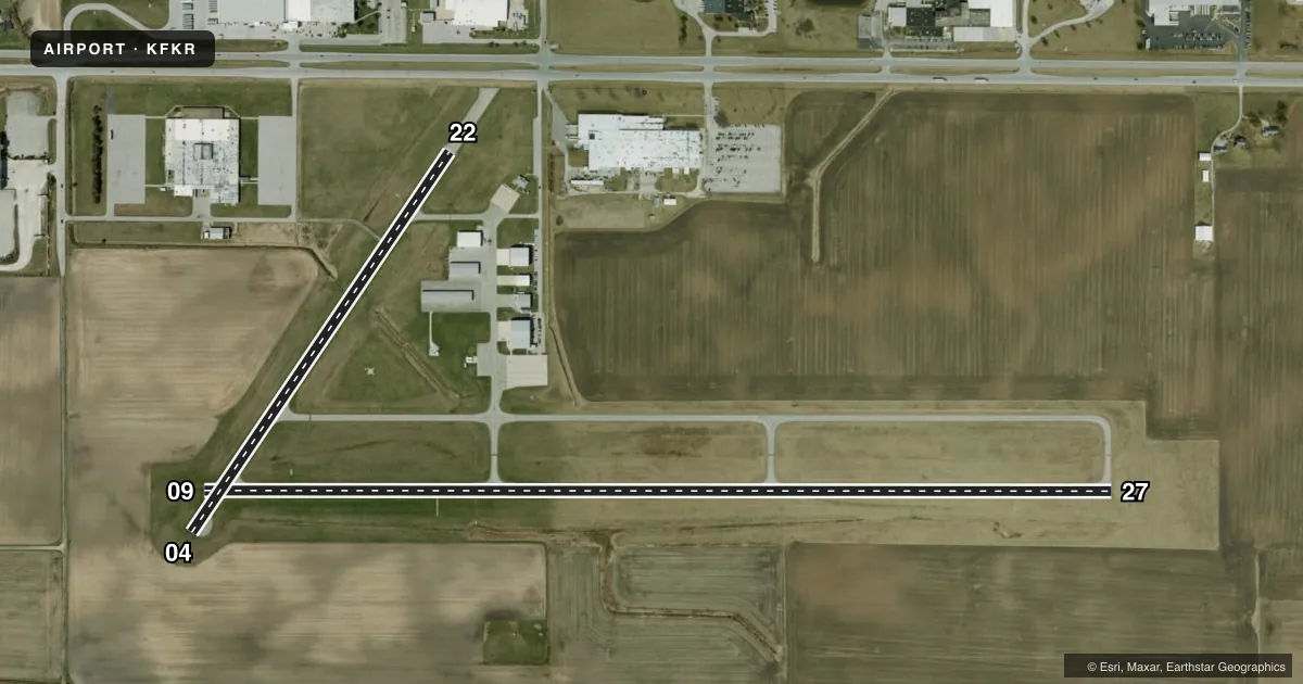
Runways & pattern
Full pagePattern entry · RWY 09
LEFT TRAFFIC| Runway | Heading (°M) | Length | Surface | Traffic |
|---|---|---|---|---|
| 09/27 | 88° / 268° | 5,000 ft | ASPH | Standard L |
| 04/22 | 32° / 212° | 2,527 ft | ASPH | Standard L |
Runway end performance
| End | TORA | TODA | ASDA | LDA | VGSI | Approach lights | Obstruction |
|---|---|---|---|---|---|---|---|
| 09 | — | — | — | — | PAPI 2-box left(3°) | — | 10', crops, 300' from thr, 0' R of cntrln, slope 10 |
| 27 | — | — | — | — | PAPI 2-box left(3°) | — | — |
| 04 | — | — | — | — | — | — | 10', crops, 206' from thr, 0' R of cntrln, slope 0 |
| 22 | — | — | — | — | PAPI 2-box right(4°) | — | 19', road, 370' from thr, 140' R of cntrln, slope 8 |
Declared distances in feet. TORA = takeoff run available, TODA = takeoff distance, ASDA = accelerate-stop, LDA = landing distance.
Airport sketch
Runways drawn to scale from FAA survey coordinates, rendered over satellite imagery. Not for navigation.
Approaches & charts
Services on the field
Fuel grades, oxygen, maintenance, ramp storage and lighting — as declared to the FAA by the airport operator.
Fuel & services
- Fuel
- 100LLA
- Airframe repair
- Minor
- Power plant repair
- Minor
- Other services
- AGRI,CHTR,INSTR,PAJA,RNTL
Ramp & ground
- Transient storage
- Tie-down
- Hangar
- Landing fee
- No fee published
- Customs
- Not available
- Lighting schedule
- SEE RMK
- Beacon schedule
- SS-SR
- Beacon
- White / Green (civil land)(WG)
- Wind indicator
- Lighted
- Segmented circle
- No
Fuel & FBOs
Cheapest 100LL and Jet A on the field and nearby. Always confirm with the FBO before taxi.
Airport notes
Surface conditions, obstructions, local procedures, lighting outages and other notes published with each FAA cycle.
General notes
- FOR CD CTC CHICAGO ARTCC AT 630-906-8921.
- COYOTE ON & INVOF ARPT.
Lighting notes
- ACTVT REIL RWY 09 & 27; MIRL RWY 04/22 & 09/27 - CTAF. MIRL RWY 04/22 & 09/27 PRESET LOW INTST; INCR INTST - CTAF.
Runway surface & condition
- 04/22420 FT SWY NE END. 20 FT WIDE DITCH PERPENDICULAR TO RWY 100 FT W OF CNTRLN.
Approach & departure obstructions
- 22CLOSEST INTCP POINT.
- 04CLNC SLOPE 20:1 @ THLD
- 0930:1 @ THLD
Other notes
- 1SVC AFT HR - AMGR.
VFR map & nearby airports
VFR sectional. Tap any ICAO chip to open that airport.
Key facts · KFKR
Answer card- ICAO
- KFKR
- Name
- FRANKFORT CLINTON COUNTY RGNL
- Location
- FRANKFORT, INDIANA
- Elevation
- 860.7 ft MSL
- Traffic pattern altitude
- 1,860.7 ft MSL (1,000 AGL)
- Control tower
- Non-towered (use CTAF)
- Total runways
- 2
- Longest runway
- 09/27 · 5,000 ft
- Published ILS approaches
- 0
- Published frequencies
- 4
- Magnetic variation
- 2°
- Current flight rules
- IFR
- Current wind
- 000° at 0 kt
- Favored runway now
- –
Frankfort Clinton County Rgnl sits in Frankfort, Indiana. Field elevation is 860.7 ft MSL. The airport has two asphalt runways. The longest is 5,000 ft on runway 09/27. There is no control tower. CTAF and UNICOM are both 123.0. Approach and departure service is on 123.85 or 291.675 through Grissom. No ILS approaches are published here.
Pattern altitude is not published. Use 1,000 ft AGL for light piston operations unless current local guidance says otherwise. Jet Access is on the field. It carries 100LL and Jet A Prist. After-hours service is handled by the airport manager. Runway lighting is pilot-controlled on CTAF. Runway end identifier lights are available on 09 and 27. The 04/22 and 09/27 lights are medium intensity and start at low intensity.
A first-time pilot should pay attention to the published runway notes. Runway 04/22 has a 420-foot stopway at the northeast end. There is also a 20-foot wide ditch west of the 04/22 centerline. The threshold clearance slopes are 20 to 1 at runway 04 and 30 to 1 at runway 09. Coyotes are present on and near the airport. For clearance delivery, contact Chicago ARTCC at 630-906-8921.