METAR & TAF KLAF
Current METAR
Observed 12:33Z
KLAF 271233Z 00000KT 1/2SM FG OVC002 23/23 A2990 RMK AO2 T02330228
- Wind
- 000° @ 0 kt
- Visibility
- 0.5 SM
- Temp / Dew
- 23°C / 23°C
- Altimeter
- 29.90 inHg
- Clouds
- OVC
- Density alt
- 1,736 ft
- Ceiling
- 200 ft AGL
- Rules
- LIFR
Airport info & contacts
Manager on record, flight service, ARTCC, attendance schedule and pattern altitude — published by the FAA and refreshed every 28 days.
Location
- From city
- 2 NM SW
- VFR sectional
- CHICAGO
- ARTCC
- ZAU · CHICAGO
- NOTAM facility
- LAF (NOTAM-D)
Airport manager
- Name
- ADAM BAXMEYER
- Phone
- (765) 496-6850
- Address
- 1501 AVIATION DRIVE, TRML BLDG ROOM 201, WEST LAFAYETTE IN 47907
Flight service · Hours
- FSS HUF
- TERRE HAUTE1-800-WX-BRIEF
- Attendance
- MON-FRI · 0800-1700
Frequencies
Tap any row to copy the frequency to your clipboard.
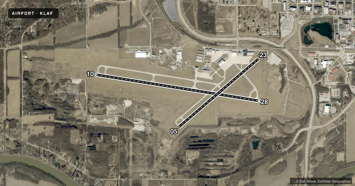
Runways & pattern
Full pagePattern entry · RWY 10
LEFT TRAFFIC| Runway | Heading (°M) | Length | Surface | Traffic |
|---|---|---|---|---|
| 10/28 | 98° / 278° | 6,600 ft | ASPH | Standard L |
| 05/23 | 49° / 229° | 4,225 ft | ASPH | Standard L |
Runway end performance
| End | TORA | TODA | ASDA | LDA | VGSI | Approach lights | Obstruction |
|---|---|---|---|---|---|---|---|
| 10 | 6,600' | 6,600' | 6,600' | 6,600' | PAPI 4-box left(3°) | MALSR | 97', trees, 3381' from thr, 968' R of cntrln, slope 32 |
| 28 | 6,600' | 6,600' | 6,600' | 6,600' | VASI 4-box right(3°) | — | 51', trees, 2057' from thr, 439' R of cntrln, slope 40 |
| 05 | 4,225' | 4,225' | 4,225' | 4,225' | PAPI 2-box left(3°) | — | — |
| 23 | 4,225' | 4,225' | 4,225' | 3,912' | PAPI 2-box left(3°) | — | 11', fence, 287' from thr, 132' R of cntrln, slope 7 |
Declared distances in feet. TORA = takeoff run available, TODA = takeoff distance, ASDA = accelerate-stop, LDA = landing distance.
Airport sketch
Runways drawn to scale from FAA survey coordinates, rendered over satellite imagery. Not for navigation.
Approaches & charts
ILS · 1
Services on the field
Fuel grades, oxygen, maintenance, ramp storage and lighting — as declared to the FAA by the airport operator.
Fuel & services
- Fuel
- 100LLA
- Oxygen (bulk)
- HIGH/LOW
- Airframe repair
- Major
- Power plant repair
- Major
- Other services
- AMB,AVNCS,CHTR,RNTL,SALES
Ramp & ground
- Transient storage
- Tie-down
- Hangar
- Landing fee
- No fee published
- Customs
- Not available
- Lighting schedule
- SEE RMK
- Beacon schedule
- SS-SR
- Beacon
- White / Green (civil land)(WG)
- Wind indicator
- Lighted
- Segmented circle
- No
Fuel & FBOs
Cheapest 100LL and Jet A on the field and nearby. Always confirm with the FBO before taxi.
Airport notes
Surface conditions, obstructions, local procedures, lighting outages and other notes published with each FAA cycle.
General notes
- TRNG OPS & BIRDS INVOF ARPT.
- SFC COND UNMNT 2200-0600 OR WKEND.
- FOR CD IF UNA TO CTC ON FSS FREQ, CTC CHICAGO ARTCC AT 630-906-8921.
Lighting notes
- WHEN ATCT CLSD ACTVT MALSR RWY 10; REIL RWY 5, 23 & 28; MIRL RWY 5/23; HIRL RWY 10/28 - CTAF.
Runway surface & condition
- 05/23PCR VALUE: 80/F/D/X/T
- 10/28PCR VALUE: 470/F/D/X/T
- 05/23RWY 05/23 NOT AVBL FOR PART 121/PART 380 OPS WITH SKED PAX CARRYING OPS MORE THAN 9 PAX SEATS AND NON-SKED PAX CARRYING OPS MORE THAN 30 PAX SEATS. WINGSPAN GTR THAN 79 FT NA.
Approach & departure obstructions
- 10PAPI UNUSBL BYD 9 DEGS RIGHT OF CNTRLN.
- 2320:1 AT DSPLCD THR.
Other notes
- UNSKED ACR OPS GTR THAN 30 PAX SEATS PPR - 765-496-6326 OR 765-496-4057. INDEX B ARFF CPBLY AVBL ON REQ.
VFR map & nearby airports
VFR sectional. Tap any ICAO chip to open that airport.
Key facts · KLAF
Answer card- ICAO
- KLAF
- Name
- PURDUE UNIVERSITY
- Location
- LAFAYETTE, INDIANA
- Elevation
- 605.8 ft MSL
- Traffic pattern altitude
- 1,605.8 ft MSL (1,000 AGL)
- Control tower
- Towered · 0700-2100
- Total runways
- 2
- Longest runway
- 10/28 · 6,600 ft
- Published ILS approaches
- 1
- Published frequencies
- 10
- Magnetic variation
- 1°
- Current flight rules
- LIFR
- Current wind
- 000° at 0 kt
- Favored runway now
- –
Purdue University Airport sits in Lafayette, Indiana. Field elevation is 605.8 ft MSL. The airport has 2 asphalt runways. The longest is 10/28 at 6,600 ft. Tower service is published from 0700 to 2100. One ILS is available for runway 10.
Pattern altitude is not published. Use 1,000 ft AGL for light piston traffic unless the current FAA Chart Supplement says otherwise. The field has a busy training environment. Birds are also reported in the area, so keep your scan active on arrival and departure. Runway 10 has a note on the PAPI. It is unusable beyond 9 degrees right of centerline. Runway 23 has a displaced threshold with an obstacle clearance slope issue, so brief that end before you use it.
Purdue Aviation is on the field. It carries 100LL, Jet A and Jet A Prist. If you need current ramp, fuel, or service details, call them directly at (765) 743-9692. When the tower is closed, lighting is activated on CTAF for the runways and approach lights. For current clearance delivery help, the published remarks point pilots to Chicago ARTCC if Flight Service cannot be reached. The airport also has published limits for some larger aircraft and certain scheduled passenger operations, so verify your aircraft and mission fit before you go.