METAR & TAF 1I9
1I9 does not publish a METAR.
Showing the nearest reporting station: KMCX (WHITE COUNTY) · 10.9 NM away. Conditions at 1I9 may differ.
METAR · KMCX
Observed 11:15Z
KMCX 271115Z AUTO 00000KT 1/4SM FG OVC002 22/22 A2990 RMK AO2 T02230215
- Wind
- 000° @ 0 kt
- Visibility
- 0.25 SM
- Temp / Dew
- 22°C / 22°C
- Altimeter
- 29.90 inHg
- Clouds
- OVC
- Density alt
- 1,697 ft
- Ceiling
- 200 ft AGL
- Rules
- LIFR
Airport info & contacts
Manager on record, flight service, ARTCC, attendance schedule and pattern altitude — published by the FAA and refreshed every 28 days.
Location
- From city
- 3 NM S
- VFR sectional
- CHICAGO
- ARTCC
- ZAU · CHICAGO
- NOTAM facility
- HUF (NOTAM-D)
Airport manager
- Name
- ED NAGLE
- Phone
- 765-564-4291
- Address
- 8296 W DIV LINE RD, DELPHI IN 46923
Flight service · Hours
- FSS HUF
- TERRE HAUTE1-800-WX-BRIEF
- Attendance
- IRREG
Frequencies
Tap any row to copy the frequency to your clipboard.
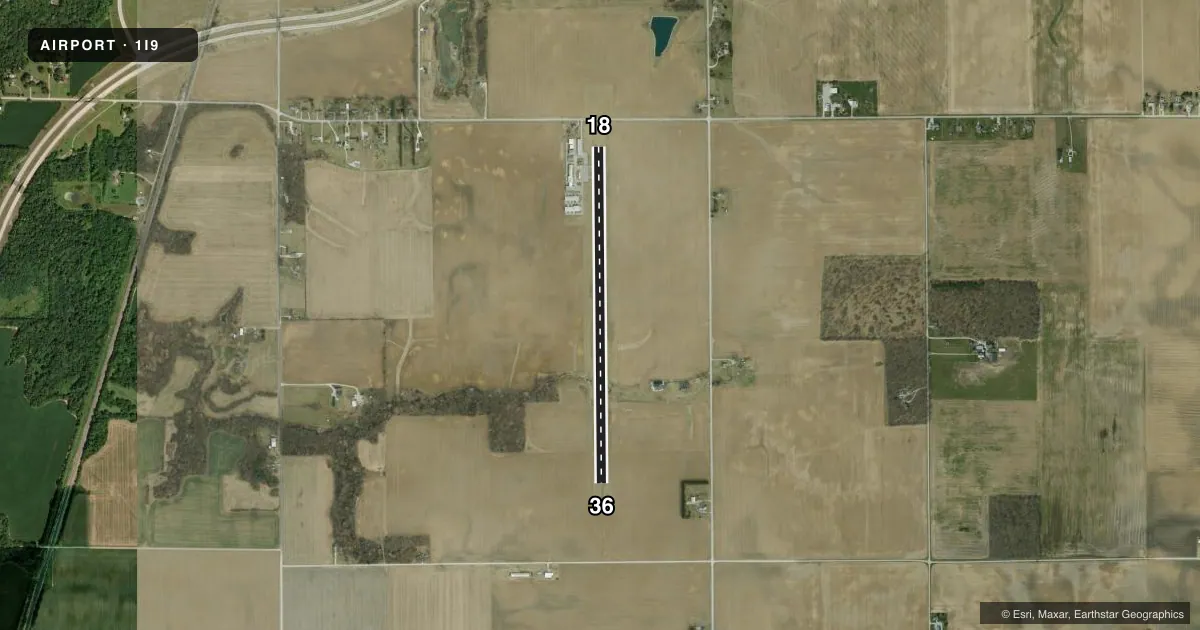
Runways & pattern
Full pagePattern entry · RWY 18
LEFT TRAFFICRunway end performance
| End | TORA | TODA | ASDA | LDA | VGSI | Approach lights | Obstruction |
|---|---|---|---|---|---|---|---|
| 18 | — | — | — | — | PAPI 2-box left(3°) | — | — |
| 36 | — | — | — | — | PAPI 2-box left(3°) | — | — |
Declared distances in feet. TORA = takeoff run available, TODA = takeoff distance, ASDA = accelerate-stop, LDA = landing distance.
Airport sketch
Runways drawn to scale from FAA survey coordinates, rendered over satellite imagery. Not for navigation.
Approaches & charts
Services on the field
Fuel grades, oxygen, maintenance, ramp storage and lighting — as declared to the FAA by the airport operator.
Fuel & services
- Fuel
- 100LL
- Airframe repair
- Minor
- Power plant repair
- Minor
Ramp & ground
- Transient storage
- Tie-down
- Landing fee
- No fee published
- Lighting schedule
- SEE RMK
- Beacon schedule
- SS-SR
- Beacon
- White / Green (civil land)(WG)
- Wind indicator
- Lighted
- Segmented circle
- No
Fuel & FBOs
Cheapest 100LL and Jet A on the field and nearby. Always confirm with the FBO before taxi.
Airport notes
Surface conditions, obstructions, local procedures, lighting outages and other notes published with each FAA cycle.
General notes
- 4 FT FENCE 100 FT W OF CNTRLN 200 FT S OF RWY 18 WI PRIM SFC.
- FOR CD CTC CHICAGO ARTCC AT 630-906-8921.
Lighting notes
- ACTVT REIL RWY 18 & 36; MIRL RWY 18/36 - CTAF. PAPI RWY 18 & 36 ON CONSLY.
Approach & departure obstructions
- 18ROAD 60 FT FM RWY END 1 FT ABOVE RWY.
- 18APCH SLOPE 20:1 AT DSPLCD THR DUE TO ROAD.
Other notes
- WHEN AVBL
- 2UNATNDD CHRISTMAS DAY.
- MANAGER260 316 4262.
VFR map & nearby airports
VFR sectional. Tap any ICAO chip to open that airport.
Key facts · 1I9
Answer card- ICAO
- 1I9
- Name
- DELPHI MUNI
- Location
- DELPHI, INDIANA
- Elevation
- 671.1 ft MSL
- Traffic pattern altitude
- 1,671.1 ft MSL (1,000 AGL)
- Control tower
- Non-towered (use CTAF)
- Total runways
- 1
- Longest runway
- 18/36 · 4,001 ft
- Published ILS approaches
- 0
- Published frequencies
- 3
- Magnetic variation
- 5°
- Current flight rules
- LIFR
- Current wind
- 000° at 0 kt
- Favored runway now
- –
Delphi Muni sits in Delphi, Indiana. Field elevation is 671.1 ft MSL. The airport has one runway, 18/36, which is 4,001 ft long and paved concrete. There is no control tower. CTAF is 122.9. Approach and departure support is handled through Grissom on 121.05 and 338.275.
No ILS approaches are published here. Pattern altitude is not published, so use the standard 1,000 ft AGL for light piston traffic unless the current Chart Supplement says otherwise. That puts the pattern at about 1,671 ft MSL based on the field elevation. The on-field FBO is Delphi Municipal Airport. It carries 100LL. Call (765) 564-4291 before you go if you need current services.
A few runway details matter here. Runway end identifier lights are on 18 and 36. Medium intensity runway lights are controlled by CTAF. PAPI is available on both ends and is on continuously. Runway 18 has a road close to the threshold, with a displaced-threshold approach slope note tied to that obstruction. There is also a fence west and south of runway 18 within the primary surface. For clearance delivery, contact Chicago ARTCC. The airport is unattended on Christmas Day. If you are planning a night arrival or a first stop here, review the current Chart Supplement and brief the runway lighting and threshold notes before descent.