METAR & TAF 5I6
5I6 does not publish a METAR.
Showing the nearest reporting station: KGUS (GRISSOM ARB) · 6.1 NM away. Conditions at 5I6 may differ.
METAR · KGUS
Observed 11:55Z
KGUS 271155Z 00000KT 7SM FEW120 BKN280 21/20 A2991 RMK AO2A SLP125 T02120200 RVRNO TSNO $
- Wind
- 000° @ 0 kt
- Visibility
- 7 SM
- Temp / Dew
- 21°C / 20°C
- Altimeter
- 29.91 inHg
- Clouds
- BKN
- Density alt
- 1,707 ft
- Ceiling
- 28,000 ft AGL
- Rules
- VFR
Airport info & contacts
Manager on record, flight service, ARTCC, attendance schedule and pattern altitude — published by the FAA and refreshed every 28 days.
Location
- From city
- 3 NM NW
- VFR sectional
- CHICAGO
- ARTCC
- ZAU · CHICAGO
- NOTAM facility
- HUF (NOTAM-D)
Airport manager
- Name
- JOHN ROBERSON
- Phone
- (765) 863-5759
- Address
- P O BOX 597, GALVESTON IN 46932
Flight service · Hours
- FSS HUF
- TERRE HAUTE1-800-WX-BRIEF
- Attendance
- Unattended
Frequencies
Tap any row to copy the frequency to your clipboard.
Runways & pattern
Full pagePattern entry · RWY 18
RIGHT TRAFFICRunway end performance
| End | TORA | TODA | ASDA | LDA | VGSI | Approach lights | Obstruction |
|---|---|---|---|---|---|---|---|
| 18 | — | — | — | — | — | — | 10', crops, 0' from thr, 0' R of cntrln, slope 0 |
| 36 | — | — | — | — | — | — | 10', crops, 0' from thr, 0' R of cntrln, slope 0 |
Declared distances in feet. TORA = takeoff run available, TODA = takeoff distance, ASDA = accelerate-stop, LDA = landing distance.
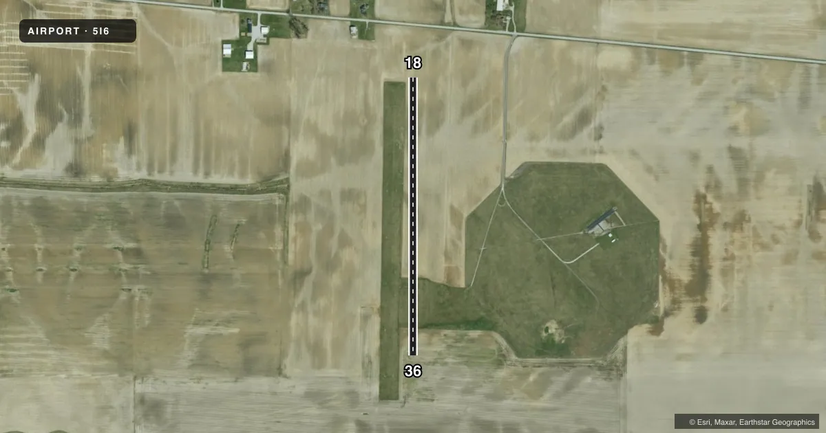
Airport sketch
Runways drawn to scale from FAA survey coordinates, rendered over satellite imagery. Not for navigation.
Approaches & charts
Services on the field
Fuel grades, oxygen, maintenance, ramp storage and lighting — as declared to the FAA by the airport operator.
Fuel & services
- Fuel
- Not available
- Oxygen (bottled)
- Not available
- Oxygen (bulk)
- Not available
- Airframe repair
- Not available
- Power plant repair
- Not available
- Other services
- AGRI
Ramp & ground
- Transient storage
- Not published
- Landing fee
- No fee published
- Customs
- Not available
- Wind indicator
- Yes
- Segmented circle
- Yes
Fuel & FBOs
Cheapest 100LL and Jet A on the field and nearby. Always confirm with the FBO before taxi.
Airport notes
Surface conditions, obstructions, local procedures, lighting outages and other notes published with each FAA cycle.
General notes
- INGRESS/EGRESS MUST BE COORDINATED WITH GRISSOM AFB APCH CTL ON FREQ 121.05 & ATCT ON FREQ 133.7.
- CROPS 100 FT E & W OF CL ENTIRE LENGTH RY 18/36.
- RY 18/36 EDGES & THLDS MKD WITH YELLOW & BLACK ALUMINUM STRIPS
- TAXI BTW ORANGE CONES TO ACCESS AIRCRAFT PARKING AREA
- FOR CD CTC CHICAGO ARTCC AT 630-906-8921.
Approach & departure obstructions
- 18APCH RATIO 27:1 TO PLINE 710 FT FM THLD.
Other notes
- EXISTED PRIOR TO 1959.
- BLACK & YELLOW GND LEVEL SEGMENTED CIRCLE.
VFR map & nearby airports
VFR sectional. Tap any ICAO chip to open that airport.
Key facts · 5I6
Answer card- ICAO
- 5I6
- Name
- GALVESTON
- Location
- GALVESTON, INDIANA
- Elevation
- 786 ft MSL
- Traffic pattern altitude
- 1,786 ft MSL (1,000 AGL)
- Control tower
- Non-towered (use CTAF)
- Total runways
- 1
- Longest runway
- 18/36 · 2,720 ft
- Published ILS approaches
- 0
- Published frequencies
- 1
- Magnetic variation
- 2°
- Current flight rules
- VFR
- Current wind
- 000° at 0 kt
- Favored runway now
- –
Galveston Airport (5I6) is in Galveston, Indiana. The field elevation is 786 ft MSL. It has one runway. Runway 18/36 is 2,720 ft long and turf. The airport is non-towered. CTAF is 122.9.
No ILS approaches are published here. The pattern altitude is not published in the facts. Use the standard 1,000 ft AGL for light piston operations unless the current Chart Supplement says otherwise. Published remarks show yellow and black aluminum strips marking the runway edges and thresholds. Taxi to the parking area is between orange cones. There is also a black and yellow segmented circle on the field.
This is a field where the published remarks matter. Crops sit 100 feet east and west of the runway centerline for the full length of 18/36. There is also a published obstruction note for the 18 approach. Ingress and egress must be coordinated with Grissom Air Force Base Approach Control on 121.05 and the tower on 133.7. For clearance delivery, contact Chicago ARTCC at 630-906-8921. No on-field FBOs are listed, so call the airport operator directly or check with the field on CTAF before you go.