METAR & TAF KOKK
Current METAR
Observed 12:16Z
KOKK 271216Z AUTO 11003KT 2 1/2SM BR CLR 20/20 A2994 RMK AO2 $
- Wind
- 110° @ 3 kt
- Visibility
- 0.5 SM
- Temp / Dew
- 20°C / 20°C
- Altimeter
- 29.94 inHg
- Clouds
- CLR
- Density alt
- 1,607 ft
- Ceiling
- Unlimited
- Rules
- LIFR
Airport info & contacts
Manager on record, flight service, ARTCC, attendance schedule and pattern altitude — published by the FAA and refreshed every 28 days.
Location
- From city
- 4 NM NE
- VFR sectional
- CHICAGO
- ARTCC
- ZAU · CHICAGO
- NOTAM facility
- OKK (NOTAM-D)
Airport manager
- Name
- SHAUN BAKER
- Phone
- 812-870-7734
- Address
- 3637 E COUNTY RD 400N, KOKOMO IN 46901
Flight service · Hours
- FSS HUF
- TERRE HAUTE1-800-WX-BRIEF
- Attendance
- 0800-1800
Frequencies
Tap any row to copy the frequency to your clipboard.
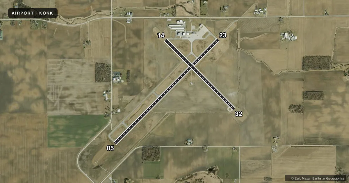
Runways & pattern
Full pagePattern entry · RWY 14
LEFT TRAFFIC| Runway | Heading (°M) | Length | Surface | Traffic |
|---|---|---|---|---|
| 05/23 | 40° / 220° | 6,001 ft | ASPH | Standard L |
| 14/32Favored | 130° / 310° | 4,001 ft | ASPH | Standard L |
Runway end performance
| End | TORA | TODA | ASDA | LDA | VGSI | Approach lights | Obstruction |
|---|---|---|---|---|---|---|---|
| 05 | — | — | — | — | PAPI 2-box left(3°) | — | — |
| 23 | — | — | — | — | — | MALSR | 53', tree, 1080' from thr, 625' R of cntrln, slope 16 |
| 14 | — | — | — | — | PAPI 2-box left(3.17°) | — | — |
| 32 | — | — | — | — | PAPI 2-box left(3.18°) | — | — |
Declared distances in feet. TORA = takeoff run available, TODA = takeoff distance, ASDA = accelerate-stop, LDA = landing distance.
Airport sketch
Runways drawn to scale from FAA survey coordinates, rendered over satellite imagery. Not for navigation.
Approaches & charts
ILS · 1
Services on the field
Fuel grades, oxygen, maintenance, ramp storage and lighting — as declared to the FAA by the airport operator.
Fuel & services
- Fuel
- 100LLA1+
- Oxygen (bottled)
- Not available
- Oxygen (bulk)
- Not available
- Airframe repair
- Major
- Power plant repair
- Major
- Other services
- AGRI,INSTR,SALES
Ramp & ground
- Transient storage
- Tie-down
- Landing fee
- No fee published
- Customs
- Not available
- Lighting schedule
- SEE RMK
- Beacon schedule
- SS-SR
- Beacon
- White / Green (civil land)(WG)
- Wind indicator
- Lighted
- Segmented circle
- No
Fuel & FBOs
Cheapest 100LL and Jet A on the field and nearby. Always confirm with the FBO before taxi.
Airport notes
Surface conditions, obstructions, local procedures, lighting outages and other notes published with each FAA cycle.
Lighting notes
- ACTVT MALSR RWY 23; REIL RWY 05, 14, & 32; PAPI RWY 05, 14, & 32; HIRL RWY 05/23; MIRL RWY 14/32 - CTAF.
Approach & departure obstructions
- 05CROPS 135 FT R & 320 FT L OF CL
- 14CROPS 170 FT R OF CL
- 23CROPS 140 FT R OF CL
- 32CROPS 155 FT L & 185 R OF CL
VFR map & nearby airports
VFR sectional. Tap any ICAO chip to open that airport.
Key facts · KOKK
Answer card- ICAO
- KOKK
- Name
- KOKOMO MUNI
- Location
- KOKOMO, INDIANA
- Elevation
- 832.2 ft MSL
- Traffic pattern altitude
- 1,832.2 ft MSL (1,000 AGL)
- Control tower
- Non-towered (use CTAF)
- Total runways
- 2
- Longest runway
- 05/23 · 6,001 ft
- Published ILS approaches
- 1
- Published frequencies
- 5
- Magnetic variation
- 5°
- Current flight rules
- LIFR
- Current wind
- 110° at 3 kt
- Favored runway now
- RWY 14
Kokomo Muni sits in Kokomo, Indiana. Field elevation is 832.2 ft MSL. The airport has two asphalt runways. The longest is 6,001 ft on 05/23. There is no control tower, so use CTAF 123.0 and UNICOM 123.0 for self-announce traffic. The field has one ILS approach to runway 23. Pattern altitude is not published, so plan on the standard 1,000 ft AGL for light piston ops unless the current Chart Supplement says otherwise.
The on-field FBO is Kokomo Municipal Airport. It carries 100LL and Jet A with Prist. Call (765) 456-1742 before arrival if you need current ramp or service details. Published remarks show runway lighting is well equipped. Runway 05/23 has high intensity lights. Runway 14/32 has medium intensity lights. Runway 23 also has MALSR lighting. REILs are installed on runways 05 and 14/32. PAPI is available on 05, 14 and 32.
This is an uncontrolled airport with a published ILS and a long primary runway. That makes it a practical stop for piston traffic and some turbine ops. Watch the crop obstructions near all runway ends. They sit close enough to matter on short final and during climbout. Check the current Chart Supplement for any changes before you go.