METAR & TAF KMZZ
Current METAR
Observed 13:35Z
KMZZ 271335Z AUTO 18003KT 1/2SM FG 22/21 A2994 RMK AO2 T02160206
- Wind
- 180° @ 3 kt
- Visibility
- 0.5 SM
- Temp / Dew
- 22°C / 21°C
- Altimeter
- 29.94 inHg
- Clouds
- Clear
- Density alt
- 1,880 ft
- Ceiling
- Unlimited
- Rules
- LIFR
Airport info & contacts
Manager on record, flight service, ARTCC, attendance schedule and pattern altitude — published by the FAA and refreshed every 28 days.
Location
- From city
- 3 NM SW
- VFR sectional
- CHICAGO
- ARTCC
- ZAU · CHICAGO
- NOTAM facility
- HUF (NOTAM-D)
Airport manager
- Name
- ANDY DARLINGTON
- Phone
- 765-674-7777
- Address
- 5904 S WESTERN AVE, MARION IN 46953
Flight service · Hours
- FSS HUF
- TERRE HAUTE1-800-WX-BRIEF
- Attendance
- MON-FRI · 0700-1800
- SAT · 0800-1700
- SUN · 0800-1700
Frequencies
Tap any row to copy the frequency to your clipboard.
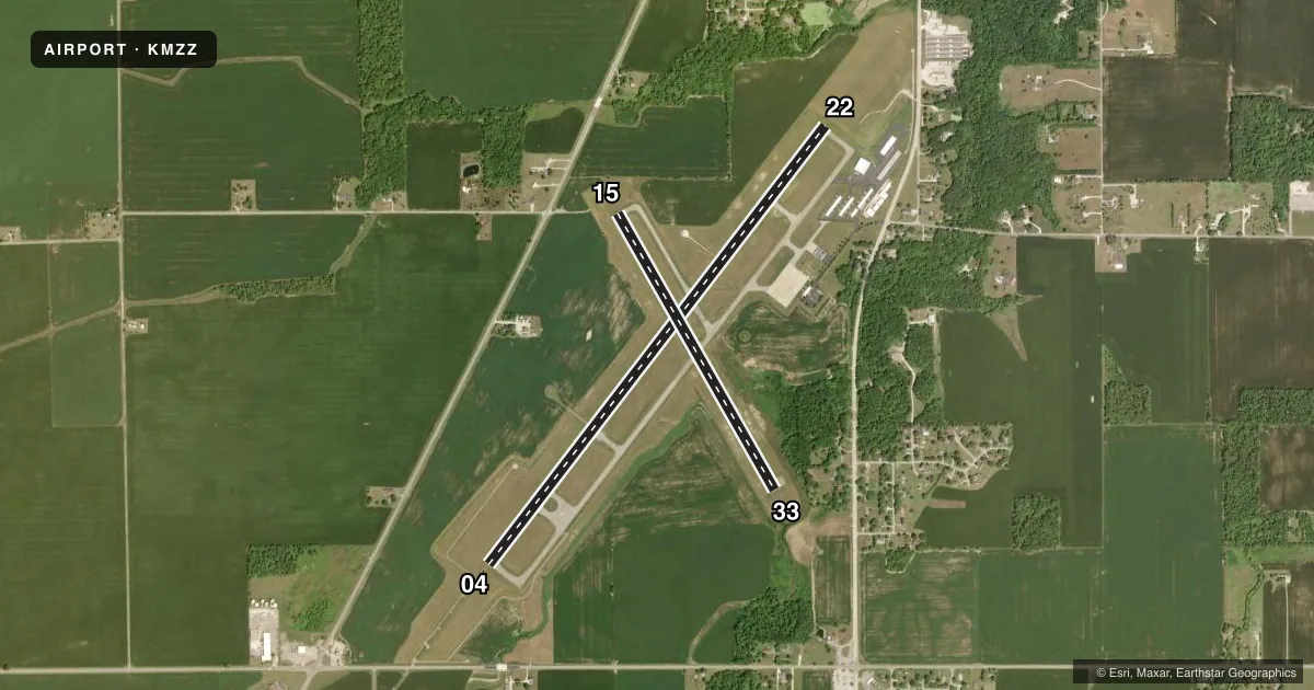
Runways & pattern
Full pagePattern entry · RWY 15
LEFT TRAFFIC| Runway | Heading (°M) | Length | Surface | Traffic |
|---|---|---|---|---|
| 04/22 | 34° / 214° | 6,011 ft | ASPH | Standard L |
| 15/33Favored | 147° / 327° | 3,456 ft | ASPH | Standard L |
Runway end performance
| End | TORA | TODA | ASDA | LDA | VGSI | Approach lights | Obstruction |
|---|---|---|---|---|---|---|---|
| 04 | — | — | — | — | — | MALSR | — |
| 22 | — | — | — | — | PAPI 4-box left(3°) | — | — |
| 15 | — | — | — | — | PAPI 2-box left(3.25°) | — | 15', tree, 400' from thr, 120' R of cntrln, slope 13 |
| 33 | — | — | — | — | PAPI 2-box left(4°) | — | 10', trees, 300' from thr, 190' R of cntrln, slope 10 |
Declared distances in feet. TORA = takeoff run available, TODA = takeoff distance, ASDA = accelerate-stop, LDA = landing distance.
Airport sketch
Runways drawn to scale from FAA survey coordinates, rendered over satellite imagery. Not for navigation.
Approaches & charts
ILS · 1
Services on the field
Fuel grades, oxygen, maintenance, ramp storage and lighting — as declared to the FAA by the airport operator.
Fuel & services
- Fuel
- 100LLA
- Oxygen (bottled)
- Low pressure
- Oxygen (bulk)
- Low pressure
- Airframe repair
- Major
- Power plant repair
- Major
- Other services
- INSTR,RNTL
Ramp & ground
- Transient storage
- Tie-down
- Hangar
- Landing fee
- No fee published
- Customs
- Not available
- Lighting schedule
- SEE RMK
- Beacon schedule
- SS-SR
- Beacon
- White / Green (civil land)(WG)
- Wind indicator
- Lighted
- Segmented circle
- Yes
Fuel & FBOs
Cheapest 100LL and Jet A on the field and nearby. Always confirm with the FBO before taxi.
Airport notes
Surface conditions, obstructions, local procedures, lighting outages and other notes published with each FAA cycle.
General notes
- FOR CD CTC CHICAGO ARTCC AT 630-906-8921.
Lighting notes
- ACTVT MALSR RWY 04; REIL RWY 15, 22 & 33; PAPI RWY 22- CTAF. PAPI RWY 15 & 33 ON DURG DAY; ACTVT AT NIGHT- CTAF. HIRL RWY 04/22; MIRL RWY 15/33 PRESET LOW INTST; INCR INTST - CTAF.
Fuel notes
- 100LLSELF SVC AVBL.
Approach & departure obstructions
- 22CROPS 285 R & 315 L OF CNTRLN.
- 33-12 FT DITCH 200 FT L OF CNTRLN; 8 - 10 FT GND 230 FT L OF CNTRLN PARL S HALF OF RWY.
- 33PAPI UNUSBL BYD 9 DEGS LEFT OF CNTRLN.
Other notes
- 1UNATNDD CHRISTMAS DAY.
VFR map & nearby airports
VFR sectional. Tap any ICAO chip to open that airport.
Key facts · KMZZ
Answer card- ICAO
- KMZZ
- Name
- MARION MUNI - MCKINNEY FLD
- Location
- MARION, INDIANA
- Elevation
- 858.7 ft MSL
- Traffic pattern altitude
- 1,858.7 ft MSL (1,000 AGL)
- Control tower
- Non-towered (use CTAF)
- Total runways
- 2
- Longest runway
- 04/22 · 6,011 ft
- Published ILS approaches
- 1
- Published frequencies
- 5
- Magnetic variation
- 3°
- Current flight rules
- LIFR
- Current wind
- 180° at 3 kt
- Favored runway now
- RWY 15
Marion Muni - McKinney Fld sits in Marion, Indiana at 858.7 ft MSL. It has two asphalt runways. The longest is 6,011 ft on 04/22. The field is unattended on Christmas Day. There is no control tower, so expect CTAF work on 122.7. Coordinate with other traffic early.
The airport has one ILS approach. It is for runway 04. Pattern altitude is not published, so use the standard 1,000 ft AGL for light piston operations unless the current Chart Supplement says otherwise. Runway lighting is useful here. MALSR is available for runway 04. REIL is available for 15, 22 and 33. PAPI is available on runway 22 on CTAF. PAPI on 15 and 33 is available in the day and at night on CTAF. Runway 04 and 22 have high-intensity lights. Runway 15 and 33 have medium-intensity lights that start low and can be increased on CTAF.
Air Marion is on the field. It carries 100LL and Jet A. Self-serve 100LL is also available. For clearance delivery, Chicago ARTCC can be reached at 630-906-8921. First-time pilots should pay attention to the published runway 22 crop obstructions near the centerline. Runway 33 also has terrain and ditch notes on the south half. The PAPI is unusable beyond 9 degrees left of centerline.