METAR & TAF KIWH
KIWH does not publish a METAR.
Showing the nearest reporting station: KHHG (HUNTINGTON MUNI) · 16.5 NM away. Conditions at KIWH may differ.
METAR · KHHG
Observed 12:15Z
KHHG 271215Z AUTO 00000KT 7SM CLR 21/21 A2995 RMK AO2 T02070207
- Wind
- 000° @ 0 kt
- Visibility
- 7 SM
- Temp / Dew
- 21°C / 21°C
- Altimeter
- 29.95 inHg
- Clouds
- CLR
- Density alt
- 1,669 ft
- Ceiling
- Unlimited
- Rules
- VFR
Airport info & contacts
Manager on record, flight service, ARTCC, attendance schedule and pattern altitude — published by the FAA and refreshed every 28 days.
Location
- From city
- 3 NM SE
- VFR sectional
- CHICAGO
- ARTCC
- ZAU · CHICAGO
- NOTAM facility
- HUF (NOTAM-D)
Airport manager
- Name
- JONATHAN DERBY
- Phone
- 260-563-4705
- Address
- 283 W. 400 S., WABASH IN 46992
Flight service · Hours
- FSS HUF
- TERRE HAUTE1-800-WX-BRIEF
- Attendance
- MAY-OCT · MON - SAT · 0800-1800
- NOV-APR · MON - SAT · 0800-1700
- MAY - OCT · SUN · 1230 - 1730
- NOV - APR · SUN · 1230 - 1700
Frequencies
Tap any row to copy the frequency to your clipboard.
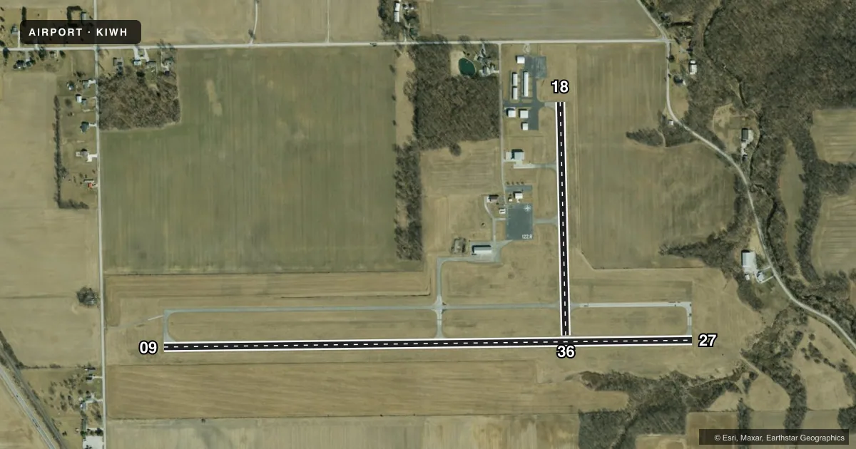
Runways & pattern
Full pagePattern entry · RWY 09
LEFT TRAFFIC| Runway | Heading (°M) | Length | Surface | Traffic |
|---|---|---|---|---|
| 09/27 | 86° / 266° | 4,401 ft | CONC | Standard L |
| 18/36 | 176° / 356° | 1,940 ft | ASPH | Standard L |
Runway end performance
| End | TORA | TODA | ASDA | LDA | VGSI | Approach lights | Obstruction |
|---|---|---|---|---|---|---|---|
| 09 | — | — | — | — | PAPI 2-box left(3°) | — | 15', road, 500' from thr, 0' R of cntrln, slope 20 |
| 27 | — | — | — | — | PAPI 2-box left(3°) | — | 53', trees, 1380' from thr, 0' R of cntrln, slope 22 |
| 18 | — | — | — | — | — | — | 84', trees, 1440' from thr, 0' R of cntrln, slope 14 |
| 36 | — | — | — | — | — | — | 60', trees, 650' from thr, 100' R of cntrln, slope 8 |
Declared distances in feet. TORA = takeoff run available, TODA = takeoff distance, ASDA = accelerate-stop, LDA = landing distance.
Airport sketch
Runways drawn to scale from FAA survey coordinates, rendered over satellite imagery. Not for navigation.
Approaches & charts
Services on the field
Fuel grades, oxygen, maintenance, ramp storage and lighting — as declared to the FAA by the airport operator.
Fuel & services
- Fuel
- 100LLA
- Other services
- AMB,CHTR,INSTR,RNTL
Ramp & ground
- Transient storage
- Tie-down
- Landing fee
- No fee published
- Customs
- Not available
- Lighting schedule
- SEE RMK
- Beacon schedule
- SS-SR
- Beacon
- White / Green (civil land)(WG)
- Wind indicator
- Lighted
- Segmented circle
- No
Fuel & FBOs
Cheapest 100LL and Jet A on the field and nearby. Always confirm with the FBO before taxi.
Airport notes
Surface conditions, obstructions, local procedures, lighting outages and other notes published with each FAA cycle.
General notes
- FOR CD CTC CHICAGO ARTCC AT 630-906-8921.
Lighting notes
- ACTVT REIL RWY 09 & 27 - CTAF. MIRL RWY 09/27 PRESET LOW INTST; INCR INTST - CTAF.
Fuel notes
- 100LLAVBL H24 WITH CREDIT CARD.
Approach & departure obstructions
- 09ULTRALIGHT USE R TFC PAT.
- 18APCH RATIO 20:1 TO DTHR.
- 09+54 FT UNLGTD PLINE 1275 FT FM RWY END; 19:1 OBSTN CLNC SLOPE.
VFR map & nearby airports
VFR sectional. Tap any ICAO chip to open that airport.
Key facts · KIWH
Answer card- ICAO
- KIWH
- Name
- WABASH MUNI
- Location
- WABASH, INDIANA
- Elevation
- 795.6 ft MSL
- Traffic pattern altitude
- 1,795.6 ft MSL (1,000 AGL)
- Control tower
- Non-towered (use CTAF)
- Total runways
- 2
- Longest runway
- 09/27 · 4,401 ft
- Published ILS approaches
- 0
- Published frequencies
- 4
- Magnetic variation
- 3°
- Current flight rules
- VFR
- Current wind
- 000° at 0 kt
- Favored runway now
- –
Wabash Muni sits in Wabash, Indiana. Field elevation is 795.6 ft MSL. The airport has two runways. The longest is 09/27 at 4,401 ft. Runway 18/36 is 1,940 ft. There is no control tower. No ILS approaches are published here.
Pattern altitude is not published. For light piston aircraft, plan on the standard 1,000 ft AGL unless the current Chart Supplement or local procedures say otherwise. The field uses CTAF 122.8. UNICOM is also 122.8. Northern Indiana Aviation is on the field. It carries 100LL and Jet A with Prist. 100LL is available 24 hours a day with a credit card.
A few operational items matter here. Runway 09 has a 54-foot unlighted power line 1,275 ft from the departure end. Runway 18 has a published obstruction clearance slope to the decision threshold. Runway end identifier lights on 09 and 27 are activated by radio. The medium intensity runway lights on 09 and 27 start at low intensity. Use the CTAF to raise them. Ultralights use right traffic for runway 09. For clearance delivery, contact Chicago ARTCC. If you are planning a night or low-vis arrival, verify the current Chart Supplement and brief the lighting setup before you go.