METAR & TAF I76
I76 does not publish a METAR.
Showing the nearest reporting station: KGUS (GRISSOM ARB) · 8.3 NM away. Conditions at I76 may differ.
METAR · KGUS
Observed 09:55Z
KGUS 270955Z AUTO 00000KT 8SM CLR 20/19 A2987 RMK AO2 SLP111 T02020194 TSNO $
- Wind
- 000° @ 0 kt
- Visibility
- 8 SM
- Temp / Dew
- 20°C / 19°C
- Altimeter
- 29.87 inHg
- Clouds
- CLR
- Density alt
- 1,628 ft
- Ceiling
- Unlimited
- Rules
- VFR
Airport info & contacts
Manager on record, flight service, ARTCC, attendance schedule and pattern altitude — published by the FAA and refreshed every 28 days.
Location
- From city
- 4 NM NW
- VFR sectional
- CHICAGO
- ARTCC
- ZAU · CHICAGO
- NOTAM facility
- HUF (NOTAM-D)
Airport manager
- Name
- KELLY WOLF
- Phone
- 765-472-1990
- Address
- 1635 N. 400 W., PERU IN 46970
Flight service · Hours
- FSS HUF
- TERRE HAUTE1-800-WX-BRIEF
- Attendance
- MON-SAT · 0900-1700
- SUN · 1000-1600
Frequencies
Tap any row to copy the frequency to your clipboard.
Runways & pattern
Full pagePattern entry · RWY 01
LEFT TRAFFICRunway end performance
| End | TORA | TODA | ASDA | LDA | VGSI | Approach lights | Obstruction |
|---|---|---|---|---|---|---|---|
| 01 | — | — | — | — | PAPI 2-box left(3°) | — | 15', road, 451' from thr, 0' R of cntrln, slope 16 |
| 19 | — | — | — | — | PAPI 2-box left(3°) | — | 12', road, 450' from thr, 0' R of cntrln, slope 20 |
Declared distances in feet. TORA = takeoff run available, TODA = takeoff distance, ASDA = accelerate-stop, LDA = landing distance.
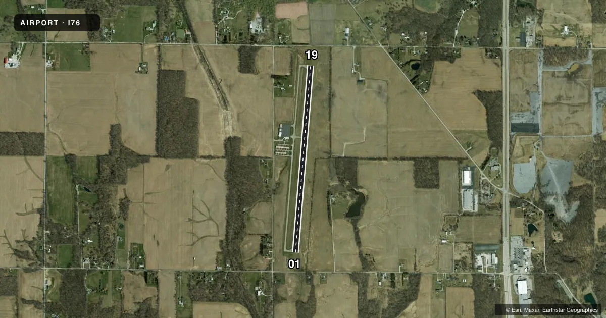
Airport sketch
Runways drawn to scale from FAA survey coordinates, rendered over satellite imagery. Not for navigation.
Approaches & charts
Services on the field
Fuel grades, oxygen, maintenance, ramp storage and lighting — as declared to the FAA by the airport operator.
Fuel & services
- Fuel
- 100LLA
- Oxygen (bottled)
- Not available
- Oxygen (bulk)
- Not available
- Airframe repair
- Not available
- Power plant repair
- Not available
Ramp & ground
- Transient storage
- Tie-down
- Hangar
- Landing fee
- No fee published
- Customs
- Not available
- Lighting schedule
- SEE RMK
- Beacon schedule
- SS-SR
- Beacon
- White / Green (civil land)(WG)
- Wind indicator
- Lighted
- Segmented circle
- No
Fuel & FBOs
Cheapest 100LL and Jet A on the field and nearby. Always confirm with the FBO before taxi.
Airport notes
Surface conditions, obstructions, local procedures, lighting outages and other notes published with each FAA cycle.
General notes
- EMERGENCY PHONE LOCATED INSIDE OF FUEL PUMP STATION
- FOR CD CTC CHICAGO ARTCC AT 630-906-8921.
Lighting notes
- ACTVT REIL RWY 01 & 19; MIRL RWY 01/19 - CTAF. PAPI RWY 01 & 19 OPR CONSLY.
Other notes
- ACTVT ADVISORY WX - UNICOM 4 CLICKS.
- 1CLSD MAJOR HOLIDAYS.
- MANAGEREMERG CTC 260-416-2381.
VFR map & nearby airports
VFR sectional. Tap any ICAO chip to open that airport.
Key facts · I76
Answer card- ICAO
- I76
- Name
- PERU MUNI
- Location
- PERU, INDIANA
- Elevation
- 778.8 ft MSL
- Traffic pattern altitude
- 1,778.8 ft MSL (1,000 AGL)
- Control tower
- Non-towered (use CTAF)
- Total runways
- 1
- Longest runway
- 01/19 · 4,400 ft
- Published ILS approaches
- 0
- Published frequencies
- 4
- Magnetic variation
- 4°
- Current flight rules
- VFR
- Current wind
- 000° at 0 kt
- Favored runway now
- –
Peru Muni Airport sits in Peru, Indiana. The field elevation is 778.8 ft MSL. It has one runway, 01/19, which is 4,400 ft long and asphalt. The airport is non-towered. Pattern altitude is not published, so use the standard 1,000 ft AGL for light piston traffic unless the current Chart Supplement says otherwise. No ILS approaches are published here.
The on-field FBO is Peru Municipal Airport. It carries AVGAS 100LL and Jet A. Call (765) 472-1990 before you go if you need current service details. The published remarks also matter. Runway end identifier lights are available for both runway ends. Medium intensity runway lights are activated on CTAF 122.8. The precision approach path indicators for runway 01 and 19 operate continuously. The airport is closed on major holidays.
For first-time arrivals, plan for a small non-towered field with a single runway and standard self-announced traffic flow on 122.8. Advisory weather can be activated on UNICOM with four microphone clicks. If you need clearance delivery, Chicago ARTCC is listed in the remarks. Check the current Chart Supplement before departure for any changes to procedures or local restrictions.