METAR & TAF KRCR
Current METAR
Observed 18:55Z
KRCR 261855Z AUTO 10SM SCT031 BKN040 28/22 A2993 RMK AO2
- Wind
- Calm
- Visibility
- 10 SM
- Temp / Dew
- 28°C / 22°C
- Altimeter
- 29.93 inHg
- Clouds
- BKN
- Density alt
- 2,527 ft
- Ceiling
- 4,000 ft AGL
- Rules
- VFR
Airport info & contacts
Manager on record, flight service, ARTCC, attendance schedule and pattern altitude — published by the FAA and refreshed every 28 days.
Location
- From city
- 2 NM E
- VFR sectional
- CHICAGO
- ARTCC
- ZAU · CHICAGO
- NOTAM facility
- HUF (NOTAM-D)
Airport manager
- Name
- MATT WOODS
- Phone
- 574-223-5384
- Address
- 545 STATE RD 25N, ROCHESTER IN 46975
Flight service · Hours
- FSS HUF
- TERRE HAUTE1-800-WX-BRIEF
- Attendance
- 0800-1700
Frequencies
Tap any row to copy the frequency to your clipboard.
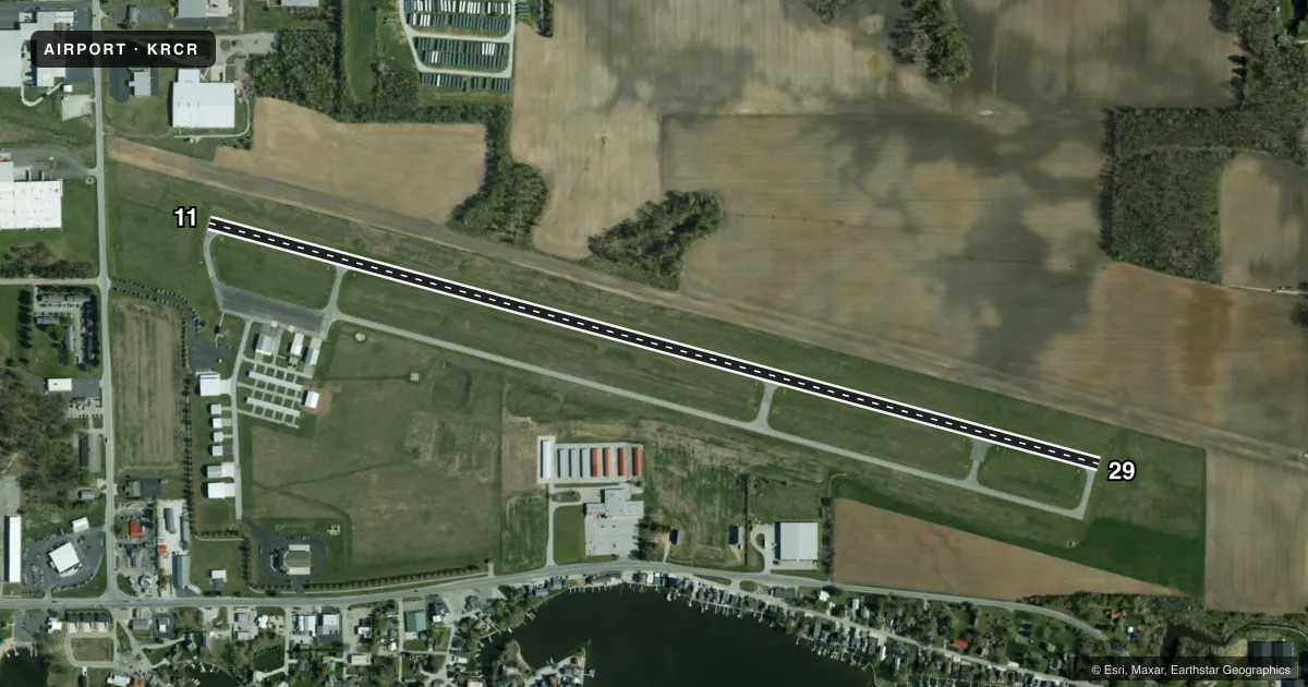
Runways & pattern
Full pagePattern entry · RWY 11
LEFT TRAFFICRunway end performance
| End | TORA | TODA | ASDA | LDA | VGSI | Approach lights | Obstruction |
|---|---|---|---|---|---|---|---|
| 11 | — | — | — | — | PAPI 2-box left(3.5°) | — | 15', road, 580' from thr, 0' R of cntrln, slope 25 |
| 29 | — | — | — | — | PAPI 2-box left(3.38°) | — | 85', trees, 3100' from thr, 0' R of cntrln, slope 35 |
Declared distances in feet. TORA = takeoff run available, TODA = takeoff distance, ASDA = accelerate-stop, LDA = landing distance.
Airport sketch
Runways drawn to scale from FAA survey coordinates, rendered over satellite imagery. Not for navigation.
Approaches & charts
Services on the field
Fuel grades, oxygen, maintenance, ramp storage and lighting — as declared to the FAA by the airport operator.
Fuel & services
- Fuel
- 100LLA
- Airframe repair
- Major
- Power plant repair
- Major
- Other services
- INSTR
Ramp & ground
- Transient storage
- Tie-down
- Hangar
- Landing fee
- No fee published
- Customs
- Not available
- Lighting schedule
- SEE RMK
- Beacon schedule
- SEE RMK
- Beacon
- White / Green (civil land)(WG)
- Wind indicator
- Lighted
- Segmented circle
- No
Fuel & FBOs
Cheapest 100LL and Jet A on the field and nearby. Always confirm with the FBO before taxi.
Airport notes
Surface conditions, obstructions, local procedures, lighting outages and other notes published with each FAA cycle.
General notes
- FOR CD CTC SOUTH BEND APCH AT 574-251-2609. WHEN SOUTH BEND APCH CLSD, FOR CD CTC CHICAGO ARTCC AT 630-906-8921.
Lighting notes
- ACTVT BCN - CTAF
- ACTVT REIL RWY 11 & 29; PAPI RWY 11 & 29; MIRL RWY 11/29 - CTAF.
Fuel notes
- 100LL100LL SELF SVC AVBL H24.
Other notes
- THIS AIRPORT HAS BEEN SURVEYED BY THE NATIONAL GEODETIC SURVEY.
VFR map & nearby airports
VFR sectional. Tap any ICAO chip to open that airport.
Key facts · KRCR
Answer card- ICAO
- KRCR
- Name
- FULTON COUNTY
- Location
- ROCHESTER, INDIANA
- Elevation
- 789.5 ft MSL
- Traffic pattern altitude
- 1,789.5 ft MSL (1,000 AGL)
- Control tower
- Non-towered (use CTAF)
- Total runways
- 1
- Longest runway
- 11/29 · 5,001 ft
- Published ILS approaches
- 0
- Published frequencies
- 4
- Magnetic variation
- 3°
- Current flight rules
- VFR
- Current wind
- Calm / unavailable
- Favored runway now
- –
Fulton County Airport (KRCR) sits in Rochester, Indiana. The field elevation is 789.5 ft MSL. It has one runway. Runway 11/29 is 5,001 ft long with an asphalt surface. There is no control tower. The runway end identifier lights, the PAPI for Runways 11 and 29, the medium intensity runway lights for 11/29 and the airport beacon are activated by CTAF. No ILS approaches are published here. Pattern altitude is not published, so use the standard 1,000 ft AGL for light piston traffic unless the current Chart Supplement says otherwise. That puts the traffic pattern at about 1,790 ft MSL based on the field elevation.
Fulton County Aviation is on the field. It carries 100LL and Jet A. 100LL self-service fuel is available 24 hours a day. For clearance delivery, South Bend Approach handles it when open. When South Bend Approach is closed, Chicago ARTCC handles clearance delivery. This is a small non-towered field, so keep your radio work tight on CTAF 122.7. The published remarks also note that the airport has been surveyed by the National Geodetic Survey. Check the current Chart Supplement for any noise or local operating notes before you go.