METAR & TAF C65
Current METAR
Observed 10:55Z
KC65 271055Z AUTO 00000KT 1/4SM FG OVC002 22/22 A2991 RMK A01
- Wind
- 000° @ 0 kt
- Visibility
- 0.25 SM
- Temp / Dew
- 22°C / 22°C
- Altimeter
- 29.91 inHg
- Clouds
- OVC
- Density alt
- 1,844 ft
- Ceiling
- 200 ft AGL
- Rules
- LIFR
Airport info & contacts
Manager on record, flight service, ARTCC, attendance schedule and pattern altitude — published by the FAA and refreshed every 28 days.
Location
- From city
- 2 NM N
- VFR sectional
- CHICAGO
- ARTCC
- ZAU · CHICAGO
- NOTAM facility
- HUF (NOTAM-D)
Airport manager
- Name
- BILL SHELEY
- Phone
- (574) 320-5059
- Address
- 301 AIRPORT DRIVE, PLYMOUTH IN 46563
Flight service · Hours
- FSS HUF
- TERRE HAUTE1-800-WX-BRIEF
- Attendance
- MON-FRI · 0800-1700
- SAT-SUN · BY APPT
Frequencies
Tap any row to copy the frequency to your clipboard.
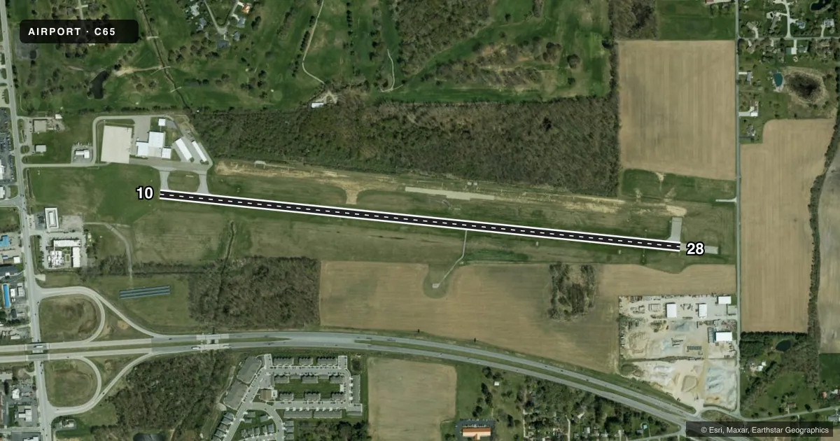
Runways & pattern
Full pagePattern entry · RWY 10
LEFT TRAFFICRunway end performance
| End | TORA | TODA | ASDA | LDA | VGSI | Approach lights | Obstruction |
|---|---|---|---|---|---|---|---|
| 10 | — | — | — | — | PAPI 2-box left(3°) | — | 85', tree, 2000' from thr, 183' R of cntrln, slope 21 |
| 28 | — | — | — | — | VASI 4-box left(3.3°) | — | 15', road, 490' from thr, 300' R of cntrln, slope 19 |
Declared distances in feet. TORA = takeoff run available, TODA = takeoff distance, ASDA = accelerate-stop, LDA = landing distance.
Airport sketch
Runways drawn to scale from FAA survey coordinates, rendered over satellite imagery. Not for navigation.
Approaches & charts
Services on the field
Fuel grades, oxygen, maintenance, ramp storage and lighting — as declared to the FAA by the airport operator.
Fuel & services
- Fuel
- 100LLA
- Airframe repair
- Major
- Power plant repair
- Major
- Other services
- AVNCS,INSTR,RNTL
Ramp & ground
- Transient storage
- Tie-down
- Hangar
- Landing fee
- No fee published
- Customs
- Not available
- Lighting schedule
- SEE RMK
- Beacon schedule
- SS-SR
- Beacon
- White / Green (civil land)(WG)
- Wind indicator
- Lighted
- Segmented circle
- Yes
Fuel & FBOs
Cheapest 100LL and Jet A on the field and nearby. Always confirm with the FBO before taxi.
Airport notes
Surface conditions, obstructions, local procedures, lighting outages and other notes published with each FAA cycle.
General notes
- FLT TRNG & BIRDS ON & INVOF ARPT.
- WINTER SNOW REMOVAL OPS; OPR MONITOR CTAF.
- FOR CD CTC SOUTH BEND APCH AT 574-251-2609. WHEN SOUTH BEND APCH CLSD, FOR CD CTC CHICAGO ARTCC AT 630-906-8921.
Lighting notes
- ACTVT REIL RWY 10 & 28; PAPI RWY 10; VASI RWY 28; MIRL RWY 10/28 - CTAF.
Fuel notes
- 100LLSELF SERVE AVBL H24.
Approach & departure obstructions
- 28APCH RATIO 34:1 AT DSPLCD THR.
Other notes
- OWNERPHIL BOCKMAN
VFR map & nearby airports
VFR sectional. Tap any ICAO chip to open that airport.
Key facts · C65
Answer card- ICAO
- C65
- Name
- PLYMOUTH MUNI
- Location
- PLYMOUTH, INDIANA
- Elevation
- 799.9 ft MSL
- Traffic pattern altitude
- 1,799.9 ft MSL (1,000 AGL)
- Control tower
- Non-towered (use CTAF)
- Total runways
- 1
- Longest runway
- 10/28 · 4,400 ft
- Published ILS approaches
- 0
- Published frequencies
- 4
- Magnetic variation
- 5°
- Current flight rules
- LIFR
- Current wind
- 000° at 0 kt
- Favored runway now
- –
PLYMOUTH MUNI is in Plymouth, Indiana. The field elevation is 799.9 ft MSL. It has one runway, 10/28 and the longest runway is 4,400 ft. There is no control tower. Pattern altitude is not published, so use the standard 1,000 ft AGL for light piston traffic unless the current Chart Supplement says otherwise.
No ILS approaches are published here. The airport uses CTAF 122.975, which is also listed as UNICOM. South Bend Approach handles IFR services on 132.05 and 257.8. For clearance delivery, the published remarks direct pilots to South Bend Approach at 574-251-2609. When South Bend Approach is closed, Chicago ARTCC handles clearance delivery at 630-906-8921.
The on-field FBO is Plymouth Municipal Airport. It carries 100LL and Jet A. Self-serve 100LL is available 24 hours a day. Published remarks also note winter snow removal, runway end identifier lights on 10 and 28, PAPI on runway 10 and VASI on runway 28. The airport also notes flight training and birds in the area. Runway 28 has a displaced threshold with a 34 to 1 approach slope ratio. Plan your landing profile carefully on that end.