METAR & TAF 3C1
3C1 does not publish a METAR.
Showing the nearest reporting station: KEKM (ELKHART MUNI) · 4.0 NM away. Conditions at 3C1 may differ.
METAR · KEKM
Observed 21:35Z
KEKM 262135Z AUTO 26007KT 8SM FEW034 SCT065 30/22 A2988 RMK AO2 T02970220 $
- Wind
- 260° @ 7 kt
- Visibility
- 8 SM
- Temp / Dew
- 30°C / 22°C
- Altimeter
- 29.88 inHg
- Clouds
- SCT
- Density alt
- 2,786 ft
- Ceiling
- Unlimited
- Rules
- VFR
Airport info & contacts
Manager on record, flight service, ARTCC, attendance schedule and pattern altitude — published by the FAA and refreshed every 28 days.
Location
- From city
- 3 NM SW
- VFR sectional
- CHICAGO
- ARTCC
- ZAU · CHICAGO
- NOTAM facility
- HUF (NOTAM-D)
Airport manager
- Name
- CHRIS RINGOS
- Phone
- (574) 675-7575
- Address
- 29580 COUNTY ROAD 20, ELKHART IN 46517
Flight service · Hours
- FSS HUF
- TERRE HAUTE1-800-WX-BRIEF
- Attendance
- IRREG
Frequencies
Tap any row to copy the frequency to your clipboard.
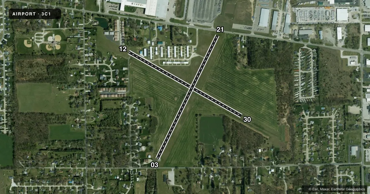
Runways & pattern
Full pagePattern entry · RWY 30
LEFT TRAFFIC| Runway | Heading (°M) | Length | Surface | Traffic |
|---|---|---|---|---|
| 12/30Favored | 117° / 297° | 3,140 ft | TURF | Standard L |
| 03/21 | 23° / 203° | 2,243 ft | ASPH | Standard L |
Runway end performance
| End | TORA | TODA | ASDA | LDA | VGSI | Approach lights | Obstruction |
|---|---|---|---|---|---|---|---|
| 12 | — | — | — | — | — | — | 75', trees, 255' from thr, 130' R of cntrln, slope 3 |
| 30 | — | — | — | — | — | — | 45', trees, 180' from thr, 120' R of cntrln, slope 4 |
| 03 | — | — | — | — | — | — | 15', road, 240' from thr, 125' R of cntrln, slope 2 |
| 21 | — | — | — | — | — | — | 15', road, 240' from thr, 130' R of cntrln, slope 2 |
Declared distances in feet. TORA = takeoff run available, TODA = takeoff distance, ASDA = accelerate-stop, LDA = landing distance.
Airport sketch
Runways drawn to scale from FAA survey coordinates, rendered over satellite imagery. Not for navigation.
Approaches & charts
Services on the field
Fuel grades, oxygen, maintenance, ramp storage and lighting — as declared to the FAA by the airport operator.
Fuel & services
- Fuel
- Not available
- Other services
- INSTR
Ramp & ground
- Transient storage
- Tie-down
- Landing fee
- No fee published
- Customs
- Not available
- Lighting schedule
- SS-SR
- Beacon schedule
- SEE RMK
- Beacon
- White / Green (civil land)(WG)
- Wind indicator
- Lighted
- Segmented circle
- No
Fuel & FBOs
Cheapest 100LL and Jet A on the field and nearby. Always confirm with the FBO before taxi.
Airport notes
Surface conditions, obstructions, local procedures, lighting outages and other notes published with each FAA cycle.
General notes
- FOR CD CTC SOUTH BEND APCH 574-251-2609. WHEN SOUTH BEND APCH CLSD, FOR CD CTC CHICAGO ARTCC AT 630-906-8921.
Lighting notes
- OTS INDEFLY.
- DUSK-DAWN.
Approach & departure obstructions
- 12GND MKRS.
- 30GND MKRS.
- 03APCH SLOPE 28:1 FM DTHR.
- 12APCH SLOPE 12:1 FM DTHR.
- 21APCH SLOPE 29:1 FM DTHR.
Other notes
- EXISTED PRIOR TO 1959.
VFR map & nearby airports
VFR sectional. Tap any ICAO chip to open that airport.
Key facts · 3C1
Answer card- ICAO
- 3C1
- Name
- MISHAWAKA PILOTS CLUB
- Location
- ELKHART, INDIANA
- Elevation
- 755 ft MSL
- Traffic pattern altitude
- 1,755 ft MSL (1,000 AGL)
- Control tower
- Non-towered (use CTAF)
- Total runways
- 2
- Longest runway
- 12/30 · 3,140 ft
- Published ILS approaches
- 0
- Published frequencies
- 1
- Magnetic variation
- 3°
- Current flight rules
- VFR
- Current wind
- 260° at 7 kt
- Favored runway now
- RWY 30
Mishawaka Pilots Club is in Elkhart, Indiana. The field elevation is 755 ft MSL. It has two runways. The longest is 3,140 ft on runway 12/30, which is turf. Runway 03/21 is 2,243 ft asphalt. There is no control tower. CTAF is 122.9.
No ILS approaches are published here. Pattern altitude is not published, so use the standard 1,000 ft AGL for light piston operations unless the current FAA Chart Supplement says otherwise. That puts the pattern at 1,755 ft MSL based on the field elevation. Verify the current published pattern before you fly. The airport is a non-towered field, so expect self-announce traffic and keep a close scan in the pattern.
Published remarks matter here. South Bend Approach handles clearance delivery when needed. If South Bend Approach is closed, Chicago ARTCC is the backup contact for clearance delivery. The beacon is out of service indefinitely. Runway 30 has ground markers. Runway 12 has ground markers. The approach slopes are steeply limited on runway 03, runway 21 and runway 12, so pay attention to displaced threshold and obstacle clearance details before arrival. There are no on-field FBOs listed. Contact the airport operator directly or call the field on CTAF for current fuel and service availability.