METAR & TAF KEKM
Current METAR
Observed 12:15Z
KEKM 271215Z AUTO 24009KT 4SM -RA BR BKN008 BKN012 23/23 A2989 RMK AO2 P0000 T02300230 $
- Wind
- 240° @ 9 kt
- Visibility
- 4 SM
- Temp / Dew
- 23°C / 23°C
- Altimeter
- 29.89 inHg
- Clouds
- BKN
- Density alt
- 1,961 ft
- Ceiling
- 800 ft AGL
- Rules
- IFR
Airport info & contacts
Manager on record, flight service, ARTCC, attendance schedule and pattern altitude — published by the FAA and refreshed every 28 days.
Location
- From city
- 3 NM NW
- VFR sectional
- CHICAGO
- ARTCC
- ZAU · CHICAGO
- NOTAM facility
- EKM (NOTAM-D)
Airport manager
- Name
- ANDY JONES
- Phone
- 574-264-5217
- Address
- 1211 CO RD 6 W, ELKHART IN 46514
Flight service · Hours
- FSS HUF
- TERRE HAUTE1-800-WX-BRIEF
- Attendance
- 0600-2200
Frequencies
Tap any row to copy the frequency to your clipboard.
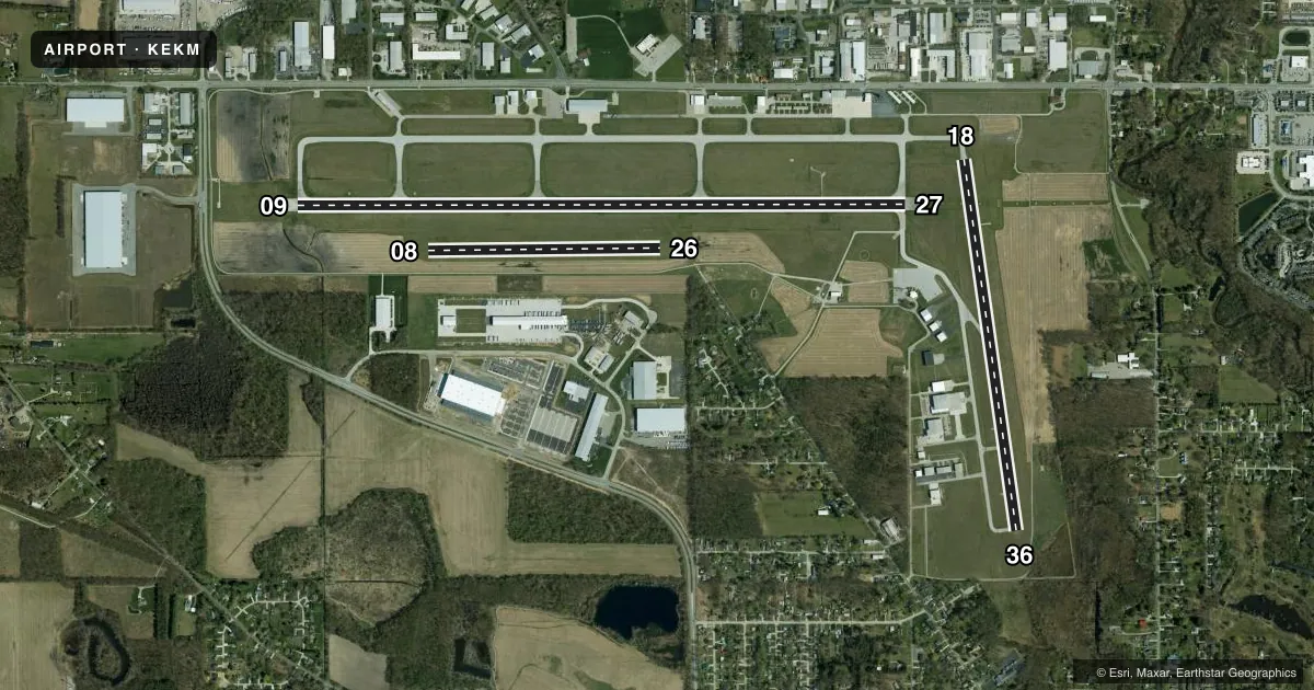
Runways & pattern
Full pagePattern entry · RWY 26
LEFT TRAFFIC| Runway | Heading (°M) | Length | Surface | Traffic |
|---|---|---|---|---|
| 09/27 | 86° / 266° | 6,500 ft | CONC | Standard L |
| 18/36 | 168° / 348° | 3,999 ft | ASPH | Standard L |
| 08/26Favored | 85° / 265° | 2,480 ft | TURF | Standard L |
Runway end performance
| End | TORA | TODA | ASDA | LDA | VGSI | Approach lights | Obstruction |
|---|---|---|---|---|---|---|---|
| 09 | 6,500' | 6,500' | 6,500' | 6,500' | VASI 4-box left(3°) | — | 40', trees, 1050' from thr, 0' R of cntrln, slope 21 |
| 27 | 6,500' | 6,500' | 6,500' | 6,500' | PAPI 4-box left(3°) | MALSR | 69', trees, 2645' from thr, 0' R of cntrln, slope 35 |
| 18 | 4,001' | 4,001' | 4,001' | 4,001' | PAPI 4-box left(3°) | — | 40', trees, 1200' from thr, 0' R of cntrln, slope 25 |
| 36 | 4,001' | 4,001' | 4,001' | 4,001' | VASI 4-box left(4°) | — | 62', trees, 1200' from thr, 250' R of cntrln, slope 16 |
| 08 | 2,480' | 2,480' | 2,480' | 2,480' | — | — | — |
| 26 | 2,480' | 2,480' | 2,480' | 2,480' | — | — | — |
Declared distances in feet. TORA = takeoff run available, TODA = takeoff distance, ASDA = accelerate-stop, LDA = landing distance.
Airport sketch
Runways drawn to scale from FAA survey coordinates, rendered over satellite imagery. Not for navigation.
Approaches & charts
ILS · 1
Services on the field
Fuel grades, oxygen, maintenance, ramp storage and lighting — as declared to the FAA by the airport operator.
Fuel & services
- Fuel
- 100LLA
- Oxygen (bottled)
- Low pressure
- Oxygen (bulk)
- Not available
- Airframe repair
- Major
- Power plant repair
- Minor
- Other services
- CHTR,RNTL,SALES
Ramp & ground
- Transient storage
- Tie-down
- Hangar
- Landing fee
- No fee published
- Customs
- Not available
- Lighting schedule
- SEE RMK
- Beacon schedule
- SS-SR
- Beacon
- White / Green (civil land)(WG)
- Wind indicator
- Lighted
- Segmented circle
- Yes
Fuel & FBOs
Cheapest 100LL and Jet A on the field and nearby. Always confirm with the FBO before taxi.
Airport notes
Surface conditions, obstructions, local procedures, lighting outages and other notes published with each FAA cycle.
General notes
- TWY MKD WITH REFLECTORS; TWY A UNAVBL TO ACFT WITH MORE THAN 30 PAX SEATS.
- (E94) SWARS.
- FOR CD WHEN ATCT CLSD, CTC SOUTH BEND ATCT ON FREQ. WHEN SOUTH BEND ATCT CLSD, CTC CHICAGO ARTCC AT 630-906-8921.
Lighting notes
- ACTVT MALSR RWY 27; REIL RWY 09, 18 & 36; VASI RWY 09 & 36; PAPI RWY 18 & 27 - CTAF. WHEN ATCT CLSD HIRL RWY 09/27; MIRL RWY 18/36 PRESET LOW INTST; INCR INTST - CTAF.
Runway surface & condition
- 08/26VFR OPS DRG ATCT HRS ONLY.
Approach & departure obstructions
- 367 FT BRUSH L & R OF CNTRLN 100 FT FM THR.
- 18FADED.
- 36FADED.
- 08WHITE CORNER MKRS.
- 26WHITE CORNER MKRS.
- 36VASI UNUSBL 7 DEG LEFT & RIGHT OF CNTRLN.
VFR map & nearby airports
VFR sectional. Tap any ICAO chip to open that airport.
Key facts · KEKM
Answer card- ICAO
- KEKM
- Name
- ELKHART MUNI
- Location
- ELKHART, INDIANA
- Elevation
- 777.6 ft MSL
- Traffic pattern altitude
- 1,777.6 ft MSL (1,000 AGL)
- Control tower
- Towered · 0700-2100 MON-FRI, 0800-1800 SAT-SUN.
- Total runways
- 3
- Longest runway
- 09/27 · 6,500 ft
- Published ILS approaches
- 1
- Published frequencies
- 8
- Magnetic variation
- 4°
- Current flight rules
- IFR
- Current wind
- 240° at 9 kt
- Favored runway now
- RWY 26
Elkhart Muni sits in Elkhart, Indiana. The field elevation is 777.6 ft MSL. It has three runways. The longest is runway 09/27 at 6,500 ft. The airport is towered. Tower hours are 0700-2100 Monday through Friday. Weekend hours are 0800-1800. Runway 27 has the field’s ILS. Pattern altitude is not published. Use the standard 1,000 ft AGL for light piston traffic unless ATC or the current Chart Supplement says otherwise.
Indiana Flight Center is on the field. It carries 100LL and Jet A. Taxiways are marked with reflectors. Taxiway A is not available to aircraft with more than 30 passenger seats. The published remarks also note that runway 27 has MALSR lighting. Runway 09, 18 and 36 have REIL. Runway 09 and 36 have VASI. Runway 18 and 27 have PAPI. When the tower is closed, lighting changes apply. Check the current Chart Supplement before a night arrival.
For a first-time pilot, the main things to plan for are the tower schedule, the runway 27 instrument setup and the runway 08/26 note. VFR operations on runway 08/26 are permitted only during tower hours. Runway 36 also has faded markings. Brush is close to the threshold area. If you are flying in from outside the area, verify the current airspace and any local procedures before you go.