METAR & TAF 3TR
3TR does not publish a METAR.
Showing the nearest reporting station: KSBN (SOUTH BEND INTL) · 8.7 NM away. Conditions at 3TR may differ.
METAR · KSBN
Observed 00:54Z
KSBN 270054Z 21004KT 9SM CLR 28/22 A2988 RMK AO2 SLP113 T02780222
- Wind
- 210° @ 4 kt
- Visibility
- 9 SM
- Temp / Dew
- 28°C / 22°C
- Altimeter
- 29.88 inHg
- Clouds
- CLR
- Density alt
- 2,540 ft
- Ceiling
- Unlimited
- Rules
- VFR
Airport info & contacts
Manager on record, flight service, ARTCC, attendance schedule and pattern altitude — published by the FAA and refreshed every 28 days.
Location
- From city
- 1 NM ENE
- VFR sectional
- CHICAGO
- ARTCC
- ZAU · CHICAGO
- NOTAM facility
- LAN (NOTAM-D)
Airport manager
- Name
- ZACHARY HOLT
- Phone
- 269-683-4700
- Address
- 333 N 2ND ST STE 301, NILES MI 49120-2258
Flight service · Hours
- FSS LAN
- LANSING1-800-WX-BRIEF
- Attendance
- Unattended
Frequencies
Tap any row to copy the frequency to your clipboard.
Runways & pattern
Full pagePattern entry · RWY 22
LEFT TRAFFIC| Runway | Heading (°M) | Length | Surface | Traffic |
|---|---|---|---|---|
| 15/33 | 141° / 321° | 4,100 ft | ASPH | Standard L |
| 04/22Favored | 29° / 209° | 3,316 ft | ASPH | Standard L |
Runway end performance
| End | TORA | TODA | ASDA | LDA | VGSI | Approach lights | Obstruction |
|---|---|---|---|---|---|---|---|
| 15 | — | — | — | — | PAPI 4-box left(4°) | — | 62', tree, 589' from thr, 250' R of cntrln, slope 6 |
| 33 | — | — | — | — | PAPI 4-box left(4°) | — | 100', trees, 1827' from thr, 324' R of cntrln, slope 16 |
| 04 | — | — | — | — | — | — | 13', tree, 200' from thr, 110' R of cntrln, slope 0 |
| 22 | — | — | — | — | — | — | 66', trees, 454' from thr, 70' R of cntrln, slope 3 |
Declared distances in feet. TORA = takeoff run available, TODA = takeoff distance, ASDA = accelerate-stop, LDA = landing distance.
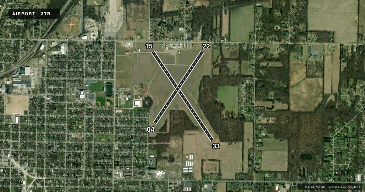
Airport sketch
Runways drawn to scale from FAA survey coordinates, rendered over satellite imagery. Not for navigation.
Approaches & charts
Services on the field
Fuel grades, oxygen, maintenance, ramp storage and lighting — as declared to the FAA by the airport operator.
Fuel & services
- Fuel
- 100LL
- Oxygen (bottled)
- Not available
- Oxygen (bulk)
- Not available
- Airframe repair
- Not available
- Power plant repair
- Not available
- Other services
- AGRI,CHTR
Ramp & ground
- Transient storage
- Tie-down
- Landing fee
- No fee published
- Customs
- Not available
- Lighting schedule
- SEE RMK
- Beacon schedule
- SS-SR
- Beacon
- White / Green (civil land)(WG)
- Wind indicator
- Lighted
- Segmented circle
- Yes
Fuel & FBOs
Cheapest 100LL and Jet A on the field and nearby. Always confirm with the FBO before taxi.
Airport notes
Surface conditions, obstructions, local procedures, lighting outages and other notes published with each FAA cycle.
General notes
- RWY 15 TRSN ZONE +51 FT OBSTN, LGTD POLES.
- GCO AVBL ON FREQ 121.725 THRU SBN CD & FLT SVCS.
- FOR CD IF UNA VIA GCO CTC SOUTH BEND APCH AT 574-251-2609. WHEN SOUTH BEND APCH CLSD, FOR CD CTC CHICAGO ARTCC AT 630-906-8921.
- DEER & LRG BIRDS ON & INVOF ARPT.
Lighting notes
- ACTVT REIL RWY 15 & 33; PAPI RWY 15 & 33; MIRL RWY 15/33 - CTAF.
Fuel notes
- 100LLSELF SVC FUEL.
Approach & departure obstructions
- 04+13 FT TREE, 199 FT DIST, 110 FT L.
- 15+8 FT SEASONAL CROPS, 20 FT DIST, 250 FT L/R.
- 33+8 FT SEASONAL CROPS, 50 FT DIST, 250 FT L/R.
- 15PAPI UNUSBL BYD 5 DEGS LEFT OR RIGHT OF CNTRLN.
- 33PAPI UNUSBL BYD 3 DEGS LEFT OR RIGHT OF CNTRLN.
- 15APCH RATIO 13:1 TO DTHR OVR +62 FT TREE, 836 FT DIST, 250 FT L.
- 22APCH RATIO 16:1 TO DTHR OVR 80 FT TREES, 1320 FT DIST, 255 FT R.
Other notes
- 04/22CRACKED & BROKEN PAVEMENT.
VFR map & nearby airports
VFR sectional. Tap any ICAO chip to open that airport.
Key facts · 3TR
Answer card- ICAO
- 3TR
- Name
- JERRY TYLER MEML
- Location
- NILES, MICHIGAN
- Elevation
- 750.4 ft MSL
- Traffic pattern altitude
- 1,750.4 ft MSL (1,000 AGL)
- Control tower
- Non-towered (use CTAF)
- Total runways
- 2
- Longest runway
- 15/33 · 4,100 ft
- Published ILS approaches
- 0
- Published frequencies
- 4
- Magnetic variation
- 5°
- Current flight rules
- VFR
- Current wind
- 210° at 4 kt
- Favored runway now
- RWY 22
Jerry Tyler Meml Airport sits in Niles, Michigan. Field elevation is 750.4 ft MSL. The airport has two asphalt runways. The longest is runway 15/33 at 4,100 ft. Runway 04/22 is 3,316 ft. There is no control tower. Pattern altitude is not published, so use the standard 1,000 ft AGL for light piston traffic unless the current Chart Supplement says otherwise.
No ILS approaches are published here. Runway 15 has medium intensity lighting, runway end identifier lights and PAPI. Runway 33 also has runway end identifier lights and PAPI. The published remarks call out cracked and broken pavement on 04/22. They also note numerous cracks on 15/33. Trees near the runway environment affect the approach paths. Pay close attention on final. The field also has self-serve 100LL.
Jerry Tyler Memorial Airport is an untowered field, so use CTAF 122.8 for local traffic calls. South Bend Approach handles the published approach frequencies. If you need clearance delivery and ground communications are not available, the Chart Supplement says to contact South Bend Approach or Chicago ARTCC depending on hours. First-time arrivals should plan for a small-field pattern. Watch the runway environment closely. Verify current notes in the Chart Supplement before departure.