METAR & TAF IN6
IN6 does not publish a METAR.
Showing the nearest reporting station: KSBN (SOUTH BEND INTL) · 10.3 NM away. Conditions at IN6 may differ.
METAR · KSBN
Observed 14:54Z
KSBN 261454Z 21004KT 7SM FEW008 25/21 A2995 RMK AO2 SLP136 T02500211 58007
- Wind
- 210° @ 4 kt
- Visibility
- 7 SM
- Temp / Dew
- 25°C / 21°C
- Altimeter
- 29.95 inHg
- Clouds
- FEW
- Density alt
- 2,106 ft
- Ceiling
- Unlimited
- Rules
- VFR
Airport info & contacts
Manager on record, flight service, ARTCC, attendance schedule and pattern altitude — published by the FAA and refreshed every 28 days.
Location
- From city
- 1 NM NW
- VFR sectional
- CHICAGO
- ARTCC
- ZAU · CHICAGO
- NOTAM facility
- HUF
Airport manager
- Name
- KENTON TURNER
- Phone
- 317-232-0935
- Address
- 402 WEST WASHINGTON ST RM W-255D, INDIANAPOLIS IN 46204
Flight service · Hours
- FSS HUF
- TERRE HAUTE1-800-WX-BRIEF
Frequencies
Tap any row to copy the frequency to your clipboard.
Runways & pattern
Full pagePattern entry · RWY 29W
LEFT TRAFFICAirport sketch
Runways drawn to scale from FAA survey coordinates, rendered over satellite imagery. Not for navigation.
Approaches & charts
Services on the field
Fuel grades, oxygen, maintenance, ramp storage and lighting — as declared to the FAA by the airport operator.
Fuel & services
- Fuel
- Not available
Ramp & ground
- Transient storage
- Not published
Fuel & FBOs
Cheapest 100LL and Jet A on the field and nearby. Always confirm with the FBO before taxi.
Airport notes
Surface conditions, obstructions, local procedures, lighting outages and other notes published with each FAA cycle.
VFR map & nearby airports
VFR sectional. Tap any ICAO chip to open that airport.
Key facts · IN6
Answer card- ICAO
- IN6
- Name
- HUDSON LAKE
- Location
- HUDSON LAKE, INDIANA
- Elevation
- 761 ft MSL
- Traffic pattern altitude
- 1,761 ft MSL (1,000 AGL)
- Control tower
- Non-towered (use CTAF)
- Total runways
- 1
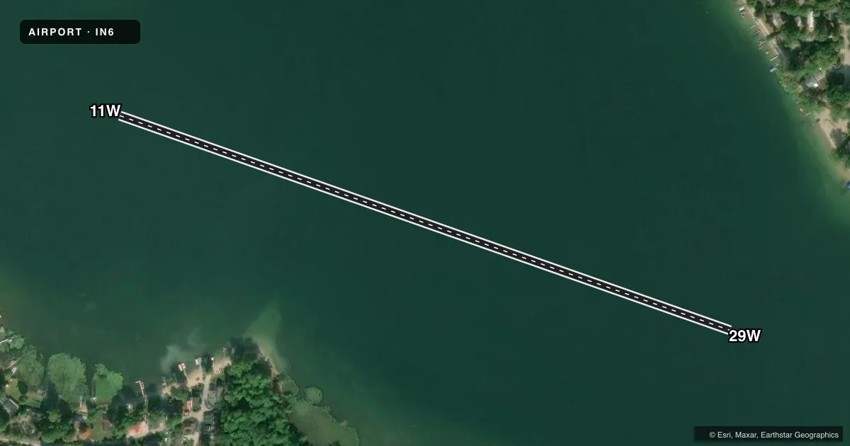
- Longest runway
- 11W/29W · 2,675 ft
- Published ILS approaches
- 0
- Published frequencies
- 1
- Magnetic variation
- –
- Current flight rules
- VFR
- Current wind
- 210° at 4 kt
- Favored runway now
- RWY 29W
Hudson Lake Airport (IN6) sits in Hudson Lake, Indiana. Field elevation is 761 ft MSL. The airport has one runway. It is a 2,675 ft water runway, 11W/29W. There is no control tower. CTAF is 122.9.
No ILS approaches are published here. Pattern altitude is not published in the facts, so use the current Chart Supplement before you fly. The runway headings in the record are magnetic. The field is a water airport. Plan for the normal issues that come with seaplane operations. Check surface conditions. Check local traffic. Check your own performance margins before arrival. There are no on-field FBOs listed in the facts. Contact the airport operator directly or call on CTAF for current services before you go.
For a first visit, the main thing to verify is how the water runway is being used that day. With no tower and no published ILS, this is a see-and-avoid environment. Review the current Chart Supplement for any changes, local procedures, or operating notes before departure.