METAR & TAF KSBN
Current METAR
Observed 17:54Z
KSBN 261754Z 21007KT 10SM FEW024 SCT029 BKN047 29/22 A2993 RMK AO2 SLP129 T02890217 10289 20211 58005
- Wind
- 210° @ 7 kt
- Visibility
- 10 SM
- Temp / Dew
- 29°C / 22°C
- Altimeter
- 29.93 inHg
- Clouds
- BKN
- Density alt
- 2,658 ft
- Ceiling
- 4,700 ft AGL
- Rules
- VFR
Airport info & contacts
Manager on record, flight service, ARTCC, attendance schedule and pattern altitude — published by the FAA and refreshed every 28 days.
Location
- From city
- 3 NM NW
- VFR sectional
- CHICAGO
- ARTCC
- ZAU · CHICAGO
- NOTAM facility
- SBN (NOTAM-D)
Airport manager
- Name
- MICHAEL A. DAIGLE
- Phone
- 574-282-4590
- Address
- 4477 PROGRESS DRIVE, SOUTH BEND IN 46628
Flight service · Hours
- FSS HUF
- TERRE HAUTE1-800-WX-BRIEF
- Attendance
- ALL
Frequencies
Tap any row to copy the frequency to your clipboard.
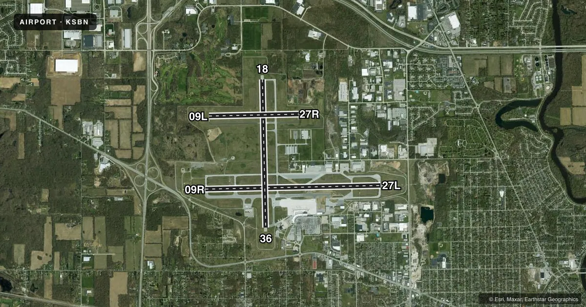
Runways & pattern
Full pagePattern entry · RWY 18
LEFT TRAFFIC| Runway | Heading (°M) | Length | Surface | Traffic |
|---|---|---|---|---|
| 09R/27L | 84° / 264° | 8,412 ft | ASPH | Standard L |
| 18/36Favored | 174° / 354° | 7,101 ft | ASPH | Standard L |
| 09L/27R | 84° / 264° | 4,300 ft | ASPH | Standard L |
Runway end performance
| End | TORA | TODA | ASDA | LDA | VGSI | Approach lights | Obstruction |
|---|---|---|---|---|---|---|---|
| 09R | 8,412' | 8,412' | 8,412' | 8,412' | PAPI 4-box left(3°) | MALSF | 60', tree, 1492' from thr, 666' R of cntrln, slope 21 |
| 27L | 8,412' | 8,412' | 8,412' | 8,412' | PAPI 4-box left(3°) | MALSR | 36', tree, 1741' from thr, 588' R of cntrln, slope 42 |
| 18 | 7,101' | 7,101' | 7,101' | 7,101' | PAPI 4-box left(3°) | — | 69', tree, 2726' from thr, 442' R of cntrln, slope 36 |
| 36 | 7,101' | 7,101' | 7,101' | 7,101' | PAPI 4-box left(3°) | — | 80', tree, 1880' from thr, 210' R of cntrln, slope 20 |
| 09L | — | — | — | — | PAPI 2-box left(3°) | — | 62', tree, 1541' from thr, 93' R of cntrln, slope 21 |
| 27R | — | — | — | — | PAPI 2-box left(3°) | — | 51', tree, 1226' from thr, 368' R of cntrln, slope 20 |
Declared distances in feet. TORA = takeoff run available, TODA = takeoff distance, ASDA = accelerate-stop, LDA = landing distance.
Airport sketch
Runways drawn to scale from FAA survey coordinates, rendered over satellite imagery. Not for navigation.
Approaches & charts
ILS · 2
Services on the field
Fuel grades, oxygen, maintenance, ramp storage and lighting — as declared to the FAA by the airport operator.
Fuel & services
- Fuel
- 100LLA
- Oxygen (bottled)
- HIGH/LOW
- Oxygen (bulk)
- HIGH/LOW
- Airframe repair
- Major
- Power plant repair
- Major
- Other services
- AFRT,CARGO,CHTR,INSTR,RNTL
Ramp & ground
- Transient storage
- Tie-down
- Hangar
- Lighting schedule
- SEE RMK
- Beacon schedule
- SS-SR
- Beacon
- White / Green (civil land)(WG)
- Wind indicator
- Lighted
- Segmented circle
- No
Fuel & FBOs
Cheapest 100LL and Jet A on the field and nearby. Always confirm with the FBO before taxi.
Airport notes
Surface conditions, obstructions, local procedures, lighting outages and other notes published with each FAA cycle.
General notes
- BIRDS ON & INVOF ARPT.
- TWY T NOT AVBL TO ACR OPNS WITH MORE THAN 9 PAX SEATS OR UNSKED ACR AT LEAST 31 PAX SEATS.
- LINE OF SIGHT BTN RWY INTS RSTRD.
- FOR FUEL & SVCS - 122.95 OR 131.7.
- FOR CD CTC SOUTH BEND APCH AT 574-251-2609. WHEN SOUTH BEND APCH CLSD, FOR CD CTC CHICAGO ARTCC AT 630-906-8921.
- ACR RAMP RSTRD TO SKED COML & WINGSPAN GTR THAN 100 FT; ALL OTR 24 HR PPR.
- INDEX C AVAILABLE UPON REQ
- TWYS J, J1 & J2 CLSD INDEF.
Lighting notes
- WHEN ATCT CLSD, TO INCR INTST AND ACTVT MALSF RWY 09R; MALSR RWY 27L; HIRL RWY 09R/27L; MIRL RWY 18/36 AND ALL TWYS - CTAF.
Runway surface & condition
- 09L/27RPCR VALUE: 430/F/B/X/T
- 09R/27LPCR VALUE: 410/F/B/X/U
- 18/36PCR VALUE: 450/F/B/X/T
- 09L/27RRWY 09L/27R NOT AVBL FOR PART 121/PART 380 OPS WITH SKED PAX CARRYING OPS MORE THAN 9 PAX SEATS AND NON-SKED PAX CARRYING OPS MORE THAN 30 PAX SEATS. CLSD WHEN TWR CLSD; WT RSTRD 45000 SINGLE & 60000 DUAL.
Approach & departure obstructions
- 27RAPCH SLOPE 21:1 DUE TO 92 FT HIGH TENSION WIRES 2160 FT FM RWY END; 394 FT R OF CNTRLN.
- 27RBE ALERT DURG RIGHT BASE; HIGH TENSION WIRES AER.
Other notes
- 24 HR PPR FOR CBP - 574-232-9650; WKEND SVC CALL BFR 1600 FRI.
VFR map & nearby airports
VFR sectional. Tap any ICAO chip to open that airport.
Key facts · KSBN
Answer card- ICAO
- KSBN
- Name
- SOUTH BEND INTL
- Location
- SOUTH BEND, INDIANA
- Elevation
- 798.4 ft MSL
- Traffic pattern altitude
- 1,798.4 ft MSL (1,000 AGL)
- Control tower
- Towered · 0530-0000 SUN-FRI, 0530-2345 SAT.
- Total runways
- 3
- Longest runway
- 09R/27L · 8,412 ft
- Published ILS approaches
- 2
- Published frequencies
- 13
- Magnetic variation
- 5°
- Current flight rules
- VFR
- Current wind
- 210° at 7 kt
- Favored runway now
- RWY 18
South Bend Intl is in South Bend, Indiana. The field elevation is 798.4 ft MSL. It has three asphalt runways. The longest is 8,412 ft on 09R/27L. South Bend has a control tower. Tower hours are 0530-0000 Sunday through Friday. Saturday hours are 0530-2345.
Two ILS approaches are published. They serve runway ends 09R and 27L. The pattern altitude is not published in the facts, so use the standard 1,000 ft AGL for light piston unless the current Chart Supplement says otherwise. The airport sits in Class C airspace. Clearance delivery is handled by South Bend Approach when it is open. If Approach is closed, use Chicago ARTCC for clearance delivery.
Signature Aviation is on the field. It carries 100LL, Jet A and Jet A Prist. Atlantic Aviation is also on the field. It carries 100LL and Jet A. Runway 09L/27R has published limits. It is not available for certain scheduled passenger operations. It is also closed when the tower is closed. The field has bird activity in and around the airport. If you are flying a larger aircraft, check the ramp and taxiway limits before you go. The published remarks also call out high tension wires near the 27R approach path. Brief that side carefully.