METAR & TAF C91
C91 does not publish a METAR.
Showing the nearest reporting station: KBEH (SOUTHWEST MICHIGAN RGNL) · 15.5 NM away. Conditions at C91 may differ.
METAR · KBEH
Observed 17:53Z
KBEH 261753Z AUTO 27009KT 10SM CLR 28/23 A2992 RMK AO2 SLP127 T02780228 10283 20211 56004
- Wind
- 270° @ 9 kt
- Visibility
- 10 SM
- Temp / Dew
- 28°C / 23°C
- Altimeter
- 29.92 inHg
- Clouds
- CLR
- Density alt
- 2,487 ft
- Ceiling
- Unlimited
- Rules
- VFR
Airport info & contacts
Manager on record, flight service, ARTCC, attendance schedule and pattern altitude — published by the FAA and refreshed every 28 days.
Location
- From city
- 1 NM NW
- VFR sectional
- CHICAGO
- Pattern altitude
- 800 ft AGL · 1,547 ft MSL
- ARTCC
- ZAU · CHICAGO
- NOTAM facility
- LAN (NOTAM-D)
Airport manager
- Name
- OSCAR AZEVEDO
- Phone
- 269-591-0054
- Address
- 241 S. FRONT ST., 241 S FRONT ST, DOWAGIAC MI 49047-1738
Flight service · Hours
- FSS LAN
- LANSING1-800-WX-BRIEF
- Attendance
- Unattended
Frequencies
Tap any row to copy the frequency to your clipboard.
Runways & pattern
Full pagePattern entry · RWY 27
RIGHT TRAFFIC| Runway | Heading (°M) | Length | Surface | Traffic |
|---|---|---|---|---|
| 09/27Favored | 85° / 265° | 4,700 ft | ASPH | 27 R |
| 04/22 | 39° / 219° | 2,176 ft | TURF | 22 R |
Runway end performance
| End | TORA | TODA | ASDA | LDA | VGSI | Approach lights | Obstruction |
|---|---|---|---|---|---|---|---|
| 09 | — | — | — | — | PAPI 4-box left(3°) | — | 54', tree, 930' from thr, 320' R of cntrln, slope 13 |
| 27 | — | — | — | — | PAPI 4-box left(3°) | — | 60', trees, 947' from thr, 266' R of cntrln, slope 12 |
| 04 | — | — | — | — | — | — | 65', tree, 1042' from thr, 255' R of cntrln, slope 16 |
| 22 | — | — | — | — | — | — | 81', tree, 921' from thr, 231' R of cntrln, slope 11 |
Declared distances in feet. TORA = takeoff run available, TODA = takeoff distance, ASDA = accelerate-stop, LDA = landing distance.
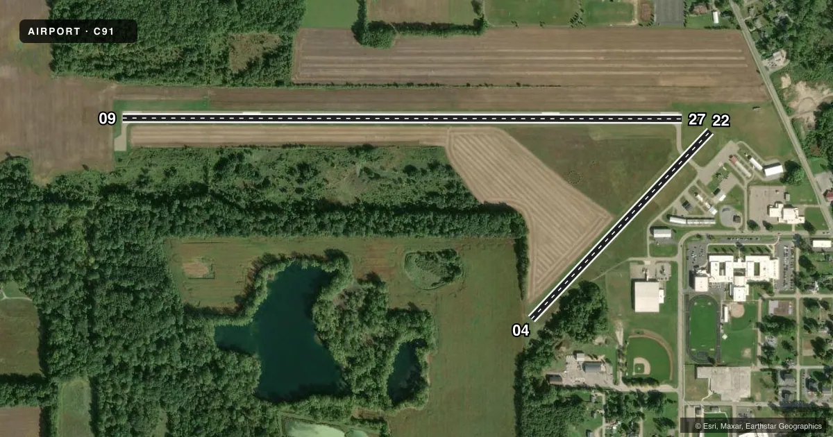
Airport sketch
Runways drawn to scale from FAA survey coordinates, rendered over satellite imagery. Not for navigation.
Approaches & charts
Services on the field
Fuel grades, oxygen, maintenance, ramp storage and lighting — as declared to the FAA by the airport operator.
Fuel & services
- Fuel
- 100LL
- Other services
- INSTR,RNTL
Ramp & ground
- Transient storage
- Tie-down
- Landing fee
- No fee published
- Customs
- Not available
- Lighting schedule
- SEE RMK
- Beacon schedule
- SS-SR
- Beacon
- White / Green (civil land)(WG)
- Wind indicator
- Lighted
- Segmented circle
- Yes
Fuel & FBOs
Cheapest 100LL and Jet A on the field and nearby. Always confirm with the FBO before taxi.
Airport notes
Surface conditions, obstructions, local procedures, lighting outages and other notes published with each FAA cycle.
General notes
- DEER & LRG BIRDS ON & INVOF ARPT.
- MODEL R/C ACFT OPS E SIDE OF RWY 04/22.
- ADMIN BLDG ACCESS, DEPRESS V, THEN III-II SIMULTANEOUS, THEN I.
- FOR CD CTC SOUTH BEND APCH AT 574-251-2609. WHEN SOUTH BEND APCH CLSD, FOR CD CTC CHICAGO ARTCC AT 630-906-8921.
Lighting notes
- ACTVT MIRL RWY 09/27; PAPI RWYS 09 & RWY 27; & REIL RWYS 09 & 27 - CTAF.
Fuel notes
- 100LLSELF SVC FUEL AVBL 24 HR.
Approach & departure obstructions
- 09+2 FT CROPS, 2 FT TALL, 75 DIST, 250 L & R.
- 04RWY 04/22 & RWY 22 DSPLCD THR MKD WITH 3 FT YELLOW CONES.
- 22APCH RATIO 20:1 AT DSLPD THR.
VFR map & nearby airports
VFR sectional. Tap any ICAO chip to open that airport.
Key facts · C91
Answer card- ICAO
- C91
- Name
- DOWAGIAC MUNI
- Location
- DOWAGIAC, MICHIGAN
- Elevation
- 747.3 ft MSL
- Traffic pattern altitude
- 1,547.3 ft MSL (800 AGL)
- Control tower
- Non-towered (use CTAF)
- Total runways
- 2
- Longest runway
- 09/27 · 4,700 ft
- Published ILS approaches
- 0
- Published frequencies
- 4
- Magnetic variation
- 5°
- Current flight rules
- VFR
- Current wind
- 270° at 9 kt
- Favored runway now
- RWY 27
Dowagiac Muni is in Dowagiac, Michigan. The field elevation is 747.3 ft MSL. It has two runways. The longest is runway 09/27 at 4,700 ft asphalt. Runway 04/22 is 2,176 ft turf. There is no control tower. Pattern altitude is 800 ft AGL, which is 1,547.3 ft MSL.
No ILS approaches are published here. For IFR work, pilots should plan around the current FAA Chart Supplement and coordinate with South Bend Approach as needed. Published remarks also note displaced thresholds on runway 04/22 and runway 22. They also note a 20:1 approach ratio at the displaced threshold. There are 2-foot crops near runway 09, so pay attention on short final and during rollout.
Dowagiac Municipal Airport is the on-field FBO. It carries 100LL. Self-serve fuel is available 24 hours. The field also has medium intensity runway lights on 09/27, PAPI on 09 and 27 and REIL on 09 and 27 that operate on CTAF. Deer and large birds are reported in the area. Model remote control aircraft operations occur on the east side of runway 04/22. First-time pilots should brief the turf runway, the wildlife and the displaced threshold markings before arrival.