METAR & TAF 2C5
2C5 does not publish a METAR.
Showing the nearest reporting station: KAZO (KALAMAZOO/BATTLE CREEK INTL) · 13.4 NM away. Conditions at 2C5 may differ.
METAR · KAZO
Observed 20:53Z
KAZO 252053Z 21006G15KT 10SM FEW046 28/15 A2997 RMK AO2 SLP147 T02780150 56019
- Wind
- 210° @ 6G15 kt
- Visibility
- 10 SM
- Temp / Dew
- 28°C / 15°C
- Altimeter
- 29.97 inHg
- Clouds
- FEW
- Density alt
- 2,426 ft
- Ceiling
- Unlimited
- Rules
- VFR
Airport info & contacts
Manager on record, flight service, ARTCC, attendance schedule and pattern altitude — published by the FAA and refreshed every 28 days.
Location
- From city
- 3 NM NE
- VFR sectional
- CHICAGO
- ARTCC
- ZAU · CHICAGO
- NOTAM facility
- LAN (NOTAM-D)
Airport manager
- Name
- SHERI MANNING
- Phone
- 269-657-2346
- Address
- 45872 30TH ST, PAW PAW MI 49079-8004
Flight service · Hours
- FSS LAN
- LANSING1-800-WX-BRIEF
- Attendance
- Unattended
Frequencies
Tap any row to copy the frequency to your clipboard.
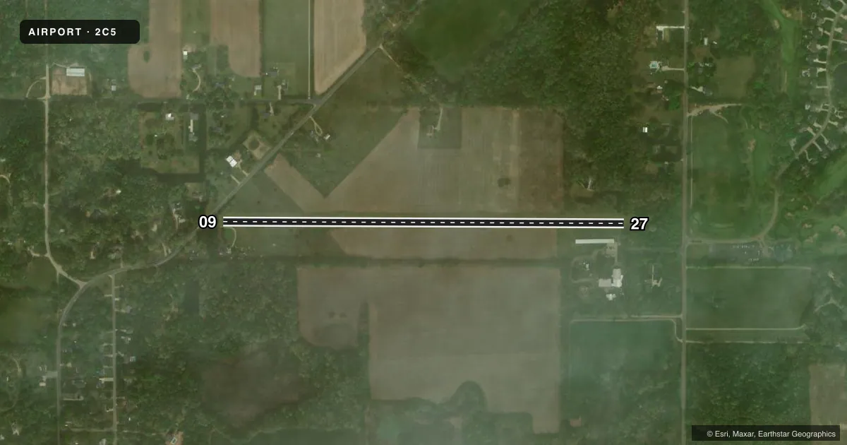
Runways & pattern
Full pagePattern entry · RWY 27
LEFT TRAFFICRunway end performance
| End | TORA | TODA | ASDA | LDA | VGSI | Approach lights | Obstruction |
|---|---|---|---|---|---|---|---|
| 09 | — | — | — | — | — | — | 35', tree, 0' from thr, 70' R of cntrln, slope 0 |
| 27 | — | — | — | — | — | — | 68', tree, 40' from thr, 73' R of cntrln, slope 0 |
Declared distances in feet. TORA = takeoff run available, TODA = takeoff distance, ASDA = accelerate-stop, LDA = landing distance.
Airport sketch
Runways drawn to scale from FAA survey coordinates, rendered over satellite imagery. Not for navigation.
Approaches & charts
Services on the field
Fuel grades, oxygen, maintenance, ramp storage and lighting — as declared to the FAA by the airport operator.
Fuel & services
- Fuel
- Not available
- Oxygen (bottled)
- Not available
- Oxygen (bulk)
- Not available
- Airframe repair
- Not available
- Power plant repair
- Not available
- Other services
- AGRI
Ramp & ground
- Transient storage
- Tie-down
- Landing fee
- No fee published
- Wind indicator
- Yes
- Segmented circle
- No
Fuel & FBOs
Cheapest 100LL and Jet A on the field and nearby. Always confirm with the FBO before taxi.
Airport notes
Surface conditions, obstructions, local procedures, lighting outages and other notes published with each FAA cycle.
General notes
- DEER & LRG BIRDS ON & INVOF ARPT.
- ARPT CLSD DEC-MAR & WHEN SNOW COVD.
- FOR CD CTC GREAT LAKES APCH AT 269-459-3344, WHEN APCH CLSD CTC CHICAGO ARTCC AT 630-906-8921.
- FOR FICONS CTC AMGR.
Approach & departure obstructions
- 09RWY & DTHR MKD WITH 3 FT YELLOW CONES.
- 27RWY & DTHR MKD WITH 3 FT YELLOW CONES.
- 09APCH RATIO 12:1 TO DTHR OVR 82 FT TREES, 1008 FT DIST, 70 FT R; 16:1 BASED ON STRAIGHT OUT OVR 74 FT TREES, 1212 FT DIST.
- 27APCH RATIO 13:1 TO DTHR OVR 96 FT TREES, 1254 FT DIST, 115 FT R; 16:1 BASED ON STRAIGHT OUT OVR 86 FT TREES, 1422 FT DIST.
- 09ALSO 65 FT TREES, 40 FT DIST, 73 FT R.
Other notes
- DTRMN PENDING.
- MANAGERCELL 269-207-2743.
VFR map & nearby airports
VFR sectional. Tap any ICAO chip to open that airport.
Key facts · 2C5
Answer card- ICAO
- 2C5
- Name
- ALMENA
- Location
- PAW PAW, MICHIGAN
- Elevation
- 748 ft MSL
- Traffic pattern altitude
- 1,748 ft MSL (1,000 AGL)
- Control tower
- Non-towered (use CTAF)
- Total runways
- 1
- Longest runway
- 09/27 · 3,300 ft
- Published ILS approaches
- 0
- Published frequencies
- 1
- Magnetic variation
- 3°
- Current flight rules
- VFR
- Current wind
- 210° at 6 kt
- Favored runway now
- RWY 27
Almena Airport (2C5) sits in Paw Paw, Michigan. Field elevation is 748 ft MSL. It has one runway, 09/27 and the longest runway is 3,300 ft of turf. There is no control tower. CTAF is 122.9. No ILS approaches are published here.
Pattern altitude is not published. Use the standard 1,000 ft AGL for light piston traffic unless the current Chart Supplement says otherwise. With the field at 748 ft MSL, that puts a typical pattern around 1,748 ft MSL. The airport is closed December through March and when snow covered. That matters here because turf and winter conditions can change the field fast.
Published remarks also call out deer and large birds on and near the airport. Runway and displaced threshold markings use 3 foot yellow cones. There are tree obstructions on both ends, so plan your approach carefully and verify current field conditions before you go. For clearance delivery, contact Great Lakes Approach at 269-459-3344. When Approach is closed, contact Chicago ARTCC at 630-906-8921. No on-field FBOs are listed, so call the airport operator directly or use CTAF for current local info before arrival.