METAR & TAF KLWA
Current METAR
Observed 11:55Z
KLWA 271155Z AUTO 10011G14KT 5SM -RA BR OVC005 25/23 A2990 RMK AO2 PRESRR 10253 20240 70000
- Wind
- 100° @ 11G14 kt
- Visibility
- 5 SM
- Temp / Dew
- 25°C / 23°C
- Altimeter
- 29.90 inHg
- Clouds
- OVC
- Density alt
- 2,050 ft
- Ceiling
- 500 ft AGL
- Rules
- IFR
Airport info & contacts
Manager on record, flight service, ARTCC, attendance schedule and pattern altitude — published by the FAA and refreshed every 28 days.
Location
- From city
- 3 NM S
- VFR sectional
- CHICAGO
- ARTCC
- ZAU · CHICAGO
- NOTAM facility
- LWA (NOTAM-D)
Airport manager
- Name
- DAN SANBORN
- Phone
- 269-348-2222
- Address
- 73020 COUNTY ROAD 380, SOUTH HAVEN MI 49090-9441
Flight service · Hours
- FSS LAN
- LANSING1-800-WX-BRIEF
- Attendance
- 0900-1700
Frequencies
Tap any row to copy the frequency to your clipboard.
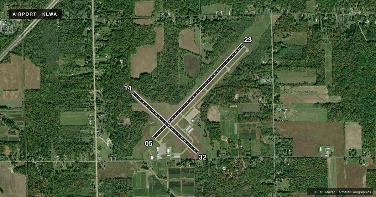
Runways & pattern
Full pagePattern entry · RWY 14
LEFT TRAFFIC| Runway | Heading (°M) | Length | Surface | Traffic |
|---|---|---|---|---|
| 05/23 | 41° / 221° | 4,800 ft | ASPH | Standard L |
| 14/32Favored | 130° / 310° | 3,260 ft | TURF | Standard L |
Runway end performance
| End | TORA | TODA | ASDA | LDA | VGSI | Approach lights | Obstruction |
|---|---|---|---|---|---|---|---|
| 05 | — | — | — | — | PAPI 4-box left(3.5°) | — | 60', tree, 1395' from thr, 280' R of cntrln, slope 19 |
| 23 | — | — | — | — | PAPI 4-box left(3.5°) | — | 22', trees, 505' from thr, 280' R of cntrln, slope 13 |
| 14 | — | — | — | — | — | — | 78', trees, 10' from thr, 110' R of cntrln, slope 0 |
| 32 | — | — | — | — | — | — | 50', tree, 235' from thr, 148' R of cntrln, slope 4 |
Declared distances in feet. TORA = takeoff run available, TODA = takeoff distance, ASDA = accelerate-stop, LDA = landing distance.
Airport sketch
Runways drawn to scale from FAA survey coordinates, rendered over satellite imagery. Not for navigation.
Approaches & charts
Services on the field
Fuel grades, oxygen, maintenance, ramp storage and lighting — as declared to the FAA by the airport operator.
Fuel & services
- Fuel
- 100LLA+
- Oxygen (bottled)
- Not available
- Oxygen (bulk)
- Not available
- Airframe repair
- Major
- Power plant repair
- Major
- Other services
- AGRI
Ramp & ground
- Transient storage
- Tie-down
- Hangar
- Landing fee
- No fee published
- Customs
- Not available
- Lighting schedule
- SEE RMK
- Beacon schedule
- SS-SR
- Beacon
- White / Green (civil land)(WG)
- Wind indicator
- Lighted
- Segmented circle
- Yes
Fuel & FBOs
Cheapest 100LL and Jet A on the field and nearby. Always confirm with the FBO before taxi.
Airport notes
Surface conditions, obstructions, local procedures, lighting outages and other notes published with each FAA cycle.
General notes
- DEER & LRG BIRDS ON & INVOF ARPT.
- AG OPS SUMMER MONTHS.
- ADMIN BLDG ACES: PRESS 5, THEN 3 & 2 SIMUL, THEN 1.
- FOR AFT HRS FICONS CALL AMGR CELL 269-348-2222.
- CK LCL CONDS BFR USE OF TURF RWY 14/32 - CALL AMGR.
- FOR CD CTC SOUTH BEND APCH AT 574-251-2609. WHEN SOUTH BEND APCH CLSD, FOR CD CTC CHICAGO ARTCC AT 630-906-8921.
Lighting notes
- ACTVT OR INCR INTST REIL RWY 05 & 23; MIRL RWY 05/23 - CTAF. PAPI RWY 05 & 23 OPR CONSLY; MIRL RWY 05/23 PRESET LOW INTST DUSK-2300.
Approach & departure obstructions
- 14DTHR MKD WITH 3 FT YELLOW CONES, 3 EACH SIDE.
- 32DTHR MKD WITH 3 FT YELLOW CONES, 3 EACH SIDE.
- 14APCH RATIO 12:1 TO DTHR OVR 78 FT TREES, 966 FT DIST, 110 FT L.
Other notes
- MANAGERCELL 269-348-2222.
VFR map & nearby airports
VFR sectional. Tap any ICAO chip to open that airport.
Key facts · KLWA
Answer card- ICAO
- KLWA
- Name
- SOUTH HAVEN AREA RGNL
- Location
- SOUTH HAVEN, MICHIGAN
- Elevation
- 665.5 ft MSL
- Traffic pattern altitude
- 1,665.5 ft MSL (1,000 AGL)
- Control tower
- Non-towered (use CTAF)
- Total runways
- 2
- Longest runway
- 05/23 · 4,800 ft
- Published ILS approaches
- 0
- Published frequencies
- 4
- Magnetic variation
- 3°
- Current flight rules
- IFR
- Current wind
- 100° at 11 kt
- Favored runway now
- RWY 14
South Haven Area Rgnl Airport (KLWA) sits in South Haven, Michigan at 665.5 ft MSL. It has two runways. The longest is 05/23 at 4,800 ft asphalt. Runway 14/32 is 3,260 ft turf. There is no control tower. CTAF and UNICOM are both 122.8. South Bend Approach is the published approach and departure point on 118.55 and 257.8. No ILS approaches are published.
Pattern altitude is not published. Use the standard 1,000 ft AGL for light piston traffic unless the current Chart Supplement says otherwise. That puts the pattern at about 1,665.5 ft MSL based on the field elevation. Runway 05 and 23 have runway end identifier lights. The 05/23 lights are medium intensity and CTAF controlled. PAPI is listed for runways 05 and 23. The turf runway 14/32 should be checked with the airport manager before use. Published remarks also call out trees near the displaced threshold on 14. Deer, large birds and summer agricultural activity are part of the local picture. The airport manager can also be reached after hours at 269-348-2222. South Haven Area Regional Airport is the on-field FBO. It carries AVGAS 100LL and Jet A.