METAR & TAF KBIV
Current METAR
Observed 22:53Z
KBIV 252253Z AUTO 25009KT 10SM CLR 24/16 A2997 RMK AO2 SLP144 T02440161
- Wind
- 250° @ 9 kt
- Visibility
- 10 SM
- Temp / Dew
- 24°C / 16°C
- Altimeter
- 29.97 inHg
- Clouds
- CLR
- Density alt
- 1,883 ft
- Ceiling
- Unlimited
- Rules
- VFR
Airport info & contacts
Manager on record, flight service, ARTCC, attendance schedule and pattern altitude — published by the FAA and refreshed every 28 days.
Location
- From city
- 2 NM S
- VFR sectional
- CHICAGO
- ARTCC
- ZAU · CHICAGO
- NOTAM facility
- BIV (NOTAM-D)
Airport manager
- Name
- MATTHEW NEYENS
- Phone
- 616-414-0726
- Address
- 60 GEURINK BLVD, HOLLAND MI 49423-7847
Flight service · Hours
- FSS LAN
- LANSING1-800-WX-BRIEF
- Attendance
- MON-FRI · 0600-2200
- SAT-SUN · 0700-2100
Frequencies
Tap any row to copy the frequency to your clipboard.
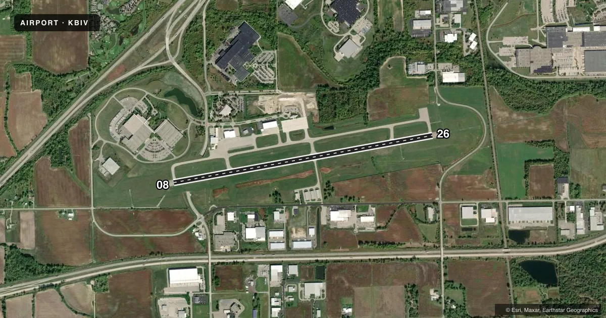
Runways & pattern
Full pagePattern entry · RWY 26
LEFT TRAFFICRunway end performance
| End | TORA | TODA | ASDA | LDA | VGSI | Approach lights | Obstruction |
|---|---|---|---|---|---|---|---|
| 08 | — | — | — | — | PAPI 4-box left(3°) | — | 6', tree, 280' from thr, 494' R of cntrln, slope 13 |
| 26 | — | — | — | — | PAPI 4-box left(3°) | MALSR | 37', tree, 1297' from thr, 576' R of cntrln, slope 29 |
Declared distances in feet. TORA = takeoff run available, TODA = takeoff distance, ASDA = accelerate-stop, LDA = landing distance.
Airport sketch
Runways drawn to scale from FAA survey coordinates, rendered over satellite imagery. Not for navigation.
Approaches & charts
ILS · 1
Services on the field
Fuel grades, oxygen, maintenance, ramp storage and lighting — as declared to the FAA by the airport operator.
Fuel & services
- Fuel
- 100LLA+
- Oxygen (bottled)
- Not available
- Oxygen (bulk)
- HIGH/LOW
- Airframe repair
- Major
- Power plant repair
- Major
- Other services
- CHTR,INSTR,RNTL
Ramp & ground
- Transient storage
- Tie-down
- Hangar
- Landing fee
- Yes
- Customs
- Not available
- Lighting schedule
- SEE RMK
- Beacon schedule
- SS-SR
- Beacon
- White / Green (civil land)(WG)
- Wind indicator
- Lighted
- Segmented circle
- Yes
Fuel & FBOs
Cheapest 100LL and Jet A on the field and nearby. Always confirm with the FBO before taxi.
Airport notes
Surface conditions, obstructions, local procedures, lighting outages and other notes published with each FAA cycle.
General notes
- RADIO CALL, "HOLLAND."
- FOR CD WHEN GREAT LAKES APCH CLSD CTC CHICAGO ARTCC AT 630-906-8921.
Lighting notes
- ACTVT OR INCR INTST MALSR RWY 26; REIL RWY 08; PAPI RWY 08 & 26; HIRL RWY 08/26 - CTAF. HIRL RWY 08/26 PRESET LOW INTST.
Other notes
- TSNT ACFT CALL AHD FOR HNGR STORAGE.
- 1FOR ARPT ATNDNC & DURG EMERG CALL 616-392-7831.
- MANAGERCELL 248-410-1402.
VFR map & nearby airports
VFR sectional. Tap any ICAO chip to open that airport.
Key facts · KBIV
Answer card- ICAO
- KBIV
- Name
- WEST MICHIGAN RGNL
- Location
- HOLLAND, MICHIGAN
- Elevation
- 697.9 ft MSL
- Traffic pattern altitude
- 1,697.9 ft MSL (1,000 AGL)
- Control tower
- Non-towered (use CTAF)
- Total runways
- 1
- Longest runway
- 08/26 · 6,002 ft
- Published ILS approaches
- 1
- Published frequencies
- 5
- Magnetic variation
- 4°
- Current flight rules
- VFR
- Current wind
- 250° at 9 kt
- Favored runway now
- RWY 26
West Michigan Rgnl sits in Holland, Michigan. The field elevation is 697.9 ft MSL. It has one runway, 08/26, which is 6,002 ft long and paved with asphalt. There is no control tower. The airport uses the call sign "Holland." The published pattern altitude is not listed, so plan on the standard 1,000 ft AGL for light piston traffic unless the current Chart Supplement says otherwise.
The airport has one ILS approach to runway 26. That matters if the weather starts to come down on the lakeshore. Avflight Holland is the on-field FBO. It carries 100LL and Jet A. Transient aircraft must call ahead for hangar storage. For airport attendance and emergencies, use the published airport phone number. Clearance delivery is on 123.95. Great Lakes Approach and Departure are on 133.825 and 290.35. CTAF and UNICOM are both 123.05.
The published remarks also note that runway 08 and 26 lighting is tied to CTAF. The high intensity runway lights are preset to low intensity. If you are new to the field, verify the current Chart Supplement for any local procedures before arrival. That is especially smart here because the airport sits near the Lake Michigan shoreline. Weather can change fast. Low ceilings can affect the ILS runway quickly.