METAR & TAF 3GM
3GM does not publish a METAR.
Showing the nearest reporting station: KMKG (MUSKEGON COUNTY) · 8.2 NM away. Conditions at 3GM may differ.
METAR · KMKG
Observed 05:55Z
KMKG 270555Z AUTO 19005KT 10SM CLR 23/21 A2983 RMK AO2 VIS 1 RWY 14 SLP098 60000 T02280206 10256 20217 58005 $
- Wind
- 190° @ 5 kt
- Visibility
- 10 SM
- Temp / Dew
- 23°C / 21°C
- Altimeter
- 29.83 inHg
- Clouds
- CLR
- Density alt
- 1,820 ft
- Ceiling
- Unlimited
- Rules
- VFR
Airport info & contacts
Manager on record, flight service, ARTCC, attendance schedule and pattern altitude — published by the FAA and refreshed every 28 days.
Location
- From city
- 2 NM SE
- VFR sectional
- CHICAGO
- ARTCC
- ZAU · CHICAGO
- NOTAM facility
- LAN (NOTAM-D)
Airport manager
- Name
- EARLE BARES
- Phone
- 616-842-4430
- Address
- 16446 COMSTOCK ST, GRAND HAVEN MI 49417-9423
Flight service · Hours
- FSS LAN
- LANSING1-800-WX-BRIEF
- Attendance
- 0900-1700
Frequencies
Tap any row to copy the frequency to your clipboard.
Runways & pattern
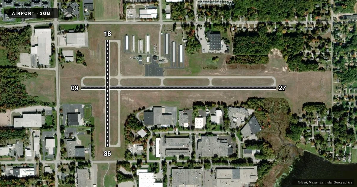
Full pagePattern entry · RWY 18
LEFT TRAFFIC| Runway | Heading (°M) | Length | Surface | Traffic |
|---|---|---|---|---|
| 09/27 | 85° / 265° | 3,752 ft | ASPH | Standard L |
| 18/36Favored | 175° / 355° | 2,058 ft | ASPH | Standard L |
Runway end performance
| End | TORA | TODA | ASDA | LDA | VGSI | Approach lights | Obstruction |
|---|---|---|---|---|---|---|---|
| 09 | — | — | — | — | PAPI 2-box left(3°) | — | 45', trees, 941' from thr, 300' R of cntrln, slope 16 |
| 27 | — | — | — | — | PAPI 2-box left(4°) | — | 45', tree, 675' from thr, 321' R of cntrln, slope 10 |
| 18 | — | — | — | — | — | — | 15', road, 330' from thr, 138' R of cntrln, slope 8 |
| 36 | — | — | — | — | — | — | 11', road, 285' from thr, 134' R of cntrln, slope 7 |
Declared distances in feet. TORA = takeoff run available, TODA = takeoff distance, ASDA = accelerate-stop, LDA = landing distance.
Airport sketch
Runways drawn to scale from FAA survey coordinates, rendered over satellite imagery. Not for navigation.
Approaches & charts
Services on the field
Fuel grades, oxygen, maintenance, ramp storage and lighting — as declared to the FAA by the airport operator.
Fuel & services
- Fuel
- 100LLA
- Airframe repair
- Major
- Power plant repair
- Major
- Other services
- PAJA
Ramp & ground
- Transient storage
- Tie-down
- Hangar
- Landing fee
- No fee published
- Customs
- Not available
- Lighting schedule
- SEE RMK
- Beacon schedule
- SS-SR
- Beacon
- White / Green (civil land)(WG)
- Wind indicator
- Lighted
- Segmented circle
- Yes
Fuel & FBOs
Cheapest 100LL and Jet A on the field and nearby. Always confirm with the FBO before taxi.
Airport notes
Surface conditions, obstructions, local procedures, lighting outages and other notes published with each FAA cycle.
General notes
- UAS OPS WEST OF RWY 18 & NORTH OF RWY 09.
- DEER & LRG BIRDS ON & INVOF ARPT.
- PAJA SFC-14000 FT DLY SR-SS APR-OCT.
- FOR CD CTC GREAT LAKES APCH AT 269-459-3344, WHEN APCH CLSD CTC CHICAGO ARTCC AT 630-906-8921.
- LRG VEHICLE TFC ON ROADS IN RWY 18 & 36 APCH AREAS.
Lighting notes
- ACTVT REIL RWY 09 & 27; PAPI RWY 09 & 27; MIRL RWY 09/27 & 18/36 - CTAF.
Other notes
- 1UNATNDD MAJOR HOLS. FOR SVC & FLD CONDS AFT HRS CALL AMGR CELL.
- MANAGERCELL 616-847-0638.
VFR map & nearby airports
VFR sectional. Tap any ICAO chip to open that airport.
Key facts · 3GM
Answer card- ICAO
- 3GM
- Name
- GRAND HAVEN MEML AIRPARK
- Location
- GRAND HAVEN, MICHIGAN
- Elevation
- 603.8 ft MSL
- Traffic pattern altitude
- 1,603.8 ft MSL (1,000 AGL)
- Control tower
- Non-towered (use CTAF)
- Total runways
- 2
- Longest runway
- 09/27 · 3,752 ft
- Published ILS approaches
- 0
- Published frequencies
- 4
- Magnetic variation
- 5°
- Current flight rules
- VFR
- Current wind
- 190° at 5 kt
- Favored runway now
- RWY 18
Grand Haven Meml Airpark is in Grand Haven, Michigan. Field elevation is 603.8 ft MSL. The airport has two asphalt runways. The longest is runway 09/27 at 3,752 ft. Runway 18/36 is 2,058 ft. There is no control tower, so plan to self-announce on CTAF 122.7 and coordinate with UNICOM on the same frequency.
No ILS approaches are published here. The pattern altitude is not published in the facts, so use the standard 1,000 ft AGL for light piston operations unless the current FAA Chart Supplement says otherwise. E2 Technologies is on the field. It carries 100LL and Jet A. If you need current service details, call them at (616) 842-4430 before arrival.
The published remarks matter here. Runway 09 and 27 have runway end identifier lights, PAPI and medium intensity runway lights that are controlled by CTAF. The airport also has partial airspace surface to 14,000 ft from sunrise to sunset daily from April through October. Deer, large birds and unmanned aircraft operations west of runway 18 and north of runway 09 are all worth watching for. Large vehicle traffic also occurs near the runway 18 and 36 approach areas. For clearance delivery, contact Great Lakes Approach. If approach is closed, use Chicago ARTCC. The field is unattended on major holidays, so check service status before you go.