METAR & TAF Z98
Z98 does not publish a METAR.
Showing the nearest reporting station: KBIV (WEST MICHIGAN RGNL) · 9.1 NM away. Conditions at Z98 may differ.
METAR · KBIV
Observed 22:53Z
KBIV 252253Z AUTO 25009KT 10SM CLR 24/16 A2997 RMK AO2 SLP144 T02440161
- Wind
- 250° @ 9 kt
- Visibility
- 10 SM
- Temp / Dew
- 24°C / 16°C
- Altimeter
- 29.97 inHg
- Clouds
- CLR
- Density alt
- 1,955 ft
- Ceiling
- Unlimited
- Rules
- VFR
Airport info & contacts
Manager on record, flight service, ARTCC, attendance schedule and pattern altitude — published by the FAA and refreshed every 28 days.
Location
- From city
- 3 NM E
- VFR sectional
- CHICAGO
- ARTCC
- ZAU · CHICAGO
- NOTAM facility
- LAN (NOTAM-D)
Airport manager
- Name
- BRAD PUGH
- Phone
- 616-218-6236
- Address
- 5923 BYRON RD, ZEELAND MI 49464-9331
Flight service · Hours
- FSS LAN
- LANSING1-800-WX-BRIEF
- Attendance
- MON-SAT · 0800-1700
Frequencies
Tap any row to copy the frequency to your clipboard.
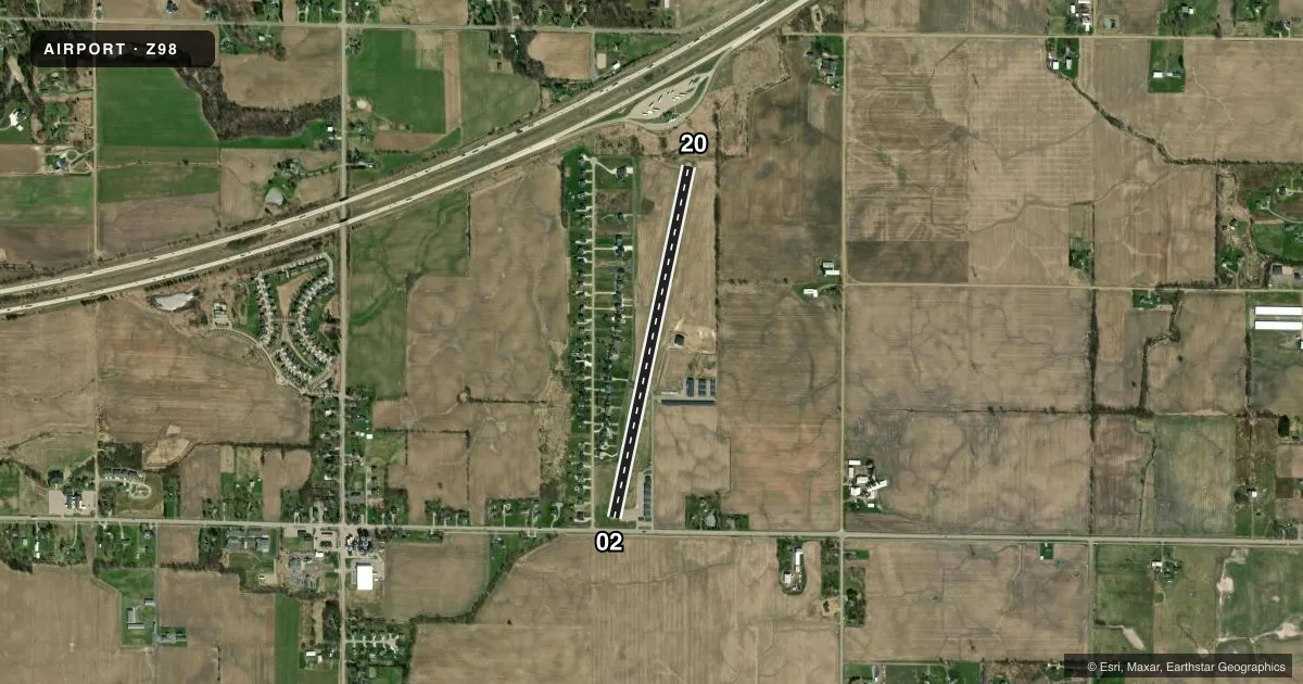
Runways & pattern
Full pagePattern entry · RWY 20
LEFT TRAFFICAirport sketch
Runways drawn to scale from FAA survey coordinates, rendered over satellite imagery. Not for navigation.
Approaches & charts
Services on the field
Fuel grades, oxygen, maintenance, ramp storage and lighting — as declared to the FAA by the airport operator.
Fuel & services
- Fuel
- 100LLA+
- Airframe repair
- Major
- Power plant repair
- Major
- Other services
- INSTR,RNTL
Ramp & ground
- Transient storage
- Tie-down
- Hangar
- Lighting schedule
- SEE RMK
- Wind indicator
- Lighted
- Segmented circle
- Yes
Fuel & FBOs
Cheapest 100LL and Jet A on the field and nearby. Always confirm with the FBO before taxi.
Airport notes
Surface conditions, obstructions, local procedures, lighting outages and other notes published with each FAA cycle.
General notes
- RWY SLPS UP FM SOUTH TO NORTH.
- 200 FT LGTD ANT APRXLY 1900 FT NE OF RWY 20.
- FOR CD CTC GREAT LAKES APCH AT 269-459-3344, WHEN APCH CLSD CTC CHICAGO ARTCC AT 630-906-8921.
- 4 CLICKS ON CTAF FOR WIND, TEMP, & ALTM INFO.
Lighting notes
- ACTVT LIRL RWY 02/20 - CTAF. 5 CLICKS ON SS-SR.
Approach & departure obstructions
- 02+16 FT ROAD, 125 FT DIST, 125 FT L/R; 8 FT SEASONAL CROPS.
- 02APCH RATIO 20:1 TO DTHR.
- 20APCH RATIO 20:1 TO DTHR.
Other notes
- SEE ASP LTR DATED 3/7/94.
VFR map & nearby airports
VFR sectional. Tap any ICAO chip to open that airport.
Key facts · Z98
Answer card- ICAO
- Z98
- Name
- OTTAWA EXEC
- Location
- ZEELAND, MICHIGAN
- Elevation
- 756 ft MSL
- Traffic pattern altitude
- 1,756 ft MSL (1,000 AGL)
- Control tower
- Non-towered (use CTAF)
- Total runways
- 1
- Longest runway
- 02/20 · 3,800 ft
- Published ILS approaches
- 0
- Published frequencies
- 3
- Magnetic variation
- 6°
- Current flight rules
- VFR
- Current wind
- 250° at 9 kt
- Favored runway now
- RWY 20
Ottawa Executive Airport (Z98) sits in Zeeland, Michigan. Field elevation is 756 ft MSL. The airport has one runway. Runway 02/20 is 3,800 ft long with asphalt pavement. There is no control tower. No ILS approaches are published here.
Pattern altitude is not published. Use the standard 1,000 ft AGL for light piston traffic unless the current Chart Supplement says otherwise. The field slopes up from south to north. That matters on rollout and on takeoff from runway 20. There is also a 16-foot road near runway 02. Seasonal crops sit near that end too. A 200-foot lighted antenna lies about 1,900 feet northeast of runway 20.
Ottawa Executive Airport is on the field and carries 100LL and Jet A. Call (616) 772-5970 for current service details. Low intensity runway lights on 02/20 are activated by keying the CTAF five times between sunset and sunrise. Key the CTAF four times for wind, temperature and altimeter information. Great Lakes Approach handles clearance delivery. If approach is closed, contact Chicago ARTCC. First-time pilots should review the current Chart Supplement for any additional remarks before arrival. This is an uncontrolled field with published approach support, so stay sharp on CTAF. Watch the runway slope and nearby obstacles.