METAR & TAF KGRR
Current METAR
Observed 14:53Z
KGRR 271453Z 20006KT 3SM -TSRA BR SCT055CB BKN090 OVC110 22/20 A2986 RMK AO2 TSE27B39 SLP106 OCNL LTGICCG N-SE TS N-SE MOV SE P0007 60014 T02220200 53004 $
- Wind
- 200° @ 6 kt
- Visibility
- 3 SM
- Temp / Dew
- 22°C / 20°C
- Altimeter
- 29.86 inHg
- Clouds
- OVC
- Density alt
- 1,898 ft
- Ceiling
- 9,000 ft AGL
- Rules
- MVFR
Airport info & contacts
Manager on record, flight service, ARTCC, attendance schedule and pattern altitude — published by the FAA and refreshed every 28 days.
Location
- From city
- 6 NM SE
- VFR sectional
- CHICAGO
- ARTCC
- ZAU · CHICAGO
- NOTAM facility
- GRR (NOTAM-D)
Airport manager
- Name
- TORRANCE RICHARDSON
- Phone
- 616-233-6000
- Address
- 5500 44TH ST SE, GRAND RAPIDS MI 49512
Flight service · Hours
- FSS LAN
- LANSING1-800-WX-BRIEF
- Attendance
- ALL
Frequencies
Tap any row to copy the frequency to your clipboard.
Runways & pattern
Full pagePattern entry · RWY 17
LEFT TRAFFIC| Runway | Heading (°M) | Length | Surface | Traffic |
|---|---|---|---|---|
| 08R/26L | 75° / 255° | 10,001 ft | CONC | Standard L |
| 17/35Favored | 165° / 345° | 8,501 ft | CONC | Standard L |
| 08L/26R | 75° / 255° | 5,001 ft | ASPH | Standard L |
Runway end performance
| End | TORA | TODA | ASDA | LDA | VGSI | Approach lights | Obstruction |
|---|---|---|---|---|---|---|---|
| 08R | 10,001' | 10,001' | 10,001' | 10,001' | — | MALSR | — |
| 26L | 10,001' | 10,001' | 10,001' | 10,001' | PAPI 4-box left(3°) | MALSR | 24', bldg, 1170' from thr, 260' R of cntrln, slope 40 |
| 17 | 8,501' | 8,501' | 8,501' | 8,501' | PAPI 4-box right(3°) | — | — |
| 35 | 8,501' | 8,501' | 8,501' | 8,501' | PAPI 4-box right(3°) | MALSR | — |
| 08L | 5,001' | 5,001' | 5,001' | 5,001' | VASI 4-box left(3°) | — | — |
| 26R | 5,001' | 5,001' | 5,001' | 5,001' | VASI 4-box left(3°) | — | — |
Declared distances in feet. TORA = takeoff run available, TODA = takeoff distance, ASDA = accelerate-stop, LDA = landing distance.
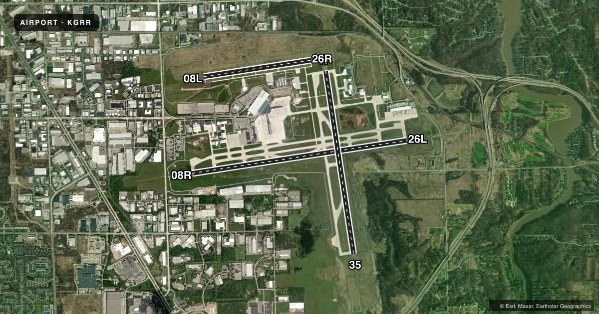
Airport sketch
Runways drawn to scale from FAA survey coordinates, rendered over satellite imagery. Not for navigation.
Approaches & charts
ILS · 3
Services on the field
Fuel grades, oxygen, maintenance, ramp storage and lighting — as declared to the FAA by the airport operator.
Fuel & services
- Fuel
- 100LLA
- Oxygen (bottled)
- High pressure
- Oxygen (bulk)
- High pressure
- Airframe repair
- Major
- Power plant repair
- Major
- Other services
- AFRT,AMB,AVNCS,CARGO,CHTR,INSTR,RNTL,SALES
Ramp & ground
- Transient storage
- Tie-down
- Hangar
- Customs
- Not available
- Lighting schedule
- SEE RMK
- Beacon schedule
- SS-SR
- Beacon
- White / Green (civil land)(WG)
- Wind indicator
- Lighted
- Segmented circle
- No
Fuel & FBOs
Cheapest 100LL and Jet A on the field and nearby. Always confirm with the FBO before taxi.
Airport notes
Surface conditions, obstructions, local procedures, lighting outages and other notes published with each FAA cycle.
General notes
- TWY F NORTH OF TWY V, TWY J BTN TWY F & TWY J3 & TWY G CLSD TO AIRCRAFT OVER 100,000 LBS; TWY F SOUTH OF TWY V & TWY J EAST OF TWY F & WEST OF TWY J3 CLSD TO ACFT OVER 47,000 LBS.
- BIRDS ON & INVOF ARPT.
- NOISE ABATEMENT PROCEDURES: RY 08R DEP ON RY HEADING UNTIL REACHING THE HWY EAST OF ARPT; RY 26L ON APCH TO ARPT TURN FINAL AT HWY EAST OF ARPT.
- PPR FOR ACFT WITH 171 FT WINGSPAN OR LARGER.
- TWY R NORTH OF TWY D, TWY Y NORTH OF TWY D, TWY Z NORTH OF TWY D AND TWY N ARE NON-MOVEMENT AREAS.
- PUSHBACK ADVISORIES ON THE TERMINAL RAMP ARE NOT PRVDD BY ATC.
- ARPT PSNL WILL MNT CTAF WHEN ATCT IS CLSD.
- TWY Y 400 FT NORTH OF TWY D CLSD TO ACFT OVER 100,000 LBS.; TWY R NORTH OF TWY D CLSD TO ACFT OVER 175,000 LBS.
- AIR CARRIER APRON CLOSED TO GA AIRCRAFT.
- CTC FBO FOR THEIR HRS OF OPN.
- FOR CD WHEN TWR CLSD CTC GREAT LAKES APCH AT 269-459-3344, WHEN APCH CLSD CTC CHICAGO ARTCC AT 630-906-8921.
- TWY D HOLD PAD FOR RWY 26L CLSD TO ACFT WITH WINGSPAN GTR THAN 49 FT.
Lighting notes
- WHEN ATCT CLSD ACTVT MALSR RWY 08R, 26L, & 35; REIL RWY 08L, 26R, & 17; HIRL RWY 08R/26L & 17/35; MIRL RWY 08L/26R - CTAF.
Runway surface & condition
- 08L/26RPCR VALUE: 270/F/C/X/T
- 08R/26LPCR VALUE: 470/R/D/W/T
- 17/35PCR VALUE: 660/R/C/W/T
Other notes
- MON-FRI TWO HRS PPR FOR CUSTOMS CALL 616-942-5245, PAGER 616-249-5380. CALL PRIOR TO 1600 ON PRECEDING FRIDAY FOR AFTER HOURS SVC.
VFR map & nearby airports
VFR sectional. Tap any ICAO chip to open that airport.
Key facts · KGRR
Answer card- ICAO
- KGRR
- Name
- GERALD R FORD INTL
- Location
- GRAND RAPIDS, MICHIGAN
- Elevation
- 793.6 ft MSL
- Traffic pattern altitude
- 1,793.6 ft MSL (1,000 AGL)
- Control tower
- Towered · 0530-0000
- Total runways
- 3
- Longest runway
- 08R/26L · 10,001 ft
- Published ILS approaches
- 3
- Published frequencies
- 15
- Magnetic variation
- 6°
- Current flight rules
- MVFR
- Current wind
- 200° at 6 kt
- Favored runway now
- RWY 17
Gerald R Ford Intl is in Grand Rapids, Michigan. Field elevation is 793.6 ft MSL. The airport has three runways. The longest is 10,001 ft on 08R/26L. The tower is open daily from 0530 to 0000. Three ILS approaches are published. They serve runway ends 08R, 26L and 35.
For pattern work, the published pattern altitude is not listed. Use 1,000 ft AGL for light piston operations unless ATC or the current Chart Supplement says otherwise. That puts the light piston pattern at about 1,794 ft MSL based on the field elevation. The airport sits under Class C airspace. Expect busy airline and business traffic. The air carrier apron is closed to general aviation aircraft. Pushback on the terminal ramp is not handled by ATC.
Signature Aviation is on the field. It carries 100LL and Jet A. Avflight Grand Rapids is also on the field. It carries 100LL, Jet A and Jet A Prist. When the tower is closed, airport personnel monitor CTAF. Lighting changes with tower status. Use the CTAF to activate the listed runway lights and approach lighting after hours. Customs requires prior permission on weekdays. Call ahead before you plan an international arrival. Taxiway restrictions also apply to heavier aircraft, so check the current Chart Supplement if you are bringing something large.