METAR & TAF 9D9
9D9 does not publish a METAR.
Showing the nearest reporting station: KGRR (GERALD R FORD INTL) · 15.2 NM away. Conditions at 9D9 may differ.
METAR · KGRR
Observed 11:53Z
KGRR 271153Z 24008KT 2 1/2SM BR BKN007 OVC130 24/23 A2985 RMK AO2 SLP100 T02440233 10244 20206 53002
- Wind
- 240° @ 8 kt
- Visibility
- 0.5 SM
- Temp / Dew
- 24°C / 23°C
- Altimeter
- 29.85 inHg
- Clouds
- OVC
- Density alt
- 2,159 ft
- Ceiling
- 700 ft AGL
- Rules
- LIFR
Airport info & contacts
Manager on record, flight service, ARTCC, attendance schedule and pattern altitude — published by the FAA and refreshed every 28 days.
Location
- From city
- 3 NM W
- VFR sectional
- CHICAGO
- Pattern altitude
- 800 ft AGL · 1,600 ft MSL
- ARTCC
- ZAU · CHICAGO
- NOTAM facility
- LAN (NOTAM-D)
Airport manager
- Name
- GIACINTO LUCCI SR
- Phone
- 269-945-6306
- Address
- 2505 MURPHY DR, HASTINGS MI 49058
Flight service · Hours
- FSS LAN
- LANSING1-800-WX-BRIEF
- Attendance
- IREG
Frequencies
Tap any row to copy the frequency to your clipboard.
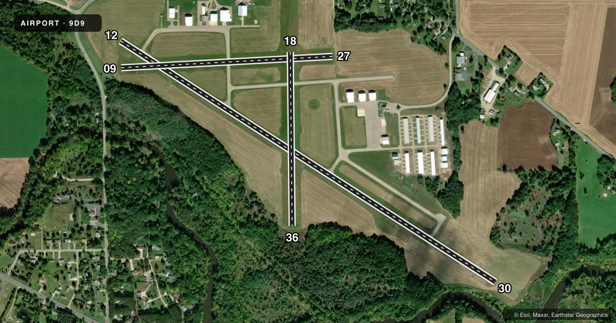
Runways & pattern
Full pagePattern entry · RWY 27
LEFT TRAFFIC| Runway | Heading (°M) | Length | Surface | Traffic |
|---|---|---|---|---|
| 12/30 | 116° / 296° | 5,003 ft | ASPH | Standard L |
| 09/27Favored | 81° / 261° | 2,380 ft | TURF | Standard L |
| 18/36 | 173° / 353° | 1,952 ft | TURF | Standard L |
Runway end performance
| End | TORA | TODA | ASDA | LDA | VGSI | Approach lights | Obstruction |
|---|---|---|---|---|---|---|---|
| 12 | — | — | — | — | PAPI 4-box right(4°) | — | 5', tree, 221' from thr, 250' R of cntrln, slope 4 |
| 30 | — | — | — | — | PAPI 4-box left(3°) | — | 20', tree, 200' from thr, 250' R of cntrln, slope 0 |
| 09 | — | — | — | — | — | — | 13', tree, 79' from thr, 129' R of cntrln, slope 6 |
| 27 | — | — | — | — | — | — | 67', tree, 973' from thr, 245' R of cntrln, slope 14 |
| 18 | — | — | — | — | — | — | 49', tree, 736' from thr, 163' R of cntrln, slope 15 |
| 36 | — | — | — | — | — | — | 8', tree, 38' from thr, 125' R of cntrln, slope 4 |
Declared distances in feet. TORA = takeoff run available, TODA = takeoff distance, ASDA = accelerate-stop, LDA = landing distance.
Airport sketch
Runways drawn to scale from FAA survey coordinates, rendered over satellite imagery. Not for navigation.
Approaches & charts
Services on the field
Fuel grades, oxygen, maintenance, ramp storage and lighting — as declared to the FAA by the airport operator.
Fuel & services
- Fuel
- 100LLA+
- Oxygen (bottled)
- Not available
- Oxygen (bulk)
- Not available
- Airframe repair
- Major
- Power plant repair
- Major
- Other services
- GLD,INSTR
Ramp & ground
- Transient storage
- Tie-down
- Hangar
- Landing fee
- No fee published
- Customs
- Not available
- Lighting schedule
- SEE RMK
- Beacon schedule
- SS-SR
- Beacon
- White / Green (civil land)(WG)
- Wind indicator
- Lighted
- Segmented circle
- Yes
Fuel & FBOs
Cheapest 100LL and Jet A on the field and nearby. Always confirm with the FBO before taxi.
Airport notes
Surface conditions, obstructions, local procedures, lighting outages and other notes published with each FAA cycle.
General notes
- LRG FLOCKS OF LRG BIRDS ON & INVOF ARPT.
- FOR CD CTC GREAT LAKES APCH AT 269-459-3344, WHEN APCH CLSD CTC CHICAGO ARTCC AT 630-906-8921.
Lighting notes
- ACTVT REIL RWY 12 & 30; PAPI RWY 12 & 30; MIRL RWY 12/30 - CTAF.
Approach & departure obstructions
- 09RWY & DTHR MKD WITH 3 FT YELLOW CONES.
- 18RWY MKD WITH 3 FT YELLOW CONES.
- 27RWY & DTHR MKD WITH 3 FT YELLOW CONES.
- 36RWY MKD WITH 3 FT YELLOW CONES.
- 30PAPI UNUSBL BYD 5 DEGS LEFT OF CNTRLN.
- 09APCH RATIO 20:1 TO DTHR.
- 12APCH RATIO 20:1 TO DTHR.
- 27APCH RATIO 20:1 TO DTHR.
Other notes
- MANAGERASST MGR GINO LUCCI JR 517-667-2977
- MANAGERCELL 269-838-5874.
VFR map & nearby airports
VFR sectional. Tap any ICAO chip to open that airport.
Key facts · 9D9
Answer card- ICAO
- 9D9
- Name
- HASTINGS
- Location
- HASTINGS, MICHIGAN
- Elevation
- 800.4 ft MSL
- Traffic pattern altitude
- 1,600.4 ft MSL (800 AGL)
- Control tower
- Non-towered (use CTAF)
- Total runways
- 3
- Longest runway
- 12/30 · 5,003 ft
- Published ILS approaches
- 0
- Published frequencies
- 4
- Magnetic variation
- 6°
- Current flight rules
- LIFR
- Current wind
- 240° at 8 kt
- Favored runway now
- RWY 27
Hastings Airport sits in Hastings, Michigan. Field elevation is 800.4 ft MSL. The airport has three runways. The longest is runway 12/30 at 5,003 ft. There is no control tower, so use CTAF 123.075 for local traffic calls. Pattern altitude is 800 ft AGL, which is 1,600.4 ft MSL.
No ILS approaches are published here. Runway 12/30 has medium intensity runway lights, runway end identifier lights and PAPI. The published remarks also note that runway 30’s PAPI is unusable more than 5 degrees left of centerline. Runway 09 has a displaced threshold. The approach slope to that threshold is 20 to 1. The same 20 to 1 note is published for runways 12, 27 and the displaced threshold on 09.
Hastings Airport is a non-towered field with Great Lakes Approach listed for clearance delivery. Large flocks of birds are reported on and near the airport, so keep your scan moving on departure and arrival. On field, Hastings Airport carries AVGAS_100LL and JET_A. If you need current operating details, call the airport operator or the FBO directly by phone. For airspace and any current procedures, check the current FAA Chart Supplement before you go.