METAR & TAF Y70
Current METAR
Observed 13:15Z
KY70 271315Z AUTO 25014KT 5SM BR FEW008 SCT015 25/23 A2985 RMK AO2 PRESRR
- Wind
- 250° @ 14 kt
- Visibility
- 5 SM
- Temp / Dew
- 25°C / 23°C
- Altimeter
- 29.85 inHg
- Clouds
- SCT
- Density alt
- 2,301 ft
- Ceiling
- Unlimited
- Rules
- MVFR
Airport info & contacts
Manager on record, flight service, ARTCC, attendance schedule and pattern altitude — published by the FAA and refreshed every 28 days.
Location
- From city
- 3 NM S
- VFR sectional
- CHICAGO
- ARTCC
- ZAU · CHICAGO
- NOTAM facility
- Y70 (NOTAM-D)
Airport manager
- Name
- MATT KUHNS
- Phone
- 616-902-2281
- Address
- 468 E SPRAGUE RD, IONIA MI 48846
Flight service · Hours
- FSS LAN
- LANSING1-800-WX-BRIEF
- Attendance
- 0700-1500
Frequencies
Tap any row to copy the frequency to your clipboard.
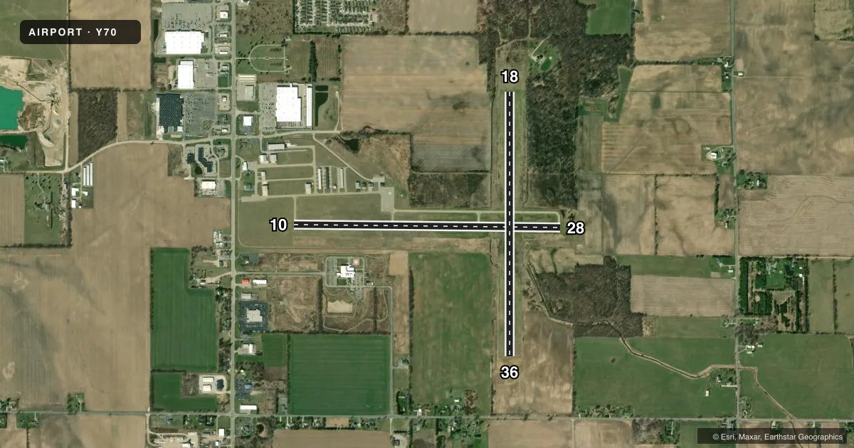
Runways & pattern
Full pagePattern entry · RWY 28
LEFT TRAFFIC| Runway | Heading (°M) | Length | Surface | Traffic |
|---|---|---|---|---|
| 10/28Favored | 86° / 266° | 4,298 ft | ASPH | Standard L |
| 18/36 | 175° / 355° | 4,261 ft | TURF | Standard L |
Runway end performance
| End | TORA | TODA | ASDA | LDA | VGSI | Approach lights | Obstruction |
|---|---|---|---|---|---|---|---|
| 10 | — | — | — | — | PAPI 4-box left(3°) | — | — |
| 28 | — | — | — | — | PAPI 4-box left(3°) | — | — |
| 18 | — | — | — | — | — | — | 82', tree, 1242' from thr, 225' R of cntrln, slope 15 |
| 36 | — | — | — | — | — | — | 73', tree, 986' from thr, 220' R of cntrln, slope 13 |
Declared distances in feet. TORA = takeoff run available, TODA = takeoff distance, ASDA = accelerate-stop, LDA = landing distance.
Airport sketch
Runways drawn to scale from FAA survey coordinates, rendered over satellite imagery. Not for navigation.
Approaches & charts
Services on the field
Fuel grades, oxygen, maintenance, ramp storage and lighting — as declared to the FAA by the airport operator.
Fuel & services
- Fuel
- 100LL
- Oxygen (bottled)
- HIGH/LOW
- Oxygen (bulk)
- Not available
- Airframe repair
- Major
- Power plant repair
- Major
- Other services
- GLD,INSTR,RNTL,TOW
Ramp & ground
- Transient storage
- Tie-down
- Hangar
- Landing fee
- No fee published
- Customs
- Not available
- Lighting schedule
- SEE RMK
- Beacon schedule
- SS-SR
- Beacon
- White / Green (civil land)(WG)
- Wind indicator
- Lighted
- Segmented circle
- Yes
Fuel & FBOs
Cheapest 100LL and Jet A on the field and nearby. Always confirm with the FBO before taxi.
Airport notes
Surface conditions, obstructions, local procedures, lighting outages and other notes published with each FAA cycle.
General notes
- EXTENSIVE SOARING ACTIVITY.
- GLDR OPS CONDUCTED S OF RWY 10/28 & WEST OF RWY 18/36; USE FREQ 123.3 IN PRACTICE AREA. GLDRS USE CTAF IN TFC PAT.
- TREES OBST VIEW BTWN RWY END 18 WITH RWY END 10 & 28.
- HOSPITAL & HOSPITAL HELI ADJ SOUTH OF RWY 10/28.
- FOR CD CTC GREAT LAKES APCH AT 269-459-3345, WHEN APCH CLSD CTC CHICAGO ARTCC AT 630-906-8921.
Lighting notes
- ACTVT REIL RWY 28; PAPI RWY 10 & 28; MIRL RWY 10/28 - CTAF.
Runway surface & condition
- 18/36RWY 18/36 MKD WITH 3 FT YELLOW CONES.
Approach & departure obstructions
- 183 FT YELLOW CONES.
- 10ALSO +25 FT PLINE, 1154 FT DIST, 38:1.
- 36ALSO +33 FT PLINE, 1015 FT DIST, 30:1.
Other notes
- FOR HNGR AVBLTY CALL AMGR.
- 1UNATNDD MAJOR HOLS.
VFR map & nearby airports
VFR sectional. Tap any ICAO chip to open that airport.
Key facts · Y70
Answer card- ICAO
- Y70
- Name
- IONIA COUNTY
- Location
- IONIA, MICHIGAN
- Elevation
- 817.8 ft MSL
- Traffic pattern altitude
- 1,817.8 ft MSL (1,000 AGL)
- Control tower
- Non-towered (use CTAF)
- Total runways
- 2
- Longest runway
- 10/28 · 4,298 ft
- Published ILS approaches
- 0
- Published frequencies
- 4
- Magnetic variation
- 5°
- Current flight rules
- MVFR
- Current wind
- 250° at 14 kt
- Favored runway now
- RWY 28
Ionia County Airport sits in Ionia, Michigan at 817.8 ft MSL. It has two runways. The longest is runway 10/28 at 4,298 ft. The field is unattended on major holidays. There is no control tower. No ILS approaches are published here.
Pattern altitude is not published, so use the standard 1,000 ft AGL for light piston traffic unless local instructions say otherwise. That puts the pattern at about 1,818 ft MSL based on the field elevation. Runway 10/28 is asphalt. Runway 18/36 is turf. Runway 28 has activated runway end identifier lights. Runways 10 and 28 have PAPI. Medium intensity runway lights are on 10/28 and are controlled by CTAF. The on-field FBO is Ionia County Airport. It carries 100LL. Call (616) 523-9136 for current service details.
This is a mixed-use field with extensive soaring activity. Gliders operate south of runway 10/28 and west of runway 18/36. Use 123.3 in the practice area. Gliders use the common traffic advisory frequency in the pattern. Watch for the hospital and helipad south of runway 10/28. Trees affect visibility between the end of runway 18 and the ends of 10 and 28. There is also a power line near runway 10 and another near runway 36. For clearance delivery contact Great Lakes Approach. If approach is closed, contact Chicago ARTCC.