METAR & TAF C63
C63 does not publish a METAR.
Showing the nearest reporting station: KAMN (GRATIOT COMMUNITY) · 16.8 NM away. Conditions at C63 may differ.
METAR · KAMN
Observed 14:55Z
KAMN 271455Z AUTO 25009KT 10SM CLR 27/21 A2979 RMK AO2
- Wind
- 250° @ 9 kt
- Visibility
- 10 SM
- Temp / Dew
- 27°C / 21°C
- Altimeter
- 29.79 inHg
- Clouds
- CLR
- Density alt
- 2,641 ft
- Ceiling
- Unlimited
- Rules
- VFR
Airport info & contacts
Manager on record, flight service, ARTCC, attendance schedule and pattern altitude — published by the FAA and refreshed every 28 days.
Location
- From city
- 3 NM SSE
- VFR sectional
- CHICAGO
- ARTCC
- ZAU · CHICAGO
- NOTAM facility
- LAN (NOTAM-D)
Airport manager
- Name
- DAVE HARRISON
- Phone
- 616-894-0255
- Address
- 363 POTTER PL, STANTON MI 48888-8938
Flight service · Hours
- FSS LAN
- LANSING1-800-WX-BRIEF
- Attendance
- Unattended
Frequencies
Tap any row to copy the frequency to your clipboard.
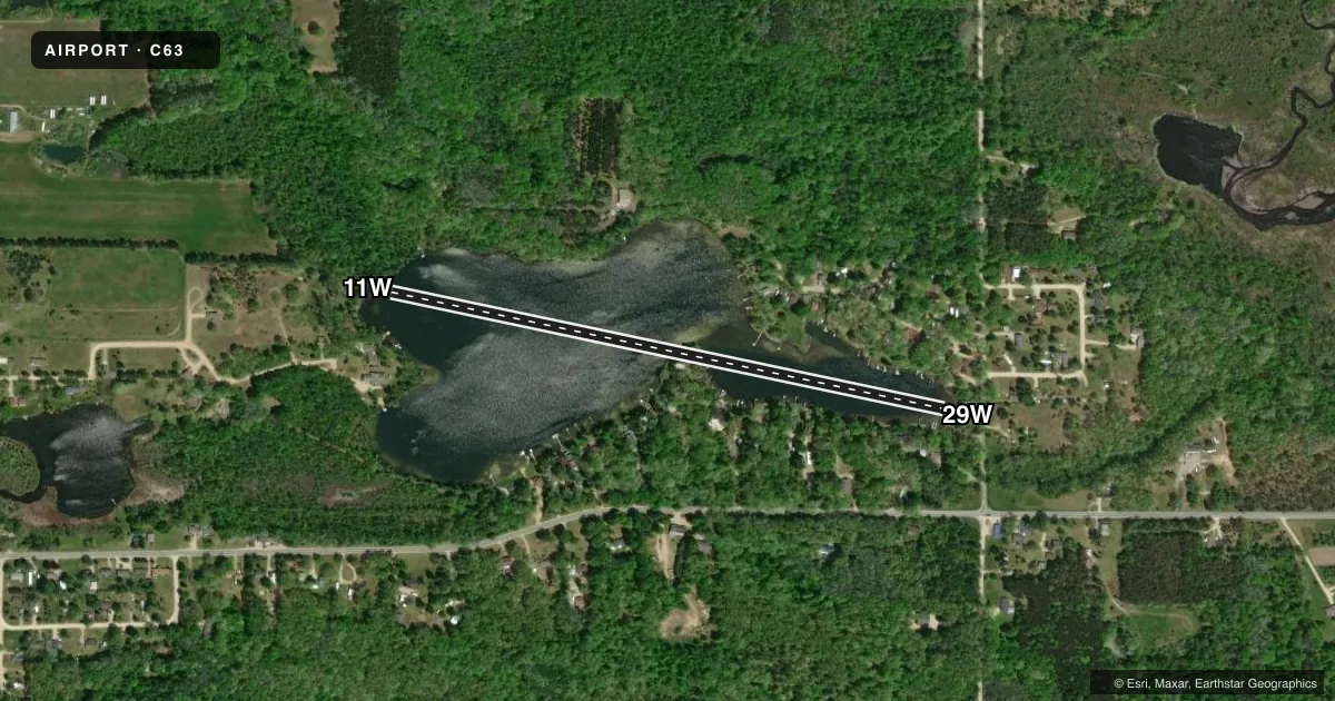
Runways & pattern
Full pagePattern entry · RWY 29W
LEFT TRAFFICAirport sketch
Runways drawn to scale from FAA survey coordinates, rendered over satellite imagery. Not for navigation.
Approaches & charts
Services on the field
Fuel grades, oxygen, maintenance, ramp storage and lighting — as declared to the FAA by the airport operator.
Fuel & services
- Fuel
- Not available
Ramp & ground
- Transient storage
- Not published
Fuel & FBOs
Cheapest 100LL and Jet A on the field and nearby. Always confirm with the FBO before taxi.
Airport notes
Surface conditions, obstructions, local procedures, lighting outages and other notes published with each FAA cycle.
General notes
- FOR CD CTC GREAT LAKES APCH AT 269-459-3344, WHEN APCH CLSD CTC CHICAGO ARTCC AT 630-906-8921.
VFR map & nearby airports
VFR sectional. Tap any ICAO chip to open that airport.
Key facts · C63
Answer card- ICAO
- C63
- Name
- RAYRAY
- Location
- STANTON, MICHIGAN
- Elevation
- 838.7 ft MSL
- Traffic pattern altitude
- 1,838.7 ft MSL (1,000 AGL)
- Control tower
- Non-towered (use CTAF)
- Total runways
- 1
- Longest runway
- 11W/29W · 2,900 ft
- Published ILS approaches
- 0
- Published frequencies
- 1
- Magnetic variation
- –
- Current flight rules
- VFR
- Current wind
- 250° at 9 kt
- Favored runway now
- RWY 29W
RAYRAY sits in Stanton, Michigan. The field elevation is 838.7 ft MSL. It has one runway. The longest is 11W/29W at 2,900 ft on water. There is no control tower. CTAF is 122.9.
No ILS approaches are published here. Pattern altitude is not published in the facts block, so verify the current Chart Supplement before you fly. For clearance delivery, contact Great Lakes Approach at 269-459-3344. When Approach is closed, contact Chicago ARTCC at 630-906-8921.
There are no on-field FBOs listed in the facts. Contact the airport operator directly before arrival, or call the field on CTAF for current FBO availability. For a first visit, plan around the water runway setup and confirm current local procedures before departure. The field is in Stanton, so check the current Chart Supplement for any published local restrictions or operational notes before you go.