METAR & TAF KAMN
Current METAR
Observed 17:15Z
KAMN 271715Z AUTO 27009KT 10SM CLR 29/19 A2973 RMK AO2 PRESFR
- Wind
- 270° @ 9 kt
- Visibility
- 10 SM
- Temp / Dew
- 29°C / 19°C
- Altimeter
- 29.73 inHg
- Clouds
- CLR
- Density alt
- 2,851 ft
- Ceiling
- Unlimited
- Rules
- VFR
Airport info & contacts
Manager on record, flight service, ARTCC, attendance schedule and pattern altitude — published by the FAA and refreshed every 28 days.
Location
- From city
- 3 NM SW
- VFR sectional
- DETROIT
- ARTCC
- ZOB · CLEVELAND
- NOTAM facility
- AMN (NOTAM-D)
Airport manager
- Name
- SCOTT MCDONALD
- Phone
- 989-463-5500
- Address
- 3999 W SEAMAN RD, ALMA MI 48801-9232
Flight service · Hours
- FSS LAN
- LANSING1-800-WX-BRIEF
- Attendance
- MON-SAT · 0830-1430
Frequencies
Tap any row to copy the frequency to your clipboard.
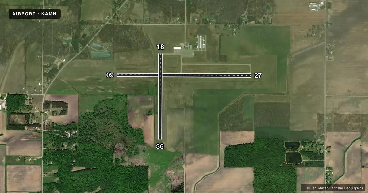
Runways & pattern
Full pagePattern entry · RWY 27
LEFT TRAFFIC| Runway | Heading (°M) | Length | Surface | Traffic |
|---|---|---|---|---|
| 09/27Favored | 85° / 265° | 5,004 ft | ASPH | Standard L |
| 18/36 | 175° / 355° | 3,198 ft | ASPH | Standard L |
Runway end performance
| End | TORA | TODA | ASDA | LDA | VGSI | Approach lights | Obstruction |
|---|---|---|---|---|---|---|---|
| 09 | — | — | — | — | PAPI 4-box left(3°) | — | 79', tree, 2307' from thr, 266' R of cntrln, slope 26 |
| 27 | — | — | — | — | PAPI 4-box left(3°) | — | — |
| 18 | — | — | — | — | — | — | 56', tree, 1119' from thr, 383' R of cntrln, slope 16 |
Declared distances in feet. TORA = takeoff run available, TODA = takeoff distance, ASDA = accelerate-stop, LDA = landing distance.
Airport sketch
Runways drawn to scale from FAA survey coordinates, rendered over satellite imagery. Not for navigation.
Approaches & charts
Services on the field
Fuel grades, oxygen, maintenance, ramp storage and lighting — as declared to the FAA by the airport operator.
Fuel & services
- Fuel
- 100LLA+
- Oxygen (bottled)
- Not available
- Oxygen (bulk)
- Not available
- Airframe repair
- Not available
- Power plant repair
- Not available
- Other services
- INSTR,RNTL
Ramp & ground
- Transient storage
- Tie-down
- Hangar
- Landing fee
- No fee published
- Customs
- Not available
- Lighting schedule
- SEE RMK
- Beacon schedule
- SS-SR
- Beacon
- White / Green (civil land)(WG)
- Wind indicator
- Lighted
- Segmented circle
- Yes
Fuel & FBOs
Cheapest 100LL and Jet A on the field and nearby. Always confirm with the FBO before taxi.
Airport notes
Surface conditions, obstructions, local procedures, lighting outages and other notes published with each FAA cycle.
General notes
- DEER & LRG BIRDS ON & INVOF ARPT.
- ADMIN BLDG ACES, PRESS V, THEN III & II SIMUL, THEN I.
- FOR CD CTC GREAT LAKES APCH AT 269-459-3345, WHEN APCH CLSD CTC CLEVELAND ARTCC AT 440-774-0224/0490.
Lighting notes
- ACTVT REIL RWY 09 & 27; PAPI RWY 09 & 27; MIRL RWY 09/27 & 18/36 - CTAF.
Other notes
- CALL AHD FOR HNGR AVBL.
VFR map & nearby airports
VFR sectional. Tap any ICAO chip to open that airport.
Key facts · KAMN
Answer card- ICAO
- KAMN
- Name
- GRATIOT COMMUNITY
- Location
- ALMA, MICHIGAN
- Elevation
- 754.1 ft MSL
- Traffic pattern altitude
- 1,754.1 ft MSL (1,000 AGL)
- Control tower
- Non-towered (use CTAF)
- Total runways
- 2
- Longest runway
- 09/27 · 5,004 ft
- Published ILS approaches
- 0
- Published frequencies
- 4
- Magnetic variation
- 5°
- Current flight rules
- VFR
- Current wind
- 270° at 9 kt
- Favored runway now
- RWY 27
Gratiot Community Airport sits in Alma, Michigan. Field elevation is 754.1 ft MSL. It has two asphalt runways. The longest is 5,004 ft on 09/27. The other runway is 18/36 at 3,198 ft. There is no control tower. Pattern altitude is not published, so use the standard 1,000 ft AGL for light piston traffic unless the current Chart Supplement says otherwise.
No ILS approaches are published here. That matters if you are planning an IFR arrival in marginal weather. Check the current Chart Supplement for the latest approach setup before you go. The field has CTAF and UNICOM on 122.8. Great Lakes Approach uses 126.45 and 235.625 for approach and departure services. For clearance delivery, the published remarks direct you to Great Lakes Approach or Cleveland ARTCC when Approach is closed.
Three Point Aviation is on the field. It carries 100LL and Jet A with Prist. Call ahead at (989) 463-5500. Published remarks also say to call ahead for hangar availability. Expect wildlife on and near the airport. Runway end identifier lights are on 09 and 27. PAPI is also on 09 and 27. Medium intensity runway lights are on both runways and are controlled by CTAF. The admin building access note is unusual, so verify it before you plan to use the building after arrival.