METAR & TAF KMOP
Current METAR
Observed 18:55Z
KMOP 271855Z AUTO 20010KT 10SM -RA SCT047 SCT060 BKN095 24/20 A2974 RMK AO2 T02400196
- Wind
- 200° @ 10 kt
- Visibility
- 10 SM
- Temp / Dew
- 24°C / 20°C
- Altimeter
- 29.74 inHg
- Clouds
- BKN
- Density alt
- 2,239 ft
- Ceiling
- 9,500 ft AGL
- Rules
- VFR
Airport info & contacts
Manager on record, flight service, ARTCC, attendance schedule and pattern altitude — published by the FAA and refreshed every 28 days.
Location
- From city
- 2 NM NE
- VFR sectional
- DETROIT
- ARTCC
- ZOB · CLEVELAND
- NOTAM facility
- MOP (NOTAM-D)
Airport manager
- Name
- BILL BRICKNER
- Phone
- 989-772-2965
- Address
- 5453 E AIRPORT RD, MOUNT PLEASANT MI 48858-8923
Flight service · Hours
- FSS LAN
- LANSING1-800-WX-BRIEF
- Attendance
- MON-FRI · 0800-1630
Frequencies
Tap any row to copy the frequency to your clipboard.
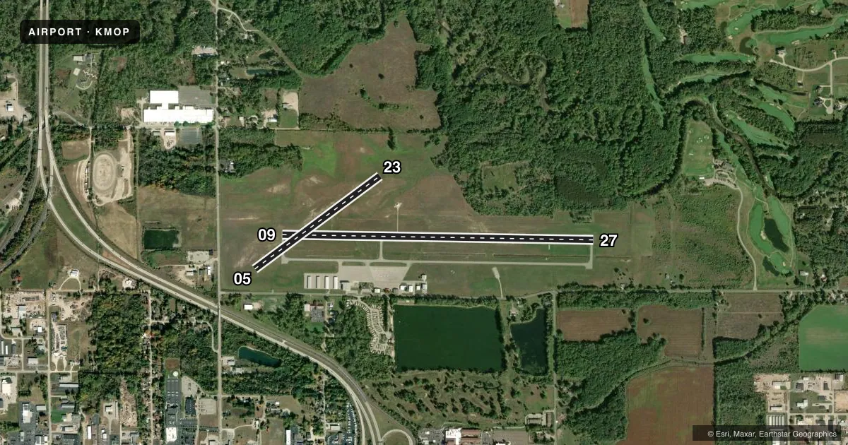
Runways & pattern
Full pagePattern entry · RWY 23
LEFT TRAFFIC| Runway | Heading (°M) | Length | Surface | Traffic |
|---|---|---|---|---|
| 09/27 | 86° / 266° | 5,000 ft | ASPH | Standard L |
| 05/23Favored | 48° / 228° | 2,502 ft | TURF | Standard L |
Runway end performance
| End | TORA | TODA | ASDA | LDA | VGSI | Approach lights | Obstruction |
|---|---|---|---|---|---|---|---|
| 09 | — | — | — | — | PAPI 4-box left(3°) | — | 31', pole, 1074' from thr, 338' R of cntrln, slope 28 |
| 27 | — | — | — | — | PAPI 4-box left(3°) | — | — |
| 05 | — | — | — | — | — | — | 39', tree, 577' from thr, 196' R of cntrln, slope 14 |
| 23 | — | — | — | — | — | — | 44', tree, 453' from thr, 189' R of cntrln, slope 10 |
Declared distances in feet. TORA = takeoff run available, TODA = takeoff distance, ASDA = accelerate-stop, LDA = landing distance.
Airport sketch
Runways drawn to scale from FAA survey coordinates, rendered over satellite imagery. Not for navigation.
Approaches & charts
Services on the field
Fuel grades, oxygen, maintenance, ramp storage and lighting — as declared to the FAA by the airport operator.
Fuel & services
- Fuel
- 100LLA+
- Oxygen (bottled)
- Not available
- Oxygen (bulk)
- Not available
Ramp & ground
- Transient storage
- Tie-down
- Hangar
- Landing fee
- No fee published
- Customs
- Not available
- Lighting schedule
- SEE RMK
- Beacon schedule
- SS-SR
- Beacon
- White / Green (civil land)(WG)
- Wind indicator
- Lighted
- Segmented circle
- No
Fuel & FBOs
Cheapest 100LL and Jet A on the field and nearby. Always confirm with the FBO before taxi.
Airport notes
Surface conditions, obstructions, local procedures, lighting outages and other notes published with each FAA cycle.
General notes
- DEER & LRG BIRDS ON & INVOF ARPT.
- RWY 27 NOISE ABATEMENT: CLIMB TO 1500 FT AGL BFR TURNING OVR CITY.
- ADMIN BLDG ACES: PRESS V, THEN III & II SIMUL, THEN I. GATE ACES: 1-2-3-4.
- FOR CD CTC GREAT LAKES APCH AT 269-459-3345, WHEN APCH CLSD CTC CLEVELAND ARTCC AT 440-774-0224/0490.
Lighting notes
- ACTVT REIL RWY 09 & 27; PAPI RWY 27; MIRL RWY 09/27 - CTAF. PAPI RWY 09 OPR CONSLY.
Fuel notes
- 100LLFUEL AVBL H24 SELF SVC VIA CREDIT CARD. FOR SVC AFT HRS CALL 989-779-5475 SUBJ CALL-IN FEE. RAMP FEE FOR ALL COML ACFT - WAIVED WITH 50 GALLON MNM FUEL PURCHASE.
Runway surface & condition
- 05/23CLSD NOV-MAR & WHEN SNOW COVD - NO SNOW REMOVAL.
Approach & departure obstructions
- 053 FT YELLOW CONES.
- 233 FT YELLOW CONES.
Other notes
- MANAGERCELL 989-444-1996.
VFR map & nearby airports
VFR sectional. Tap any ICAO chip to open that airport.
Key facts · KMOP
Answer card- ICAO
- KMOP
- Name
- MOUNT PLEASANT MUNI
- Location
- MOUNT PLEASANT, MICHIGAN
- Elevation
- 754.7 ft MSL
- Traffic pattern altitude
- 1,754.7 ft MSL (1,000 AGL)
- Control tower
- Non-towered (use CTAF)
- Total runways
- 2
- Longest runway
- 09/27 · 5,000 ft
- Published ILS approaches
- 0
- Published frequencies
- 4
- Magnetic variation
- 5°
- Current flight rules
- VFR
- Current wind
- 200° at 10 kt
- Favored runway now
- RWY 23
Mount Pleasant Muni sits in Mount Pleasant, Michigan. Field elevation is 754.7 ft MSL. The airport has two runways. The longest is 09/27 at 5,000 ft asphalt. Runway 05/23 is 2,502 ft turf. There is no control tower. Pattern altitude is not published, so use the standard 1,000 ft AGL for light piston traffic unless current local guidance says otherwise.
No ILS approaches are published here. CTAF and UNICOM are both 123.0. Great Lakes Approach uses 126.45 and 235.625 for approach and departure services. For clearance delivery, the published remark points pilots to Great Lakes Approach by phone. When approach is closed, contact Cleveland ARTCC.
Mt. Pleasant Airport is the on-field FBO. It carries 100LL and Jet A Prist. 100LL is available 24 hours a day through self-service credit card. The published remarks also note deer and large birds on and near the airport. Runway 27 has a noise abatement procedure. Climb to 1,500 ft AGL before turning over the city. Runway 05/23 is closed from November through March and when snow covered. There is no snow removal, so plan around that if you are looking at the turf strip.