METAR & TAF D15
D15 does not publish a METAR.
Showing the nearest reporting station: KMOP (MOUNT PLEASANT MUNI) · 10.7 NM away. Conditions at D15 may differ.
METAR · KMOP
Observed 19:15Z
KMOP 271915Z AUTO 23011G15KT 10SM -RA SCT044 SCT060 BKN075 24/21 A2973 RMK AO2 T02350205
- Wind
- 230° @ 11G15 kt
- Visibility
- 10 SM
- Temp / Dew
- 24°C / 21°C
- Altimeter
- 29.73 inHg
- Clouds
- BKN
- Density alt
- 2,414 ft
- Ceiling
- 7,500 ft AGL
- Rules
- VFR
Airport info & contacts
Manager on record, flight service, ARTCC, attendance schedule and pattern altitude — published by the FAA and refreshed every 28 days.
Location
- From city
- 1 NM E
- VFR sectional
- DETROIT
- ARTCC
- ZMP · MINNEAPOLIS
- NOTAM facility
- LAN (NOTAM-D)
Airport manager
- Name
- TOM COURSER
- Phone
- 989-644-2504
- Address
- 1010 CLUBHOUSE DR, LAKE ISABELLA MI 48893-9339
Flight service · Hours
- FSS LAN
- LANSING1-800-WX-BRIEF
- Attendance
- Unattended
Frequencies
Tap any row to copy the frequency to your clipboard.
Runways & pattern
Full pagePattern entry · RWY 29
LEFT TRAFFICRunway end performance
| End | TORA | TODA | ASDA | LDA | VGSI | Approach lights | Obstruction |
|---|---|---|---|---|---|---|---|
| 11 | — | — | — | — | — | — | 74', tree, 267' from thr, 85' R of cntrln, slope 0 |
| 29 | — | — | — | — | — | — | 32', trees, 201' from thr, 0' R of cntrln, slope 0 |
Declared distances in feet. TORA = takeoff run available, TODA = takeoff distance, ASDA = accelerate-stop, LDA = landing distance.
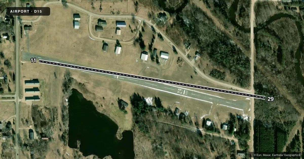
Airport sketch
Runways drawn to scale from FAA survey coordinates, rendered over satellite imagery. Not for navigation.
Approaches & charts
Services on the field
Fuel grades, oxygen, maintenance, ramp storage and lighting — as declared to the FAA by the airport operator.
Fuel & services
- Fuel
- Not available
Ramp & ground
- Transient storage
- Not published
- Landing fee
- No fee published
- Lighting schedule
- SS-SR
- Wind indicator
- Yes
- Segmented circle
- No
Fuel & FBOs
Cheapest 100LL and Jet A on the field and nearby. Always confirm with the FBO before taxi.
Airport notes
Surface conditions, obstructions, local procedures, lighting outages and other notes published with each FAA cycle.
General notes
- SNOW REMOVAL IREG - FOR ARPT CONDS CALL OWNER OR AMGR.
- FOR CD CTC MINNEAPOLIS ARTCC AT 651-463-5588.
Runway surface & condition
- 11/29NSTD LIRL DUE TO NON FAA APVD FIXTURES; LCTD 53 FT NORTH & 34 FT SOUTH OF RWY EDGE.
Approach & departure obstructions
- 1117 FT ROAD, 41-90 FT DIST; 20 FT BLDG, 144 FT DIST, 105 FT R; 20 FT BLDG, 177 FT DIST, 120 FT L; 50 FT TREE, 199 FT DIST, 100 FT R.
- 2915 FT ROAD, 36-83 FT DIST; 15 FT BRUSH, 40 FT DIST.
- 11APCH RATIO 20:1 TO DTHR.
- 29APCH RATIO 20:1 TO DTHR OVR 44 FT TREES, 800 FT DIST, 155 FT R; 10:1 OVR 66 FT TREES, 663 FT DIST, 175 FT L, 20:1 BASED ON STRAIGHT OUT.
Other notes
- MANAGERCELL 989-621-3628.
VFR map & nearby airports
VFR sectional. Tap any ICAO chip to open that airport.
Key facts · D15
Answer card- ICAO
- D15
- Name
- LAKE ISABELLA/CAL BREWER MEML
- Location
- LAKE ISABELLA, MICHIGAN
- Elevation
- 886 ft MSL
- Traffic pattern altitude
- 1,886 ft MSL (1,000 AGL)
- Control tower
- Non-towered (use CTAF)
- Total runways
- 1
- Longest runway
- 11/29 · 2,582 ft
- Published ILS approaches
- 0
- Published frequencies
- 2
- Magnetic variation
- 5°
- Current flight rules
- VFR
- Current wind
- 230° at 11 kt
- Favored runway now
- RWY 29
Lake Isabella/Cal Brewer Meml Airport (D15) sits in Lake Isabella, Michigan. Field elevation is 886 ft MSL. The airport has one runway. Runway 11/29 is 2,582 ft long and asphalt. There is no control tower. CTAF and UNICOM are both 122.8. No ILS approaches are published here.
Pattern altitude is not published. Use the standard 1,000 ft AGL pattern unless the current Chart Supplement or airport operator gives you a different instruction. That puts the light piston pattern at about 1,886 ft MSL based on the field elevation. The published remarks matter here. Snow removal is irregular, so winter access can change fast. The runway 11 and runway 29 approaches also have nearby trees, roads and buildings called out in the Chart Supplement. Expect to review those before you go.
There are no on-field FBOs listed. If you need fuel or other services, contact the airport operator directly before arrival. For clearance delivery, Minneapolis ARTCC is listed in the remarks. The manager cell number is also published in the Chart Supplement. This is a small non-towered field with limited published approach support. Plan the arrival carefully. Verify current runway condition before departure.