METAR & TAF 27C
27C does not publish a METAR.
Showing the nearest reporting station: KRQB (ROBEN-HOOD) · 12.0 NM away. Conditions at 27C may differ.
METAR · KRQB
Observed 16:55Z
KRQB 271655Z AUTO 05006KT 10SM FEW085 25/19 A2974 RMK AO2 PRESFR
- Wind
- 050° @ 6 kt
- Visibility
- 10 SM
- Temp / Dew
- 25°C / 19°C
- Altimeter
- 29.74 inHg
- Clouds
- FEW
- Density alt
- 2,690 ft
- Ceiling
- Unlimited
- Rules
- VFR
Airport info & contacts
Manager on record, flight service, ARTCC, attendance schedule and pattern altitude — published by the FAA and refreshed every 28 days.
Location
- From city
- 2 NM W
- VFR sectional
- CHICAGO
- ARTCC
- ZMP · MINNEAPOLIS
- NOTAM facility
- LAN (NOTAM-D)
Airport manager
- Name
- TREVER WALBURG
- Phone
- 231-972-8880
- Address
- 10964 90TH AVE, MECOSTA MI 49332-9739
Flight service · Hours
- FSS LAN
- LANSING1-800-WX-BRIEF
- Attendance
- Unattended
Frequencies
Tap any row to copy the frequency to your clipboard.
Runways & pattern
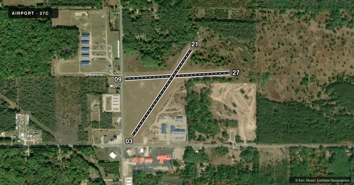
Full pagePattern entry · RWY 03
LEFT TRAFFIC| Runway | Heading (°M) | Length | Surface | Traffic |
|---|---|---|---|---|
| 09/27 | 87° / 267° | 2,027 ft | TURF | Standard L |
| 03/21Favored | 34° / 214° | 2,010 ft | TURF | Standard L |
Runway end performance
| End | TORA | TODA | ASDA | LDA | VGSI | Approach lights | Obstruction |
|---|---|---|---|---|---|---|---|
| 09 | — | — | — | — | — | — | 15', road, 38' from thr, 0' R of cntrln, slope 2 |
| 27 | — | — | — | — | — | — | 8', tree, 0' from thr, 110' R of cntrln, slope 0 |
| 03 | — | — | — | — | — | — | 17', road, 100' from thr, 135' R of cntrln, slope 5 |
| 21 | — | — | — | — | — | — | 30', trees, 0' from thr, 115' R of cntrln, slope 0 |
Declared distances in feet. TORA = takeoff run available, TODA = takeoff distance, ASDA = accelerate-stop, LDA = landing distance.
Airport sketch
Runways drawn to scale from FAA survey coordinates, rendered over satellite imagery. Not for navigation.
Approaches & charts
Services on the field
Fuel grades, oxygen, maintenance, ramp storage and lighting — as declared to the FAA by the airport operator.
Fuel & services
- Fuel
- Not available
- Oxygen (bottled)
- Not available
- Oxygen (bulk)
- Not available
- Airframe repair
- Not available
- Power plant repair
- Not available
Ramp & ground
- Transient storage
- Not published
- Landing fee
- No fee published
- Customs
- Not available
- Wind indicator
- Yes
- Segmented circle
- Yes
Fuel & FBOs
Cheapest 100LL and Jet A on the field and nearby. Always confirm with the FBO before taxi.
Airport notes
Surface conditions, obstructions, local procedures, lighting outages and other notes published with each FAA cycle.
General notes
- NO SNOW REMOVAL.
- UAS OPR ON RWY 09/27 E OF RWY 03/21 INT.
- FOR CD CTC MINNEAPOLIS ARTCC AT 651-463-5588.
Approach & departure obstructions
- 03RWY & DTHR MKD WITH 18 IN YELLOW CONES.
- 09RWY & DTHR MKD WITH 18 IN YELLOW CONES.
- 21RWY & DTHR MKD WITH 18 IN YELLOW CONES.
- 27RWY MKD WITH 18 IN YELLOW CONES.
- 03APCH RATIO 20:1 AT DTHR OVR 91 FT TREES, 1820 FT DIST, 0 FT B.
- 09APCH RATIO 13:1 AT DTHR OVR 62 FT TREE, 860 FT DIST, 130 FT R; 20:1 BASED ON STRAIGHT OUT.
- 21APCH RATIO 5:1 AT DTHR OVR 54 FT TREE, 273 FT DIST, 125 FT L; 17:1 BASED ON STRAIGHT OUT OVR 58 FT TREE, 1034 FT DIST, 45 FT R.
- 27APCH RATIO 20:1 BASED ON STRAIGHT OUT OVR 38 FT TREES, 773 FT DIST, 0 FT B.
Other notes
- PRVDD VFR WX CONDS; RWY 03 THR DSPLCD TO PRVD 20:1 TO CLR TV TWR & PLINE SW OF ARPT; RWY 09 THR DSPLCD TO PRVD 20:1 TO CLR ROAD W OF ARPT; TREES NEAR RWY 03/21 INT BE CLRD; TREES S OF THE E END OF RWY 09/27 BE CLRD TO PRVD A 7:1 BGNG FM THE S EDGE OF PRI SFC.
VFR map & nearby airports
VFR sectional. Tap any ICAO chip to open that airport.
Key facts · 27C
Answer card- ICAO
- 27C
- Name
- MECOSTA MORTON
- Location
- MECOSTA, MICHIGAN
- Elevation
- 1,022 ft MSL
- Traffic pattern altitude
- 2,022 ft MSL (1,000 AGL)
- Control tower
- Non-towered (use CTAF)
- Total runways
- 2
- Longest runway
- 09/27 · 2,027 ft
- Published ILS approaches
- 0
- Published frequencies
- 1
- Magnetic variation
- –
- Current flight rules
- VFR
- Current wind
- 050° at 6 kt
- Favored runway now
- RWY 03
Mecosta Morton (27C) sits in Mecosta, Michigan. Field elevation is 1,022 ft MSL. The airport has two turf runways. The longest is 09/27 at 2,027 ft. There is no control tower. CTAF is 122.9. No ILS approaches are published here.
Pattern altitude is not published. Use the standard 1,000 ft AGL for light piston traffic unless the current FAA Chart Supplement says otherwise. That puts the pattern about 2,022 ft MSL based on the listed field elevation. The field has no on-field FBOs listed, so plan to self-brief and verify services before you go.
The published remarks matter here. Runway 03 has a displaced threshold to help clear a TV tower and power line southwest of the airport. Runway 09 also has a displaced threshold for road clearance. Trees near the 03/21 intersection are scheduled to be cleared. Trees south of the east end of 09/27 are also part of the published obstacle picture. Yellow cones mark the runway and displaced threshold areas on 03, 09, 21 and 27. There is no snow removal. Clearance delivery is handled through Minneapolis ARTCC at 651-463-5588. This is a turf field with short runways. Check performance, surface condition and obstacle clearance before you launch or land.