METAR & TAF 53W
53W does not publish a METAR.
Showing the nearest reporting station: KMOP (MOUNT PLEASANT MUNI) · 11.3 NM away. Conditions at 53W may differ.
METAR · KMOP
Observed 17:15Z
KMOP 271715Z AUTO 27009KT 10SM CLR 29/18 A2975 RMK AO2 T02920182
- Wind
- 270° @ 9 kt
- Visibility
- 10 SM
- Temp / Dew
- 29°C / 18°C
- Altimeter
- 29.75 inHg
- Clouds
- CLR
- Density alt
- 3,054 ft
- Ceiling
- Unlimited
- Rules
- VFR
Airport info & contacts
Manager on record, flight service, ARTCC, attendance schedule and pattern altitude — published by the FAA and refreshed every 28 days.
Location
- From city
- 4 NM NW
- VFR sectional
- DETROIT
- ARTCC
- ZAU · CHICAGO
- NOTAM facility
- LAN (NOTAM-D)
Airport manager
- Name
- WALTER BALLAUER
- Phone
- 989-309-3030
- Address
- 6438 W MILLBROOK RD, REMUS MI 49340-9625
Flight service · Hours
- FSS LAN
- LANSING1-800-WX-BRIEF
- Attendance
- IREG
Frequencies
Tap any row to copy the frequency to your clipboard.
Runways & pattern
Full pagePattern entry · RWY 27
LEFT TRAFFICRunway end performance
| End | TORA | TODA | ASDA | LDA | VGSI | Approach lights | Obstruction |
|---|---|---|---|---|---|---|---|
| 09 | — | — | — | — | — | — | 10', road, 0' from thr, 95' R of cntrln, slope 0 |
| 27 | — | — | — | — | — | — | 15', road, 0' from thr, 110' R of cntrln, slope 0 |
Declared distances in feet. TORA = takeoff run available, TODA = takeoff distance, ASDA = accelerate-stop, LDA = landing distance.
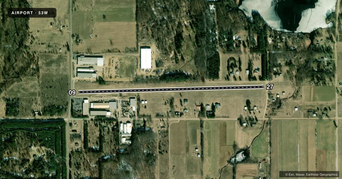
Airport sketch
Runways drawn to scale from FAA survey coordinates, rendered over satellite imagery. Not for navigation.
Approaches & charts
Services on the field
Fuel grades, oxygen, maintenance, ramp storage and lighting — as declared to the FAA by the airport operator.
Fuel & services
- Fuel
- Not available
Ramp & ground
- Transient storage
- Not published
- Wind indicator
- Yes
- Segmented circle
- No
Fuel & FBOs
Cheapest 100LL and Jet A on the field and nearby. Always confirm with the FBO before taxi.
Airport notes
Surface conditions, obstructions, local procedures, lighting outages and other notes published with each FAA cycle.
General notes
- UAS OPR SOUTH OF RWY.
- FOR CD CTC GREAT LAKES APCH AT 269-459-3344, WHEN APCH CLSD CTC CHICAGO ARTCC AT 630-906-8921.
Runway surface & condition
- 09/27CLSD WHEN SNOW COVD - CK NOTAMS.
Approach & departure obstructions
- 09RWY & DTHR MKD WITH 3 FT YELLOW CONES.
- 27RWY & DTHR MKD WITH 3 FT YELLOW CONES.
- 09APCH RATIO 7:1 TO DTHR OVR 50 FT TREE, 350 FT DIST, 125 FT R.
- 27APCH RATIO 0:1 TO DTHR OVR 55 FT TREE, 0 FT DIST, 120 FT R.
- 09ALSO 17 FT ROAD, 134 FT DIST, 138 FT L/R; 10 FT ROAD, 80 FT DIST, 133 FT L/R.
Other notes
- PRVDD OBSTNS IN RWY APCH SFCS BE LWRD/REMOVED OR THRS DSPLCD & MKD TO PRVD MNM 20:1 APCH CLNC OVR ALL OBSTNS.
- MANAGERCELL 989-400-9545.
VFR map & nearby airports
VFR sectional. Tap any ICAO chip to open that airport.
Key facts · 53W
Answer card- ICAO
- 53W
- Name
- WOODRUFF LAKE
- Location
- WINN, MICHIGAN
- Elevation
- 938 ft MSL
- Traffic pattern altitude
- 1,938 ft MSL (1,000 AGL)
- Control tower
- Non-towered (use CTAF)
- Total runways
- 1
- Longest runway
- 09/27 · 3,700 ft
- Published ILS approaches
- 0
- Published frequencies
- 1
- Magnetic variation
- 4°
- Current flight rules
- VFR
- Current wind
- 270° at 9 kt
- Favored runway now
- RWY 27
Woodruff Lake Airport sits in Winn, Michigan. The field elevation is 938 ft MSL. It has one runway, 09/27 and the longest runway is 3,700 ft of turf. There is no control tower. CTAF is 122.9.
No ILS approaches are published here. The pattern altitude is not published in the facts, so use the standard 1,000 ft AGL for light piston traffic unless the current Chart Supplement says otherwise. Runway 09/27 uses magnetic headings of 88° and 268°. The airport is a simple turf strip, so plan for soft-field technique. Check the runway condition before you go. Runway 09/27 is closed when snow covered. Check NOTAMs before departure.
There are no on-field FBOs listed. Contact the airport operator directly or call the field on CTAF for current services. Published remarks also note low-intensity runway lights on 09/27. The lights are activated by clicking the CTAF three times. For clearance delivery, Great Lakes Approach is listed when open. Chicago ARTCC is the backup when Great Lakes Approach is closed. There are obstacles near both approach ends, so a careful stabilized approach matters here. UAS operations occur south of the runway.