METAR & TAF 68R
68R does not publish a METAR.
Showing the nearest reporting station: KAMN (GRATIOT COMMUNITY) · 6.8 NM away. Conditions at 68R may differ.
METAR · KAMN
Observed 16:36Z
KAMN 271636Z AUTO 27013G21KT 10SM CLR 28/18 A2977 RMK AO2
- Wind
- 270° @ 13G21 kt
- Visibility
- 10 SM
- Temp / Dew
- 28°C / 18°C
- Altimeter
- 29.77 inHg
- Clouds
- CLR
- Density alt
- 2,769 ft
- Ceiling
- Unlimited
- Rules
- VFR
Airport info & contacts
Manager on record, flight service, ARTCC, attendance schedule and pattern altitude — published by the FAA and refreshed every 28 days.
Location
- From city
- 3 NM W
- VFR sectional
- DETROIT
- ARTCC
- ZOB · CLEVELAND
- NOTAM facility
- LAN (NOTAM-D)
Airport manager
- Name
- MIKE HAMP
- Phone
- 989-763-1300
- Address
- 7350 N OSBORN RD, ELWELL MI 48832-9799
Flight service · Hours
- FSS LAN
- LANSING1-800-WX-BRIEF
- Attendance
- IREG
Frequencies
Tap any row to copy the frequency to your clipboard.
Runways & pattern
Full pagePattern entry · RWY 27
LEFT TRAFFICRunway end performance
| End | TORA | TODA | ASDA | LDA | VGSI | Approach lights | Obstruction |
|---|---|---|---|---|---|---|---|
| 09 | — | — | — | — | — | — | 30', pole, 4' from thr, 90' R of cntrln, slope 0 |
| 27 | — | — | — | — | — | — | 55', trees, 3' from thr, 85' R of cntrln, slope 0 |
Declared distances in feet. TORA = takeoff run available, TODA = takeoff distance, ASDA = accelerate-stop, LDA = landing distance.
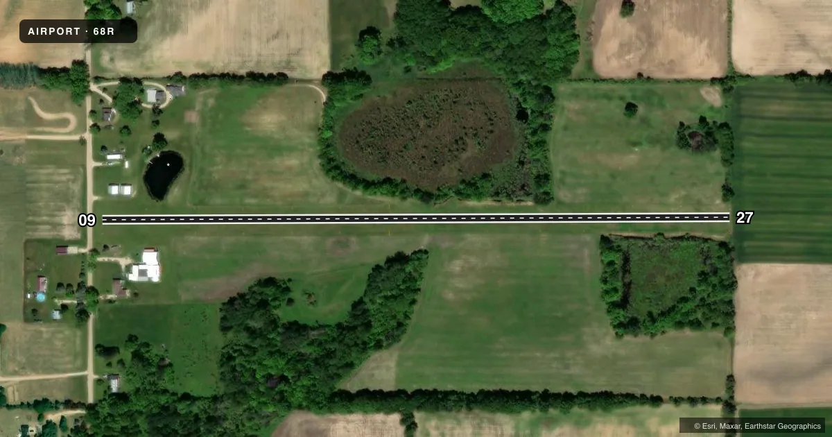
Airport sketch
Runways drawn to scale from FAA survey coordinates, rendered over satellite imagery. Not for navigation.
Approaches & charts
Services on the field
Fuel grades, oxygen, maintenance, ramp storage and lighting — as declared to the FAA by the airport operator.
Fuel & services
- Fuel
- Not available
- Airframe repair
- Major
- Power plant repair
- Major
Ramp & ground
- Transient storage
- Tie-down
- Wind indicator
- Yes
- Segmented circle
- No
Fuel & FBOs
Cheapest 100LL and Jet A on the field and nearby. Always confirm with the FBO before taxi.
Airport notes
Surface conditions, obstructions, local procedures, lighting outages and other notes published with each FAA cycle.
General notes
- TREES & BRUSH IN PRI SFC BOTH SIDES OF RWY.
- NO SNOW REMOVAL - CTC AMGR TO VFY FLD CONDS.
- DEER & LRG BIRDS ON & INVOF ARPT.
- FOR CD CTC GREAT LAKES APCH AT 269-459-3345, WHEN APCH CLSD CTC CLEVELAND ARTCC AT 440-774-0224/0490.
Approach & departure obstructions
- 09RWY & DTHR MKD WITH 3 FT YELLOW CONES.
- 273 FT YELLOW CONES.
- 09APCH RATIO 18:1 TO DTHR OVR +102 FT TREES, 1900 FT DIST, 125 FT L/R.
- 27APCH RATIO 20:1 TO DTHR BASED ON STRAIGHT OUT.
Other notes
- FOR SER CTC AMGR.
- PRVDD OBSTN IN RWY APCH SLP SFC BE REMOVED/LWRD OR THR DSPLCD, MKD, & LGTD FOR NGT OPS TO PRVD MNM 20:1 APCH SFC CLNC OVR OBSTNS; AREA 125 FT EITHER SIDE OF RCL & EXTDG TO A POINT 300 FT BYD RWY ENDS CLEAR OF OBSTN.
- 09/27ROLLING TRRN, SFC UNEVEN, & INTMT PATCHES OF MISG TURF.
VFR map & nearby airports
VFR sectional. Tap any ICAO chip to open that airport.
Key facts · 68R
Answer card- ICAO
- 68R
- Name
- HAMP
- Location
- ELWELL, MICHIGAN
- Elevation
- 825 ft MSL
- Traffic pattern altitude
- 1,825 ft MSL (1,000 AGL)
- Control tower
- Non-towered (use CTAF)
- Total runways
- 1
- Longest runway
- 09/27 · 2,580 ft
- Published ILS approaches
- 0
- Published frequencies
- 1
- Magnetic variation
- 4°
- Current flight rules
- VFR
- Current wind
- 270° at 13 kt
- Favored runway now
- RWY 27
HAMP Airport (68R) is in Elwell, Michigan. The field elevation is 825 ft MSL. It has one runway. Runway 09/27 is 2,580 ft of turf, which makes the field a short, soft-surface stop for light aircraft. There is no control tower. CTAF is 122.9.
No ILS approaches are published here. The pattern altitude is not published, so use the standard 1,000 ft AGL for light piston traffic unless the current Chart Supplement says otherwise. The published remarks matter here. Trees and brush are in the primary surface on both sides of the runway. The runway environment also includes rolling terrain. It has an uneven surface. Intermittent patches of missing turf are reported. Deer and large birds are reported on and near the airport. There is no snow removal. Contact the airport manager to verify field conditions before you go.
There are no on-field FBOs listed. For service, contact the airport manager. If you need clearance delivery, Great Lakes Approach is listed when it is open. When approach is closed, Cleveland ARTCC is the published contact. For a first-time arrival, plan for the turf surface, the short runway and the obstacle environment on both ends. Check the current Chart Supplement for any updated remarks before flying in.