METAR & TAF MI1
MI1 does not publish a METAR.
Showing the nearest reporting station: KMOP (MOUNT PLEASANT MUNI) · 8.5 NM away. Conditions at MI1 may differ.
METAR · KMOP
Observed 19:35Z
KMOP 271935Z AUTO 21015G21KT 10SM CLR 24/22 A2969 RMK AO2 T02390215
- Wind
- 210° @ 15G21 kt
- Visibility
- 10 SM
- Temp / Dew
- 24°C / 22°C
- Altimeter
- 29.69 inHg
- Clouds
- CLR
- Density alt
- 2,420 ft
- Ceiling
- Unlimited
- Rules
- VFR
Airport info & contacts
Manager on record, flight service, ARTCC, attendance schedule and pattern altitude — published by the FAA and refreshed every 28 days.
Location
- From city
- 5 NM SW
- VFR sectional
- DETROIT
- ARTCC
- ZOB · CLEVELAND
- NOTAM facility
- LAN (NOTAM-D)
Airport manager
- Name
- MICHAEL SCHULZ
- Phone
- 989-205-7039
- Address
- 1399 E DOHERTY RD, CLARE MI 48617-9146
Flight service · Hours
- FSS LAN
- LANSING1-800-WX-BRIEF
- Attendance
- Unattended
Frequencies
Tap any row to copy the frequency to your clipboard.
Runways & pattern
Full pagePattern entry · RWY 19
LEFT TRAFFICRunway end performance
| End | TORA | TODA | ASDA | LDA | VGSI | Approach lights | Obstruction |
|---|---|---|---|---|---|---|---|
| 01 | — | — | — | — | — | — | 15', road, 40' from thr, 0' R of cntrln, slope 2 |
Declared distances in feet. TORA = takeoff run available, TODA = takeoff distance, ASDA = accelerate-stop, LDA = landing distance.
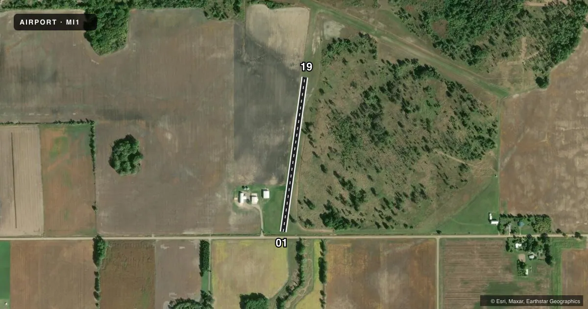
Airport sketch
Runways drawn to scale from FAA survey coordinates, rendered over satellite imagery. Not for navigation.
Approaches & charts
Services on the field
Fuel grades, oxygen, maintenance, ramp storage and lighting — as declared to the FAA by the airport operator.
Fuel & services
- Fuel
- Not available
- Oxygen (bottled)
- Not available
- Oxygen (bulk)
- Not available
- Airframe repair
- Not available
- Power plant repair
- Not available
- Other services
- AGRI
Ramp & ground
- Transient storage
- Tie-down
- Wind indicator
- Yes
- Segmented circle
- No
Fuel & FBOs
Cheapest 100LL and Jet A on the field and nearby. Always confirm with the FBO before taxi.
Airport notes
Surface conditions, obstructions, local procedures, lighting outages and other notes published with each FAA cycle.
General notes
- ARPT CLSD NOV-APR.
- DEER & LRG BIRDS ON & INVOF ARPT.
- FOR CD CTC GREAT LAKES APCH AT 269-459-3345, WHEN APCH CLSD CTC CLEVELAND ARTCC AT 440-774-0224/0490.
Runway surface & condition
- 01/19IREG, DEFINED BY MOWING.
VFR map & nearby airports
VFR sectional. Tap any ICAO chip to open that airport.
Key facts · MI1
Answer card- ICAO
- MI1
- Name
- DENTON FARMS
- Location
- CLARE, MICHIGAN
- Elevation
- 851 ft MSL
- Traffic pattern altitude
- 1,851 ft MSL (1,000 AGL)
- Control tower
- Non-towered (use CTAF)
- Total runways
- 1
- Longest runway
- 01/19 · 1,800 ft
- Published ILS approaches
- 0
- Published frequencies
- 1
- Magnetic variation
- –
- Current flight rules
- VFR
- Current wind
- 210° at 15 kt
- Favored runway now
- RWY 19
Denton Farms (MI1) is in Clare, Michigan. Field elevation is 851 ft MSL. The airport has one runway. Runway 01/19 is 1,800 ft long and turf. The runway is irregular and defined by mowing, so give yourself extra time to assess the surface before committing.
There is no control tower. CTAF is 122.9. No ILS approaches are published. Pattern altitude is not published, so use the standard 1,000 ft AGL for light piston operations unless the current Chart Supplement says otherwise. That puts the pattern at 1,851 ft MSL based on the listed field elevation.
There are no on-field FBOs listed. For clearance delivery, contact Great Lakes Approach at 269-459-3345. When approach is closed, contact Cleveland ARTCC at 440-774-0224 or 440-774-0490. The airport is closed from November through April. Deer and large birds are reported on and near the field. Plan for wildlife on taxi, takeoff and landing.
This is a turf strip with seasonal closure. Check the current Chart Supplement before you go. Verify the field status, then confirm the surface condition and any local operating notes with the airport operator if you are planning a visit.