METAR & TAF KGDW
Current METAR
Observed 20:15Z
KGDW 272015Z AUTO VRB02KT 10SM CLR 27/18 A2971 RMK AO2 PRESFR
- Wind
- VAR @ 2 kt
- Visibility
- 10 SM
- Temp / Dew
- 27°C / 18°C
- Altimeter
- 29.71 inHg
- Clouds
- CLR
- Density alt
- 2,660 ft
- Ceiling
- Unlimited
- Rules
- VFR
Airport info & contacts
Manager on record, flight service, ARTCC, attendance schedule and pattern altitude — published by the FAA and refreshed every 28 days.
Location
- From city
- 1 NM SE
- VFR sectional
- DETROIT
- ARTCC
- ZOB · CLEVELAND
- NOTAM facility
- GDW (NOTAM-D)
Airport manager
- Name
- MICHAEL HARGRAVE
- Phone
- 989-426-4201
- Address
- 735 S STATE ST, GLADWIN MI 48624-2258
Flight service · Hours
- FSS LAN
- LANSING1-800-WX-BRIEF
- Attendance
- 0900-1700
Frequencies
Tap any row to copy the frequency to your clipboard.
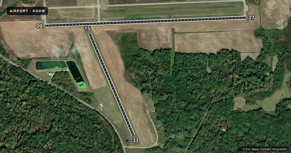
Runways & pattern
Full pagePattern entry · RWY 33
LEFT TRAFFIC| Runway | Heading (°M) | Length | Surface | Traffic |
|---|---|---|---|---|
| 09/27 | 84° / 264° | 4,699 ft | ASPH | Standard L |
| 15/33Favored | 153° / 333° | 2,580 ft | TURF | Standard L |
Runway end performance
| End | TORA | TODA | ASDA | LDA | VGSI | Approach lights | Obstruction |
|---|---|---|---|---|---|---|---|
| 09 | — | — | — | — | PAPI 4-box left(3.75°) | — | 34', tree, 856' from thr, 343' R of cntrln, slope 19 |
| 27 | — | — | — | — | PAPI 4-box left(3°) | — | — |
| 33 | — | — | — | — | — | — | 9', tree, 93' from thr, 133' R of cntrln, slope 10 |
Declared distances in feet. TORA = takeoff run available, TODA = takeoff distance, ASDA = accelerate-stop, LDA = landing distance.
Airport sketch
Runways drawn to scale from FAA survey coordinates, rendered over satellite imagery. Not for navigation.
Approaches & charts
Services on the field
Fuel grades, oxygen, maintenance, ramp storage and lighting — as declared to the FAA by the airport operator.
Fuel & services
- Fuel
- 100LLA+
Ramp & ground
- Transient storage
- Tie-down
- Landing fee
- No fee published
- Customs
- Not available
- Lighting schedule
- SEE RMK
- Beacon schedule
- SS-SR
- Beacon
- White / Green (civil land)(WG)
- Wind indicator
- Lighted
- Segmented circle
- Yes
Fuel & FBOs
Cheapest 100LL and Jet A on the field and nearby. Always confirm with the FBO before taxi.
Airport notes
Surface conditions, obstructions, local procedures, lighting outages and other notes published with each FAA cycle.
General notes
- DEER & LRG BIRDS ON & INVOF ARPT.
- UAS OPR WEST OF RWY 15/33.
- TRML BLDG ACES: 5-3-2-1-*.
- FOR CD CTC GREAT LAKES APCH AT 269-459-3345, WHEN APCH CLSD CTC CLEVELAND ARTCC AT 440-774-0224/0490.
Lighting notes
- ACTVT REIL RWY 09 & 27; PAPI RWY 09 & 27; MIRL RWY 09/27 - CTAF.
Fuel notes
- 100LL100LL AVBL H24 SELF SVC VIA CREDIT CARD. JET A+ AVBL FULL SVC DURG BUS HRS OR BY ARNGMT.
Runway surface & condition
- 15/33CLSD WHEN SNOW COVD EXC FOR SKI EQUIPPED ACFT.
Approach & departure obstructions
- 153 FT YELLOW CONES.
- 333 FT YELLOW CONES.
Other notes
- 1UNATNDD MAJOR HOLS. FOR SVC AFT HRS CALL AMGR CELL.
- MANAGERCELL 989-578-2174.
- OWNERCITY HALL.
VFR map & nearby airports
VFR sectional. Tap any ICAO chip to open that airport.
Key facts · KGDW
Answer card- ICAO
- KGDW
- Name
- GLADWIN ZETTEL MEML
- Location
- GLADWIN, MICHIGAN
- Elevation
- 774.1 ft MSL
- Traffic pattern altitude
- 1,774.1 ft MSL (1,000 AGL)
- Control tower
- Non-towered (use CTAF)
- Total runways
- 2
- Longest runway
- 09/27 · 4,699 ft
- Published ILS approaches
- 0
- Published frequencies
- 4
- Magnetic variation
- 4°
- Current flight rules
- VFR
- Current wind
- 000° at 2 kt
- Favored runway now
- RWY 33
Gladwin Zettel Memorial Airport sits in Gladwin, Michigan. Field elevation is 774.1 ft MSL. The airport has two runways. The longest is 09/27 at 4,699 ft. Runway 15/33 is turf and 2,580 ft. There is no control tower. No ILS approaches are published.
The pattern altitude is not published in the facts, so use the standard 1,000 ft AGL for light piston aircraft unless the current FAA Chart Supplement says otherwise. Runway 09/27 has medium intensity runway lights. It also has runway end identifier lights and precision approach path indicators. Runway 33 and runway 15 have 3-foot yellow cones marking the ends. Deer and large birds are reported on and near the airport. Unmanned aircraft system operations occur west of runway 15/33.
Gladwin Zettel Memorial Airport is unattended on major holidays. The terminal access code is 5-3-2-1-*. Gladwin Zettel Memorial Airport on the field carries 100LL and Jet A. 100LL is available 24 hours self-serve by credit card. Jet A is available full service during business hours or by arrangement. For clearance delivery, contact Great Lakes Approach. If approach is closed, use Cleveland ARTCC. A first-time pilot should plan for an uncontrolled field. Monitor CTAF 122.8. Verify current airport status before arrival.