METAR & TAF Y31
Current METAR
Observed 17:15Z
KY31 271715Z AUTO 31008G18KT 280V340 10SM CLR 30/19 A2972 RMK AO2 T02970193
- Wind
- 310° @ 8G18 kt
- Visibility
- 10 SM
- Temp / Dew
- 30°C / 19°C
- Altimeter
- 29.72 inHg
- Clouds
- CLR
- Density alt
- 3,142 ft
- Ceiling
- Unlimited
- Rules
- VFR
Airport info & contacts
Manager on record, flight service, ARTCC, attendance schedule and pattern altitude — published by the FAA and refreshed every 28 days.
Location
- From city
- 3 NM SE
- VFR sectional
- LAKE HURON
- ARTCC
- ZMP · MINNEAPOLIS
- NOTAM facility
- Y31 (NOTAM-D)
Airport manager
- Name
- BEN EVERGREEN
- Phone
- 989-345-1453
- Address
- PO BOX 183, WEST BRANCH MI 48661-0183
Flight service · Hours
- FSS LAN
- LANSING1-800-WX-BRIEF
- Attendance
- MON-FRI · 0800-1700
- SAT-SUN · ON CALL
Frequencies
Tap any row to copy the frequency to your clipboard.
Runways & pattern
Full pagePattern entry · RWY 27
LEFT TRAFFICRunway end performance
| End | TORA | TODA | ASDA | LDA | VGSI | Approach lights | Obstruction |
|---|---|---|---|---|---|---|---|
| 09 | — | — | — | — | PAPI 4-box left(3°) | — | — |
| 27 | — | — | — | — | PAPI 4-box left(3°) | — | 70', tree, 2379' from thr, 592' R of cntrln, slope 31 |
Declared distances in feet. TORA = takeoff run available, TODA = takeoff distance, ASDA = accelerate-stop, LDA = landing distance.
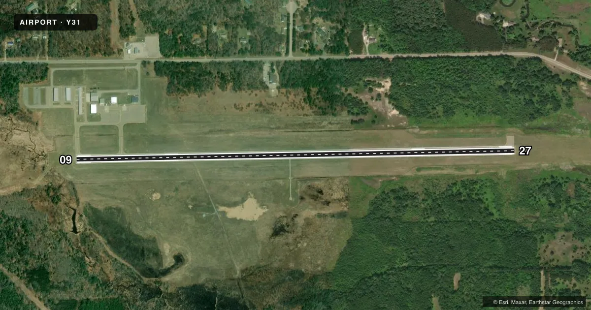
Airport sketch
Runways drawn to scale from FAA survey coordinates, rendered over satellite imagery. Not for navigation.
Approaches & charts
Services on the field
Fuel grades, oxygen, maintenance, ramp storage and lighting — as declared to the FAA by the airport operator.
Fuel & services
- Fuel
- 100LLA+
- Oxygen (bottled)
- Not available
- Oxygen (bulk)
- Not available
- Airframe repair
- Not available
- Power plant repair
- Not available
Ramp & ground
- Transient storage
- Tie-down
- Hangar
- Landing fee
- No fee published
- Customs
- Not available
- Lighting schedule
- SEE RMK
- Beacon schedule
- SS-SR
- Beacon
- White / Green (civil land)(WG)
- Wind indicator
- Lighted
- Segmented circle
- Yes
Fuel & FBOs
Cheapest 100LL and Jet A on the field and nearby. Always confirm with the FBO before taxi.
Airport notes
Surface conditions, obstructions, local procedures, lighting outages and other notes published with each FAA cycle.
General notes
- ADMIN BLDG ACES: 5-3-2-1-#.
- FOR CD CTC MINNEAPOLIS ARTCC AT 651-463-5588.
- DEER & LRG BIRDS ON & INVOF ARPT.
Lighting notes
- ACTVT REIL RWY 09 & 27; PAPI RWY 09 & 27; MIRL RWY 09/27 - CTAF. PAPI RWY 09 & 27 OPR CONSLY SR-SS.
Other notes
- 2FOR SVC AFT HRS CALL AMGR SUBJ CALL-IN FEE.
VFR map & nearby airports
VFR sectional. Tap any ICAO chip to open that airport.
Key facts · Y31
Answer card- ICAO
- Y31
- Name
- WEST BRANCH COMMUNITY
- Location
- WEST BRANCH, MICHIGAN
- Elevation
- 882.1 ft MSL
- Traffic pattern altitude
- 1,882.1 ft MSL (1,000 AGL)
- Control tower
- Non-towered (use CTAF)
- Total runways
- 1
- Longest runway
- 09/27 · 5,000 ft
- Published ILS approaches
- 0
- Published frequencies
- 2
- Magnetic variation
- 6°
- Current flight rules
- VFR
- Current wind
- 310° at 8 kt
- Favored runway now
- RWY 27
West Branch Community Airport sits in West Branch, Michigan. Field elevation is 882.1 ft MSL. The airport has one runway. Runway 09/27 is 5,000 ft long with asphalt pavement. There is no control tower. CTAF and UNICOM are both 122.8. No ILS approaches are published here.
Pattern altitude is not published. Use the standard 1,000 ft AGL for light piston operations unless the current Chart Supplement says otherwise. That puts the traffic pattern at about 1,882 ft MSL based on the field elevation. Verify before you fly. Evergreen Aviation is on the field. It carries 100LL and Jet A. The published remarks also note medium intensity runway lights on 09/27 that are controlled by CTAF. PAPI is available on both runway ends. The runway end identifier lights are active on 09 and 27.
This is a non-towered field with wildlife in the area. Deer and large birds are reported on and near the airport. Plan for that on taxi, takeoff and final. For clearance delivery, contact Minneapolis ARTCC at 651-463-5588. If you need after-hours service, call the airport manager first. A call-in fee may apply.