METAR & TAF M47
M47 does not publish a METAR.
Showing the nearest reporting station: KOSC (OSCODA/WURTSMITH) · 24.3 NM away. Conditions at M47 may differ.
METAR · KOSC
Observed 17:15Z
KOSC 271715Z AUTO 08016G21KT 10SM -RA SCT028 SCT046 OVC070 21/17 A2976 RMK AO2 PK WND 08031/22
- Wind
- 080° @ 16G21 kt
- Visibility
- 10 SM
- Temp / Dew
- 21°C / 17°C
- Altimeter
- 29.76 inHg
- Clouds
- OVC
- Density alt
- 2,042 ft
- Ceiling
- 7,000 ft AGL
- Rules
- VFR
Airport info & contacts
Manager on record, flight service, ARTCC, attendance schedule and pattern altitude — published by the FAA and refreshed every 28 days.
Location
- From city
- 6 NM W
- VFR sectional
- LAKE HURON
- ARTCC
- ZMP · MINNEAPOLIS
- NOTAM facility
- LAN (NOTAM-D)
Airport manager
- Name
- THOMAS GREEN
- Phone
- 810-348-3536
- Address
- 6209 SEYMOUR RD, SWARTZ CREEK MI 48473-7628
Flight service · Hours
- FSS LAN
- LANSING1-800-WX-BRIEF
- Attendance
- IREG
Frequencies
Tap any row to copy the frequency to your clipboard.
Runways & pattern
Full pagePattern entry · RWY 05W
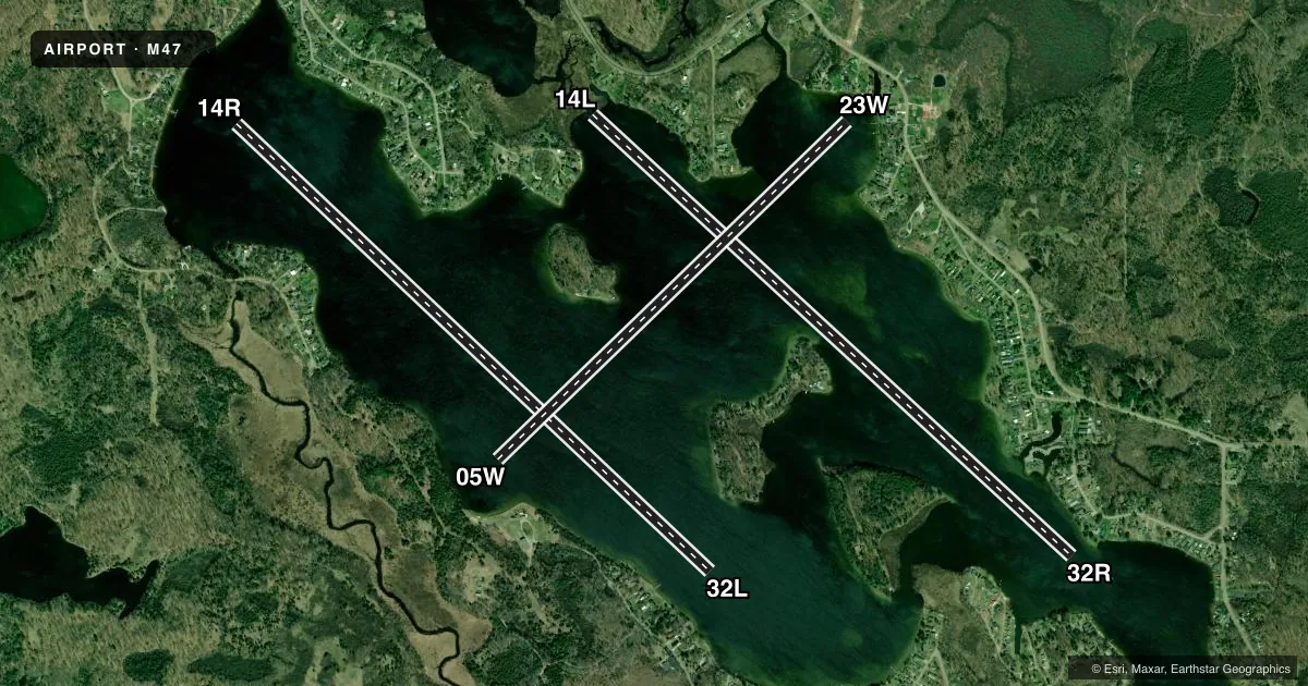
LEFT TRAFFICAirport sketch
Runways drawn to scale from FAA survey coordinates, rendered over satellite imagery. Not for navigation.
Approaches & charts
Services on the field
Fuel grades, oxygen, maintenance, ramp storage and lighting — as declared to the FAA by the airport operator.
Fuel & services
- Fuel
- Not available
Ramp & ground
- Transient storage
- Not published
- Wind indicator
- Yes
Fuel & FBOs
Cheapest 100LL and Jet A on the field and nearby. Always confirm with the FBO before taxi.
Airport notes
Surface conditions, obstructions, local procedures, lighting outages and other notes published with each FAA cycle.
General notes
- FOR CD CTC MINNEAPOLIS ARTCC AT 651-463-5588.
Other notes
- DUE TO TREES IN CLOSE PROXIMITY WINDSOCK UNRELIABLE IN ALL DIRECTIONS.
- OWNERDOCKING FAC.
VFR map & nearby airports
VFR sectional. Tap any ICAO chip to open that airport.
Key facts · M47
Answer card- ICAO
- M47
- Name
- SAGE LAKE
- Location
- HALE, MICHIGAN
- Elevation
- 906 ft MSL
- Traffic pattern altitude
- 1,906 ft MSL (1,000 AGL)
- Control tower
- Non-towered (use CTAF)
- Total runways
- 3
- Longest runway
- 14R/32L · 6,700 ft
- Published ILS approaches
- 0
- Published frequencies
- 1
- Magnetic variation
- –
- Current flight rules
- VFR
- Current wind
- 080° at 16 kt
- Favored runway now
- RWY 05W
Sage Lake (M47) sits in Hale, Michigan. Field elevation is 906 ft MSL. This is a water airport with three runways. The longest are 14L/32R and 14R/32L at 6,700 ft. The third runway is 05W/23W at 5,000 ft. There is no control tower. CTAF is 122.9. No ILS approaches are published here.
Pattern altitude is not published. Use 1,000 ft AGL for light piston traffic unless the current Chart Supplement or local procedures say otherwise. That puts the working pattern around 1,906 ft MSL. The published remarks say the windsock can be unreliable because of trees close in all directions. Do not lean on it alone. The field also has a docking facility. For clearance delivery, contact Minneapolis ARTCC at 651-463-5588.
There are no on-field FBOs listed in the facts. Contact the airport operator directly before arrival if you need current services. This is a non-towered water field, so expect self-announced traffic on CTAF and keep a close scan for other seaplanes. Check the current Chart Supplement for any local procedures or restrictions before you go.