METAR & TAF H80
H80 does not publish a METAR.
Showing the nearest reporting station: KOSC (OSCODA/WURTSMITH) · 16.6 NM away. Conditions at H80 may differ.
METAR · KOSC
Observed 23:35Z
KOSC 272335Z AUTO 22006KT 10SM -RA SCT120 25/19 A2964 RMK AO2
- Wind
- 220° @ 6 kt
- Visibility
- 10 SM
- Temp / Dew
- 25°C / 19°C
- Altimeter
- 29.64 inHg
- Clouds
- SCT
- Density alt
- 2,576 ft
- Ceiling
- Unlimited
- Rules
- VFR
Airport info & contacts
Manager on record, flight service, ARTCC, attendance schedule and pattern altitude — published by the FAA and refreshed every 28 days.
Location
- From city
- 2 NM ESE
- VFR sectional
- LAKE HURON
- ARTCC
- ZMP · MINNEAPOLIS
- NOTAM facility
- LAN (NOTAM-D)
Airport manager
- Name
- JEFF BLUST
- Phone
- 810-599-1930
- Address
- 5932 CURTIS RD, HALE MI 48739-8542
Flight service · Hours
- FSS LAN
- LANSING1-800-WX-BRIEF
- Attendance
- Unattended
Frequencies
Tap any row to copy the frequency to your clipboard.
Runways & pattern
Full pagePattern entry · RWY 26
LEFT TRAFFICRunway end performance
| End | TORA | TODA | ASDA | LDA | VGSI | Approach lights | Obstruction |
|---|---|---|---|---|---|---|---|
| 08 | — | — | — | — | — | — | 30', trees, 10' from thr, 60' R of cntrln, slope 0 |
| 26 | — | — | — | — | — | — | 54', tree, 517' from thr, 134' R of cntrln, slope 9 |
Declared distances in feet. TORA = takeoff run available, TODA = takeoff distance, ASDA = accelerate-stop, LDA = landing distance.
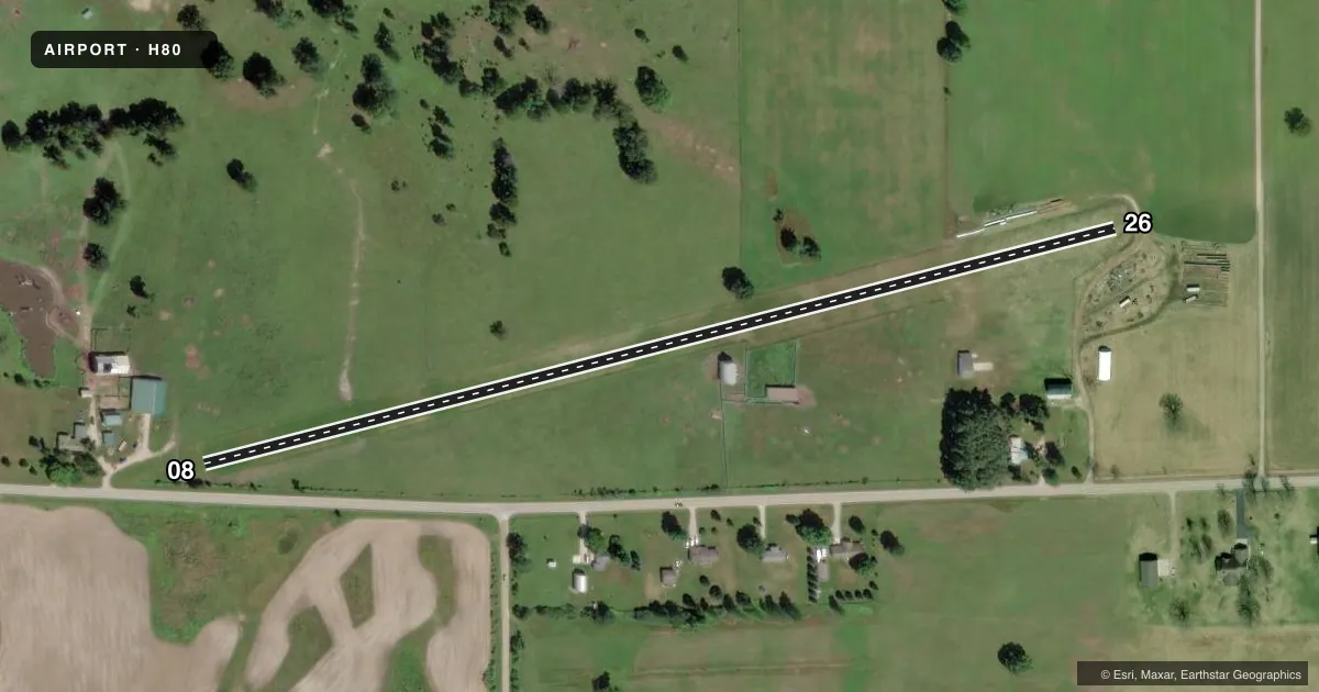
Airport sketch
Runways drawn to scale from FAA survey coordinates, rendered over satellite imagery. Not for navigation.
Approaches & charts
Services on the field
Fuel grades, oxygen, maintenance, ramp storage and lighting — as declared to the FAA by the airport operator.
Fuel & services
- Fuel
- Not available
Ramp & ground
- Transient storage
- Tie-down
- Wind indicator
- Yes
- Segmented circle
- Yes
Fuel & FBOs
Cheapest 100LL and Jet A on the field and nearby. Always confirm with the FBO before taxi.
Airport notes
Surface conditions, obstructions, local procedures, lighting outages and other notes published with each FAA cycle.
General notes
- ARPT CLSD NOV-APR.
- ELECTRIC PERIMETER FENCE.
- RWY 08/26: LRG HAY BALES ALG NORTH EDGE; +30 FT BLDG, 72 FT SOUTH OF CNTRLN; +60 FT TREE, 96 FT NORTH OF CNTRLN; FARM EQPT PARKED NEAR RWY ENDS.
- LOW LVL MIL JETS OPR NEAR ARPT; ARPT LCTD WI PIKE WEST MOA & 3 MILES FM MTR VR1624.
- RWY 08: 130 FT UNMKD PLINE, 0.85 MILE FM RWY END.
- FOR CD CTC MINNEAPOLIS ARTCC AT 651-463-5588.
- DEER & LRG BIRDS ON & INVOF ARPT.
Approach & departure obstructions
- 08RWY & DTHR MKD WITH 3 FT YELLOW CONES.
- 263 FT YELLOW CONES.
- 08CTLG OBSTN EXCEEDS A 45 DEG SLP. APCH RATIO 20:1 TO DTHR.
- 26APCH RATIO 20:1 TO DTHR.
Other notes
- PRVDD AREA 125 FT EITHER SIDE OF RWY CNTRLN & 200 FT OFF RWY ENDS BE CLEAR OF OBSTN; OBSTN IN RWY APCH SLP SFC BE REMOVED/LWRD OR RWY THR BE DSPLCD OR REALIGNED TO PRVD 20:1 APCH CLNC OVR OBSTN; SFC AREA 60 FT EITHER SIDE OF RWY CNTRLN & 240 FT OFF RWY ENDS SUITABLE TO RDCG RISK OF DMG TO ACFT.
- 08/26WEST END MAY BE SOFT IN SPRING - CTC AMGR FOR FLD CONDS.
VFR map & nearby airports
VFR sectional. Tap any ICAO chip to open that airport.
Key facts · H80
Answer card- ICAO
- H80
- Name
- FIELD OF DREAMS
- Location
- HALE, MICHIGAN
- Elevation
- 830 ft MSL
- Traffic pattern altitude
- 1,830 ft MSL (1,000 AGL)
- Control tower
- Non-towered (use CTAF)
- Total runways
- 1
- Longest runway
- 08/26 · 2,400 ft
- Published ILS approaches
- 0
- Published frequencies
- 1
- Magnetic variation
- 6°
- Current flight rules
- VFR
- Current wind
- 220° at 6 kt
- Favored runway now
- RWY 26
Field of Dreams is in Hale, Michigan. The field elevation is 830 ft MSL. It has one runway, 08/26. The longest runway is 2,400 ft of turf. There is no control tower. CTAF is 122.9. No ILS approaches are published.
The pattern altitude is not published. Use the standard 1,000 ft AGL pattern for light piston operations unless the current FAA Chart Supplement says otherwise. The airport is closed from November through April, so plan around the seasonal closure before you launch. Published remarks also call out deer and large birds in the area. Runway 08 has a power line about 0.85 mile from the runway end. The west end may be soft in spring. The runway environment also includes hay bales, a building south of the centerline, a tree north of the centerline and farm equipment near the ends.
There are no on-field FBOs listed. Contact the airport operator or the FBO directly by phone before arrival if you need current services. For clearance delivery, Minneapolis ARTCC can be reached at 651-463-5588. The runway is turf, so check field conditions before you go. The published remarks also note cones marking the runway and displaced threshold areas on both ends.