METAR & TAF 6Y6
6Y6 does not publish a METAR.
Showing the nearest reporting station: KHTL (ROSCOMMON COUNTY/BLODGETT MEML) · 11.5 NM away. Conditions at 6Y6 may differ.
METAR · KHTL
Observed 18:53Z
KHTL 271853Z AUTO VRB04KT 10SM CLR 27/19 A2973 RMK AO2 SLP062 T02720194
- Wind
- VAR @ 4 kt
- Visibility
- 10 SM
- Temp / Dew
- 27°C / 19°C
- Altimeter
- 29.73 inHg
- Clouds
- CLR
- Density alt
- 3,161 ft
- Ceiling
- Unlimited
- Rules
- VFR
Airport info & contacts
Manager on record, flight service, ARTCC, attendance schedule and pattern altitude — published by the FAA and refreshed every 28 days.
Location
- From city
- 1 NM SE
- VFR sectional
- LAKE HURON
- ARTCC
- ZMP · MINNEAPOLIS
- NOTAM facility
- LAN (NOTAM-D)
Airport manager
- Name
- ROBERT COULTER
- Phone
- 323-974-0409
- Address
- 9376 ROSE DR, SAINT HELEN MI 48656-9355
Flight service · Hours
- FSS LAN
- LANSING1-800-WX-BRIEF
- Attendance
- Unattended
Frequencies
Tap any row to copy the frequency to your clipboard.
Runways & pattern
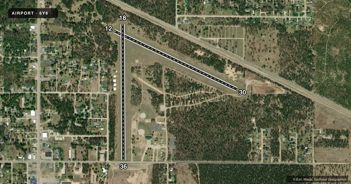
Full pagePattern entry · RWY 36
LEFT TRAFFIC| Runway | Heading (°M) | Length | Surface | Traffic |
|---|---|---|---|---|
| 18/36Favored | 175° / 355° | 2,600 ft | TURF | Standard L |
| 12/30 | 110° / 290° | 2,600 ft | TURF | Standard L |
Runway end performance
| End | TORA | TODA | ASDA | LDA | VGSI | Approach lights | Obstruction |
|---|---|---|---|---|---|---|---|
| 18 | — | — | — | — | — | — | 25', trees, 60' from thr, 75' R of cntrln, slope 2 |
| 36 | — | — | — | — | — | — | 18', road, 40' from thr, 125' R of cntrln, slope 2 |
| 12 | — | — | — | — | — | — | 67', trees, 195' from thr, 30' R of cntrln, slope 2 |
| 30 | — | — | — | — | — | — | 15', road, 0' from thr, 60' R of cntrln, slope 0 |
Declared distances in feet. TORA = takeoff run available, TODA = takeoff distance, ASDA = accelerate-stop, LDA = landing distance.
Airport sketch
Runways drawn to scale from FAA survey coordinates, rendered over satellite imagery. Not for navigation.
Approaches & charts
Services on the field
Fuel grades, oxygen, maintenance, ramp storage and lighting — as declared to the FAA by the airport operator.
Fuel & services
- Fuel
- Not available
- Oxygen (bottled)
- Not available
- Oxygen (bulk)
- Not available
- Airframe repair
- Not available
- Power plant repair
- Not available
Ramp & ground
- Transient storage
- Tie-down
- Landing fee
- No fee published
- Customs
- Not available
- Wind indicator
- Yes
- Segmented circle
- Yes
Fuel & FBOs
Cheapest 100LL and Jet A on the field and nearby. Always confirm with the FBO before taxi.
Airport notes
Surface conditions, obstructions, local procedures, lighting outages and other notes published with each FAA cycle.
General notes
- ARPT CLSD DEC-MAR & WHEN SNOW COVD.
- HNGRS LCTD 135 FT WEST OF RWY 18/36 CNTRLN.
- FOR CD CTC MINNEAPOLIS ARTCC AT 651-463-5588.
- DEER & LRG BIRDS ON & INVOF ARPT.
Approach & departure obstructions
- 12RWY & DTHR MKD WITH 3 FT YELLOW CONES.
- 18RWY & DTHR MKD WITH 3 FT YELLOW CONES.
- 30RWY & DTHR MKD WITH 3 FT YELLOW CONES.
- 36RWY & DTHR MKD WITH 3 FT YELLOW CONES.
- 12APCH RATIO 6:1 TO DTHR OVR +64 FT TREE, 1030 FT DIST, 95 FT R.
- 18APCH RATIO 19:1 TO DTHR OVR +71 FT TREE, 1398 FT DIST, 10 FT R.
- 30APCH RATIO 20:1 TO DTHR.
- 36APCH RATIO 20:1 TO DTHR.
VFR map & nearby airports
VFR sectional. Tap any ICAO chip to open that airport.
Key facts · 6Y6
Answer card- ICAO
- 6Y6
- Name
- ST HELEN
- Location
- ST HELEN, MICHIGAN
- Elevation
- 1,198 ft MSL
- Traffic pattern altitude
- 2,198 ft MSL (1,000 AGL)
- Control tower
- Non-towered (use CTAF)
- Total runways
- 2
- Longest runway
- 18/36 · 2,600 ft
- Published ILS approaches
- 0
- Published frequencies
- 1
- Magnetic variation
- 5°
- Current flight rules
- VFR
- Current wind
- 000° at 4 kt
- Favored runway now
- RWY 36
St Helen (6Y6) sits in St Helen, Michigan. Field elevation is 1,198 ft MSL. The airport has two runways. The longest is 2,600 ft. Both runways are turf. There is no control tower. CTAF is 122.9.
No ILS approaches are published here. The pattern altitude is not published, so use standard 1,000 ft AGL unless the current FAA Chart Supplement says otherwise. The field is closed December through March and when snow covered. Check status before you launch. Published remarks also call out displaced thresholds marked with 3-foot yellow cones. Runway 12 has a tree near the approach path. Runway 18 has a tree near the approach path as well. Deer and large birds are reported on and near the airport.
There are no on-field FBOs listed, so plan fuel and services with the airport operator or the FBO directly by phone before arrival. For clearance delivery, contact Minneapolis ARTCC at 651-463-5588. This is a non-towered turf field with seasonal closure and obstacle notes that matter on short final. A first-time pilot should review the current Chart Supplement, confirm runway condition and pay close attention to the displaced thresholds and wildlife.