METAR & TAF 5Y2
5Y2 does not publish a METAR.
Showing the nearest reporting station: KHTL (ROSCOMMON COUNTY/BLODGETT MEML) · 5.5 NM away. Conditions at 5Y2 may differ.
METAR · KHTL
Observed 12:53Z
KHTL 271253Z AUTO 24007KT 10SM FEW028 FEW048 24/22 A2978 RMK AO2 SLP078 T02440217
- Wind
- 240° @ 7 kt
- Visibility
- 10 SM
- Temp / Dew
- 24°C / 22°C
- Altimeter
- 29.78 inHg
- Clouds
- FEW
- Density alt
- 2,698 ft
- Ceiling
- Unlimited
- Rules
- VFR
Airport info & contacts
Manager on record, flight service, ARTCC, attendance schedule and pattern altitude — published by the FAA and refreshed every 28 days.
Location
- From city
- 1 NM W
- VFR sectional
- LAKE HURON
- ARTCC
- ZMP · MINNEAPOLIS
- NOTAM facility
- LAN (NOTAM-D)
Airport manager
- Name
- CHRIS AMBROSE
- Phone
- 616-540-1324
- Address
- 125 CRISTI LN, HOUGHTON LAKE MI 48629-9683
Flight service · Hours
- FSS LAN
- LANSING1-800-WX-BRIEF
- Attendance
- Unattended
Frequencies
Tap any row to copy the frequency to your clipboard.
Runways & pattern
Full pagePattern entry · RWY 16
LEFT TRAFFICRunway end performance
| End | TORA | TODA | ASDA | LDA | VGSI | Approach lights | Obstruction |
|---|---|---|---|---|---|---|---|
| 16 | — | — | — | — | — | — | 53', tree, 0' from thr, 77' R of cntrln, slope 0 |
| 34 | — | — | — | — | — | — | 23', trees, 64' from thr, 60' R of cntrln, slope 2 |
Declared distances in feet. TORA = takeoff run available, TODA = takeoff distance, ASDA = accelerate-stop, LDA = landing distance.
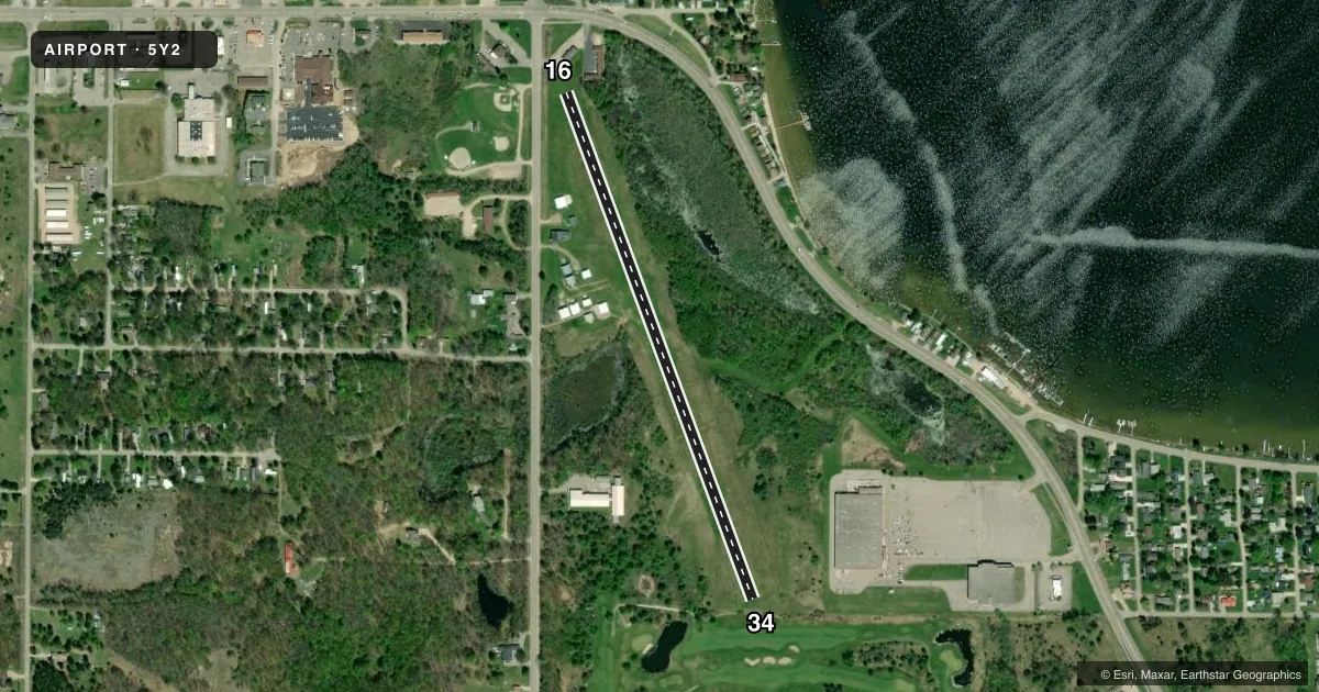
Airport sketch
Runways drawn to scale from FAA survey coordinates, rendered over satellite imagery. Not for navigation.
Approaches & charts
Services on the field
Fuel grades, oxygen, maintenance, ramp storage and lighting — as declared to the FAA by the airport operator.
Fuel & services
- Fuel
- Not available
- Oxygen (bottled)
- Not available
- Oxygen (bulk)
- Not available
- Airframe repair
- Not available
- Power plant repair
- Not available
Ramp & ground
- Transient storage
- Tie-down
- Landing fee
- No fee published
- Customs
- Not available
- Wind indicator
- Yes
- Segmented circle
- Yes
Fuel & FBOs
Cheapest 100LL and Jet A on the field and nearby. Always confirm with the FBO before taxi.
Airport notes
Surface conditions, obstructions, local procedures, lighting outages and other notes published with each FAA cycle.
General notes
- SNOW REMOVAL IREG - CTC AMGR AT 616-540-1324 TO VFY CONDS.
- DEER & LRG BIRDS ON & INVOF ARPT.
- FOR CD CTC MINNEAPOLIS ARTCC AT 651-463-5588.
Approach & departure obstructions
- 16RWY & DTHR MKD WITH 3 FT YELLOW CONES.
- 34RWY & DTHR MKD WITH 3 FT YELLOW CONES.
- 16CTLG OBSTN EXCEEDS A 45 DEG SLP. APCH RATIO 20:1 TO DTHR.
- 34APCH RATIO 18:1 TO DTHR OVR +88 FT TREES, 1795 FT DIST, 20 FT L.
Other notes
- NON-COMPLIANCE FAR 157.
- PILOTS MUST SUP ROPES.
VFR map & nearby airports
VFR sectional. Tap any ICAO chip to open that airport.
Key facts · 5Y2
Answer card- ICAO
- 5Y2
- Name
- HOUGHTON LAKE STATE
- Location
- HOUGHTON LAKE HEIGHTS, MICHIGAN
- Elevation
- 1,165 ft MSL
- Traffic pattern altitude
- 2,165 ft MSL (1,000 AGL)
- Control tower
- Non-towered (use CTAF)
- Total runways
- 1
- Longest runway
- 16/34 · 2,750 ft
- Published ILS approaches
- 0
- Published frequencies
- 1
- Magnetic variation
- 5°
- Current flight rules
- VFR
- Current wind
- 240° at 7 kt
- Favored runway now
- RWY 16
Houghton Lake State Airport sits in Houghton Lake Heights, Michigan. Field elevation is 1,165 ft MSL. The airport has one runway. Runway 16/34 is 2,750 ft of turf. That is the longest runway on the field. There is no control tower. CTAF is 122.9.
No ILS approaches are published here. Pattern altitude is not published. Use the standard 1,000 ft AGL pattern unless local guidance says otherwise. That puts the pattern at 2,165 ft MSL based on the field elevation. The published remarks matter here. Both runway ends have marked displaced thresholds with cone markings. The approach paths also have obstruction notes, including trees near Runway 34 and a steep obstruction profile on Runway 16. Pilots must support ropes. Snow removal is irregular, so check conditions before you go. Deer and large birds are reported on and near the airport.
There are no on-field FBOs listed in the facts. Contact the airport manager at 616-540-1324 for field condition updates. For clearance delivery, contact Minneapolis ARTCC at 651-463-5588. This is a turf strip with published obstruction notes, so a first-time pilot should plan a careful look at runway condition, threshold markings and wind before committing.