METAR & TAF 6Y0
6Y0 does not publish a METAR.
Showing the nearest reporting station: KHTL (ROSCOMMON COUNTY/BLODGETT MEML) · 15.3 NM away. Conditions at 6Y0 may differ.
METAR · KHTL
Observed 19:53Z
KHTL 271953Z AUTO 21009KT 10SM CLR 27/19 A2973 RMK AO2 SLP063 T02670194
- Wind
- 210° @ 9 kt
- Visibility
- 10 SM
- Temp / Dew
- 27°C / 19°C
- Altimeter
- 29.73 inHg
- Clouds
- CLR
- Density alt
- 3,177 ft
- Ceiling
- Unlimited
- Rules
- VFR
Airport info & contacts
Manager on record, flight service, ARTCC, attendance schedule and pattern altitude — published by the FAA and refreshed every 28 days.
Location
- From city
- 0 NM ESE
- VFR sectional
- LAKE HURON
- ARTCC
- ZMP · MINNEAPOLIS
- NOTAM facility
- LAN (NOTAM-D)
Airport manager
- Name
- LOIS WHIPPLE
- Phone
- 231-229-4232
- Address
- 4840 E MOORESTOWN RD, LAKE CITY MI 49651-9739
Flight service · Hours
- FSS LAN
- LANSING1-800-WX-BRIEF
- Attendance
- APR-NOV · DAWN-DUSK
Frequencies
Tap any row to copy the frequency to your clipboard.
Runways & pattern
Full pagePattern entry · RWY 21
LEFT TRAFFIC| Runway | Heading (°M) | Length | Surface | Traffic |
|---|---|---|---|---|
| 03/21Favored | 20° / 200° | 2,800 ft | TURF | Standard L |
| 09/27 | 86° / 266° | 2,600 ft | TURF | Standard L |
Runway end performance
| End | TORA | TODA | ASDA | LDA | VGSI | Approach lights | Obstruction |
|---|---|---|---|---|---|---|---|
| 03 | — | — | — | — | — | — | 50', trees, 135' from thr, 115' R of cntrln, slope 2 |
| 21 | — | — | — | — | — | — | 15', road, 0' from thr, 80' R of cntrln, slope 0 |
| 09 | — | — | — | — | — | — | 55', trees, 100' from thr, 80' R of cntrln, slope 1 |
| 27 | — | — | — | — | — | — | 15', road, 34' from thr, 128' R of cntrln, slope 2 |
Declared distances in feet. TORA = takeoff run available, TODA = takeoff distance, ASDA = accelerate-stop, LDA = landing distance.
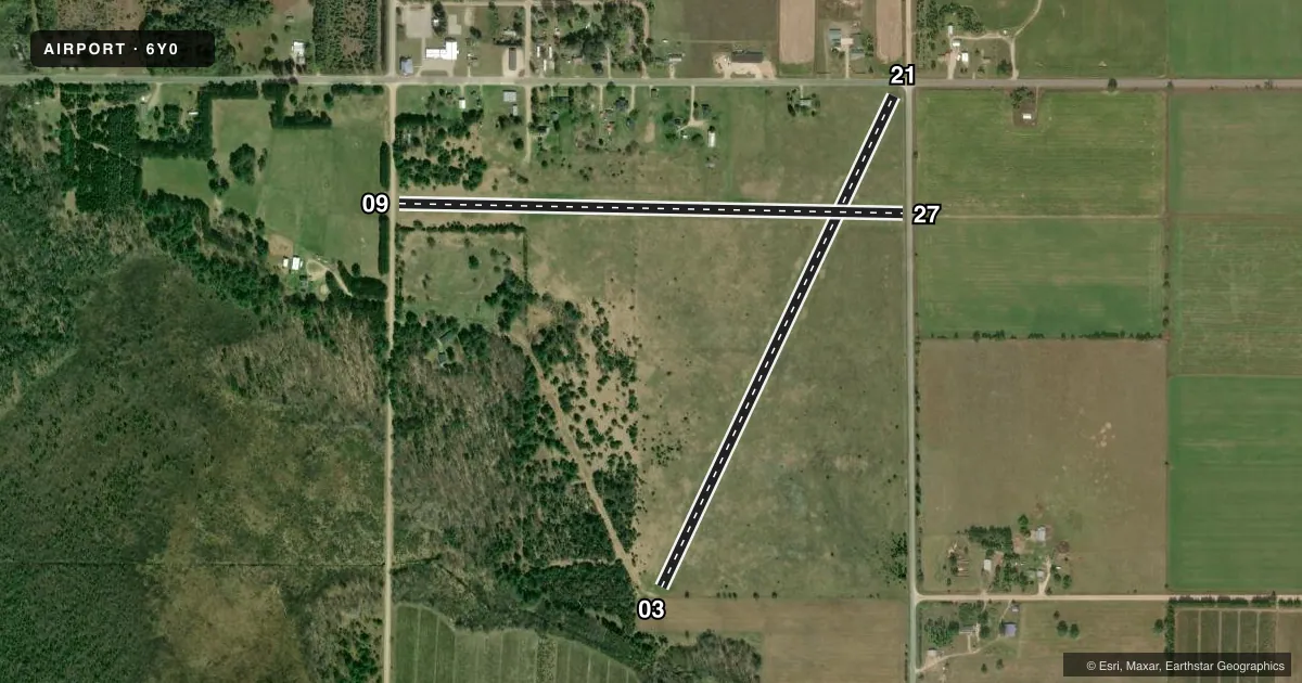
Airport sketch
Runways drawn to scale from FAA survey coordinates, rendered over satellite imagery. Not for navigation.
Approaches & charts
Services on the field
Fuel grades, oxygen, maintenance, ramp storage and lighting — as declared to the FAA by the airport operator.
Fuel & services
- Fuel
- Not available
- Oxygen (bottled)
- Not available
- Oxygen (bulk)
- Not available
- Airframe repair
- Not available
- Power plant repair
- Not available
Ramp & ground
- Transient storage
- Tie-down
- Landing fee
- No fee published
- Customs
- Not available
- Wind indicator
- Yes
- Segmented circle
- Yes
Fuel & FBOs
Cheapest 100LL and Jet A on the field and nearby. Always confirm with the FBO before taxi.
Airport notes
Surface conditions, obstructions, local procedures, lighting outages and other notes published with each FAA cycle.
General notes
- NO SNOW REMOVAL, WINTER OPS FOR SKI-EQUIPPED ACFT ONLY.
- FOR CD CTC MINNEAPOLIS ARTCC AT 651-463-5588.
- DEER, LRG BIRDS, & WILDLIFE ON & INVOF ARPT.
- RWY 21: UNMKD PLINES ON APCH.
Approach & departure obstructions
- 03RWY & DTHR MKD WITH 3 FT YELLOW CONES.
- 09RWY & DTHR MKD WITH 3 FT YELLOW CONES.
- 21RWY & DTHR MKD WITH 3 FT YELLOW CONES.
- 27RWY & DTHR MKD WITH 3 FT YELLOW CONES.
- 03APCH SLP 20:1 TO DTHR OVR +50 FT TREES, 135 FT DIST, 115 FT L.
- 09+55 FT TREES, 100 FT DIST, 80 FT L/R; +15 FT ROAD, 28 FT DIST, 0 FT B.
- 21CTLG OBSTN EXCEEDS A 45 DEG SLP. ROAD, 35 FT DIST, 80 FT L.
Other notes
- ROPES NOT PRVDD.
- MANAGEREVE 231-224-4443.
VFR map & nearby airports
VFR sectional. Tap any ICAO chip to open that airport.
Key facts · 6Y0
Answer card- ICAO
- 6Y0
- Name
- MOORESTOWN AIRPARK
- Location
- MOORESTOWN, MICHIGAN
- Elevation
- 1,211 ft MSL
- Traffic pattern altitude
- 2,211 ft MSL (1,000 AGL)
- Control tower
- Non-towered (use CTAF)
- Total runways
- 2
- Longest runway
- 03/21 · 2,800 ft
- Published ILS approaches
- 0
- Published frequencies
- 1
- Magnetic variation
- 5°
- Current flight rules
- VFR
- Current wind
- 210° at 9 kt
- Favored runway now
- RWY 21
Moorestown Airpark sits in Moorestown, Michigan. Field elevation is 1,211 ft MSL. The airport has two turf runways. The longest is 2,800 ft on runway 03/21. Runway 09/27 is 2,600 ft. There is no control tower. CTAF is 122.9.
No ILS approaches are published here. Pattern altitude is not published, so use the standard 1,000 ft AGL for light piston planning unless the current FAA Chart Supplement says otherwise. That puts the traffic pattern at about 2,211 ft MSL based on field elevation, but verify before you fly.
There are no on-field FBOs listed. Contact the airport operator directly before arrival if you need fuel or local services. Published remarks say winter operations are for ski-equipped aircraft only because no snow removal is provided. That matters here. Large birds are also reported on and near the field. Several runway remarks mention yellow cones marking the runway and displaced threshold. Runway 03 has trees near the approach path. Runway 09 has trees close in on the approach side and off the sides. Runway 21 also has an approach note tied to trees off the end. This is a short turf field with nearby obstacles, so plan a careful arrival and check the current FAA Chart Supplement before departure.