METAR & TAF Y91
Y91 does not publish a METAR.
Showing the nearest reporting station: KCAD (WEXFORD COUNTY) · 11.0 NM away. Conditions at Y91 may differ.
METAR · KCAD
Observed 20:35Z
KCAD 272035Z AUTO 23012KT 10SM SCT020 26/21 A2973 RMK AO2
- Wind
- 230° @ 12 kt
- Visibility
- 10 SM
- Temp / Dew
- 26°C / 21°C
- Altimeter
- 29.73 inHg
- Clouds
- SCT
- Density alt
- 3,101 ft
- Ceiling
- Unlimited
- Rules
- VFR
Airport info & contacts
Manager on record, flight service, ARTCC, attendance schedule and pattern altitude — published by the FAA and refreshed every 28 days.
Location
- From city
- 2 NM E
- VFR sectional
- GREEN BAY
- Pattern altitude
- 800 ft AGL · 2,046 ft MSL
- ARTCC
- ZMP · MINNEAPOLIS
- NOTAM facility
- LAN (NOTAM-D)
Airport manager
- Name
- BRIAN WEAVER
- Phone
- 480-382-7330
- Address
- 1358 S TAXIWAY ALPHA, LAKE CITY MI 49651-9205
Flight service · Hours
- FSS LAN
- LANSING1-800-WX-BRIEF
- Attendance
- IREG
Frequencies
Tap any row to copy the frequency to your clipboard.
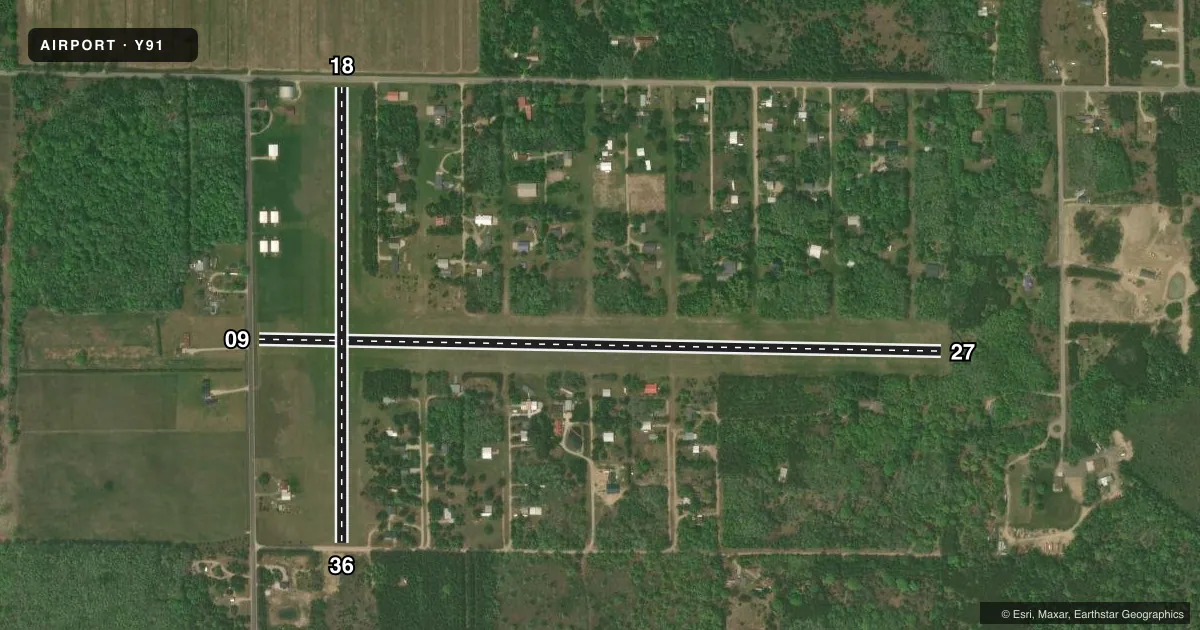
Runways & pattern
Full pagePattern entry · RWY 27
LEFT TRAFFIC| Runway | Heading (°M) | Length | Surface | Traffic |
|---|---|---|---|---|
| 09/27Favored | 86° / 266° | 3,830 ft | TURF | Standard L |
| 18/36 | 175° / 355° | 2,550 ft | TURF | Standard L |
Runway end performance
| End | TORA | TODA | ASDA | LDA | VGSI | Approach lights | Obstruction |
|---|---|---|---|---|---|---|---|
| 09 | — | — | — | — | — | — | 15', road, 46' from thr, 130' R of cntrln, slope 3 |
| 27 | — | — | — | — | — | — | 65', trees, 55' from thr, 80' R of cntrln, slope 0 |
| 18 | — | — | — | — | — | — | 15', road, 43' from thr, 129' R of cntrln, slope 2 |
| 36 | — | — | — | — | — | — | 68', trees, 556' from thr, 150' R of cntrln, slope 8 |
Declared distances in feet. TORA = takeoff run available, TODA = takeoff distance, ASDA = accelerate-stop, LDA = landing distance.
Airport sketch
Runways drawn to scale from FAA survey coordinates, rendered over satellite imagery. Not for navigation.
Approaches & charts
Services on the field
Fuel grades, oxygen, maintenance, ramp storage and lighting — as declared to the FAA by the airport operator.
Fuel & services
- Fuel
- Not available
- Airframe repair
- Not available
- Power plant repair
- Not available
Ramp & ground
- Transient storage
- Tie-down
- Hangar
- Landing fee
- No fee published
- Customs
- Not available
- Lighting schedule
- SEE RMK
- Beacon schedule
- SS-SR
- Beacon
- White / Green (civil land)(WG)
- Wind indicator
- Yes
- Segmented circle
- Yes
Fuel & FBOs
Cheapest 100LL and Jet A on the field and nearby. Always confirm with the FBO before taxi.
Airport notes
Surface conditions, obstructions, local procedures, lighting outages and other notes published with each FAA cycle.
General notes
- NO SNOW REMOVAL - CALL AMGR FOR FLD CONDS.
- DEER & BIRDS ON & INVOF ARPT.
- TALL TREES ALG & AT THE INT OF RWY 09/27 & 18/36 OBSTG VIEW OF ADJ RWY.
- UAS OPR NW CORNER OF ARPT.
- FOR CD CTC MINNEAPOLIS ARTCC AT 651-463-5588.
Lighting notes
- ACTVT LIRL RWY 09/27 & 18/36 - CTAF.
Approach & departure obstructions
- 09RWY & DTHR MKD WITH 3 FT YELLOW CONES.
- 18RWY & DTHR MKD WITH 3 FT YELLOW CONES.
- 27RWY & DTHR MKD WITH 3 FT YELLOW CONES.
- 36RWY & DTHR MKD WITH 3 FT YELLOW CONES.
- 09APCH RATIO 14:1 TO DTHR OVR 68 FT TREES, 952 FT DIST, 150 FT L.
- 18APCH RATIO 0:1 TO DTHR OVR 65 FT TREES, 0 FT DIST, 120 FT L.
- 27APCH RATIO 7:1 TO DTHR OVR 85 FT TREE, 670 FT DIST, 192 FT L.
- 36APCH RATIO 3:1 TO DTHR OVR 41 FT TREES, 130 FT DIST, 135 FT R.
Other notes
- UNMON.
- MANAGERASST AMGR MITCH TUCKER 231-878-2695.
VFR map & nearby airports
VFR sectional. Tap any ICAO chip to open that airport.
Key facts · Y91
Answer card- ICAO
- Y91
- Name
- HOME ACRES SKY RANCH
- Location
- LAKE CITY, MICHIGAN
- Elevation
- 1,246 ft MSL
- Traffic pattern altitude
- 2,046 ft MSL (800 AGL)
- Control tower
- Non-towered (use CTAF)
- Total runways
- 2
- Longest runway
- 09/27 · 3,830 ft
- Published ILS approaches
- 0
- Published frequencies
- 2
- Magnetic variation
- 5°
- Current flight rules
- VFR
- Current wind
- 230° at 12 kt
- Favored runway now
- RWY 27
Home Acres Sky Ranch is in Lake City, Michigan. The field elevation is 1,246 ft MSL. It has two turf runways. The longest is runway 09/27 at 3,830 ft. Runway 18/36 is 2,550 ft. There is no control tower. Pattern altitude is 800 ft AGL, which puts the pattern at 2,046 ft MSL.
No ILS approaches are published here. CTAF is 123.0. UNICOM is also 123.0. The published remarks say UNICOM is unmonitored. Low intensity runway lights for both runways are activated on CTAF. The airport has no on-field FBOs listed, so plan on confirming services with the airport operator before you go.
A first-time pilot should pay close attention to the published runway notes. There are displaced threshold markings with 3 foot yellow cones. The remarks also call out tree obstructions on the approaches to 09, 27 and 36. This is a turf field with no snow removal, so field conditions matter. Call the airport manager before arrival if you need current surface information. For clearance delivery, the Chart Supplement lists Minneapolis ARTCC. Keep the published pattern altitude in mind. The field sits well above sea level for a Michigan strip, so performance planning should be part of the brief.