METAR & TAF 9C8
9C8 does not publish a METAR.
Showing the nearest reporting station: KRQB (ROBEN-HOOD) · 14.1 NM away. Conditions at 9C8 may differ.
METAR · KRQB
Observed 18:55Z
KRQB 271855Z AUTO 24011KT 7SM -RA FEW070 OVC100 21/20 A2981 RMK AO2 PRESFR P0009
- Wind
- 240° @ 11 kt
- Visibility
- 7 SM
- Temp / Dew
- 21°C / 20°C
- Altimeter
- 29.81 inHg
- Clouds
- OVC
- Density alt
- 2,121 ft
- Ceiling
- 10,000 ft AGL
- Rules
- VFR
Airport info & contacts
Manager on record, flight service, ARTCC, attendance schedule and pattern altitude — published by the FAA and refreshed every 28 days.
Location
- From city
- 1 NM SW
- VFR sectional
- CHICAGO
- ARTCC
- ZMP · MINNEAPOLIS
- NOTAM facility
- LAN (NOTAM-D)
Airport manager
- Name
- DON DUNCAN
- Phone
- 231-372-0010
- Address
- 200 S MAIN ST, EVART MI 49631-9700
Flight service · Hours
- FSS LAN
- LANSING1-800-WX-BRIEF
- Attendance
- Unattended
Frequencies
Tap any row to copy the frequency to your clipboard.
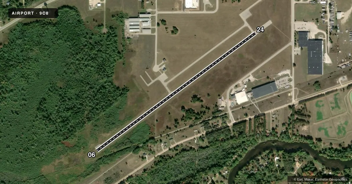
Runways & pattern
Full pagePattern entry · RWY 24
LEFT TRAFFICRunway end performance
| End | TORA | TODA | ASDA | LDA | VGSI | Approach lights | Obstruction |
|---|---|---|---|---|---|---|---|
| 06 | — | — | — | — | PAPI 2-box left(3°) | — | — |
| 24 | — | — | — | — | PAPI 2-box left(3°) | — | — |
Declared distances in feet. TORA = takeoff run available, TODA = takeoff distance, ASDA = accelerate-stop, LDA = landing distance.
Airport sketch
Runways drawn to scale from FAA survey coordinates, rendered over satellite imagery. Not for navigation.
Approaches & charts
Services on the field
Fuel grades, oxygen, maintenance, ramp storage and lighting — as declared to the FAA by the airport operator.
Fuel & services
- Fuel
- Not available
Ramp & ground
- Transient storage
- Tie-down
- Landing fee
- No fee published
- Customs
- Not available
- Lighting schedule
- SEE RMK
- Wind indicator
- Lighted
- Segmented circle
- Yes
Fuel & FBOs
Cheapest 100LL and Jet A on the field and nearby. Always confirm with the FBO before taxi.
Airport notes
Surface conditions, obstructions, local procedures, lighting outages and other notes published with each FAA cycle.
General notes
- TRML BLDG SOUTH DOOR ACES: 5-3-2-1-*.
- FOR CD CTC MINNEAPOLIS ARTCC AT 651-463-5588.
- DEER & LRG BIRDS ON & INVOF ARPT.
Lighting notes
- ACTVT REIL RWY 06 & 24; PAPI RWY 06 & 24; MIRL RWY 06/24 - CTAF.
Other notes
- ASP ANALYSIS DTRMN PENDING.
- MANAGERARPT PHYS ADS: 5814 100TH AVE, EVART, MI 49631.
VFR map & nearby airports
VFR sectional. Tap any ICAO chip to open that airport.
Key facts · 9C8
Answer card- ICAO
- 9C8
- Name
- EVART MUNI
- Location
- EVART, MICHIGAN
- Elevation
- 1,019.9 ft MSL
- Traffic pattern altitude
- 2,019.9 ft MSL (1,000 AGL)
- Control tower
- Non-towered (use CTAF)
- Total runways
- 1
- Longest runway
- 06/24 · 3,804 ft
- Published ILS approaches
- 0
- Published frequencies
- 1
- Magnetic variation
- 4°
- Current flight rules
- VFR
- Current wind
- 240° at 11 kt
- Favored runway now
- RWY 24
Evart Muni is in Evart, Michigan. The field elevation is 1,019.9 ft MSL. It has one runway. Runway 06/24 is 3,804 ft long with an asphalt surface. There is no control tower, so operations are CTAF based on 122.9. No ILS approaches are published here.
The pattern altitude is not published. Use the standard 1,000 ft AGL for light piston traffic unless the current Chart Supplement says otherwise. That puts the traffic pattern at about 2,020 ft MSL based on the listed field elevation. Runway 06 and 24 have runway end identifier lights, PAPI and medium intensity runway lights that are controlled by CTAF. That helps after sunset. You still need to confirm the lighting activation before you go.
No on-field FBOs are listed, so plan on verifying fuel and services with the airport operator or the FBO directly by phone before arrival. Published remarks also note deer and large birds in and near the airport. That matters here. Keep a sharp scan on short final and in the pattern. Clearance delivery for IFR flight is handled through Minneapolis ARTCC at 651-463-5588. The airport analysis determination is still pending. Check the current Chart Supplement for the latest operational notes before you fly in.