METAR & TAF KFFX
Current METAR
Observed 18:15Z
KFFX 271815Z AUTO 19005G15KT 2 1/2SM +RA BR SCT008 BKN012 BKN050 23/23 A2986 RMK AO2 PRESRR
- Wind
- 190° @ 5G15 kt
- Visibility
- 0.5 SM
- Temp / Dew
- 23°C / 23°C
- Altimeter
- 29.86 inHg
- Clouds
- BKN
- Density alt
- 1,991 ft
- Ceiling
- 1,200 ft AGL
- Rules
- LIFR
Airport info & contacts
Manager on record, flight service, ARTCC, attendance schedule and pattern altitude — published by the FAA and refreshed every 28 days.
Location
- From city
- 3 NM SW
- VFR sectional
- CHICAGO
- ARTCC
- ZAU · CHICAGO
- NOTAM facility
- FFX (NOTAM-D)
Airport manager
- Name
- LORI LAYNE
- Phone
- 231-924-7080
- Address
- 7756 W 60TH ST, FREMONT MI 49412-8128
Flight service · Hours
- FSS LAN
- LANSING1-800-WX-BRIEF
- Attendance
- MON-FRI · 0800-1700
- SAT-SUN · ON CALL
Frequencies
Tap any row to copy the frequency to your clipboard.
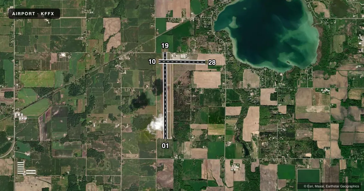
Runways & pattern
Full pagePattern entry · RWY 19
LEFT TRAFFIC| Runway | Heading (°M) | Length | Surface | Traffic |
|---|---|---|---|---|
| 01/19Favored | 356° / 176° | 6,501 ft | ASPH | Standard L |
| 10/28 | 87° / 267° | 3,502 ft | ASPH | Standard L |
Runway end performance
| End | TORA | TODA | ASDA | LDA | VGSI | Approach lights | Obstruction |
|---|---|---|---|---|---|---|---|
| 01 | — | — | — | — | VASI 2-box left(3°) | — | 50', tree, 1850' from thr, 452' R of cntrln, slope 33 |
| 19 | — | — | — | — | PAPI 4-box left(3°) | — | 40', trees, 1285' from thr, 379' R of cntrln, slope 27 |
| 28 | — | — | — | — | PAPI 4-box left(3.5°) | — | — |
Declared distances in feet. TORA = takeoff run available, TODA = takeoff distance, ASDA = accelerate-stop, LDA = landing distance.
Airport sketch
Runways drawn to scale from FAA survey coordinates, rendered over satellite imagery. Not for navigation.
Approaches & charts
Services on the field
Fuel grades, oxygen, maintenance, ramp storage and lighting — as declared to the FAA by the airport operator.
Fuel & services
- Fuel
- 100LLAA+
- Oxygen (bottled)
- Not available
- Oxygen (bulk)
- Not available
- Airframe repair
- Major
- Power plant repair
- Major
- Other services
- AMB
Ramp & ground
- Transient storage
- Tie-down
- Hangar
- Landing fee
- Yes
- Customs
- Not available
- Lighting schedule
- SEE RMK
- Beacon schedule
- SS-SR
- Beacon
- White / Green (civil land)(WG)
- Wind indicator
- Lighted
- Segmented circle
- Yes
Fuel & FBOs
Cheapest 100LL and Jet A on the field and nearby. Always confirm with the FBO before taxi.
Airport notes
Surface conditions, obstructions, local procedures, lighting outages and other notes published with each FAA cycle.
General notes
- SEAPLANE ACT ON ADJ LAKE 0.5 NM NE OF ARPT.
- TRML BLDG ACES 5-3-2-1.
- FOR CD WHEN GREAT LAKES APCH CLSD CTC CHICAGO ARTCC AT 630-906-8921.
Lighting notes
- ACTVT REIL RWY 01 & 19; PAPI RWY 19 & 28; VASI RWY 01; MIRL RWY 01/19 & 10/28 - CTAF.
Fuel notes
- 100LL100LL AVBL SELF SVC.
- AJET A AVBL FULL SVC VIA TRUCK DLVY.
- A+ICING INHIBITOR AVBL UPON REQ.
Runway surface & condition
- 01/19PCR VALUE: 320/F/C/X/T
Approach & departure obstructions
- 288 FT WINDSOCK, 0 FT DIST, 125 FT L.
- 19ALSO 39 FT MKD PLINE, 1500 FT DIST.
Other notes
- 2FOR SVC AFT HRS CALL 616-570-2767.
- AMBOPRD BY GERBER HOSPITAL.
VFR map & nearby airports
VFR sectional. Tap any ICAO chip to open that airport.
Key facts · KFFX
Answer card- ICAO
- KFFX
- Name
- FREMONT MUNI
- Location
- FREMONT, MICHIGAN
- Elevation
- 771.6 ft MSL
- Traffic pattern altitude
- 1,771.6 ft MSL (1,000 AGL)
- Control tower
- Non-towered (use CTAF)
- Total runways
- 2
- Longest runway
- 01/19 · 6,501 ft
- Published ILS approaches
- 0
- Published frequencies
- 5
- Magnetic variation
- 4°
- Current flight rules
- LIFR
- Current wind
- 190° at 5 kt
- Favored runway now
- RWY 19
Fremont Muni is in Fremont, Michigan. The field elevation is 771.6 ft MSL. It has two asphalt runways. The longest is runway 01/19 at 6,501 ft. There is no control tower. Pattern altitude is not published, so use the standard 1,000 ft AGL for light piston traffic unless the current Chart Supplement says otherwise.
No ILS approaches are published here. Runway lighting is pilot controlled on CTAF. Runway end identifier lights are on 01 and 19. PAPI is on 19 and 28. VASI is on 01. That helps at night or in marginal VFR, but you still need to brief the field before arrival.
Heritage Flight Support is on the field. It carries 100LL and Jet A. 100LL is self-serve. Jet A is full service by truck. Icing inhibitor is available on request. If you need service after hours, the published remarks give a phone number for that.
A first-time pilot should also note the nearby seaplane activity on the lake about 0.5 NM northeast of the airport. There is also a marked 39-foot power line about 1,500 ft from runway 19. The pavement classification rating for 01/19 is published as 320/F/C/X/T. Check the current Chart Supplement for any local procedures before you go.