METAR & TAF C04
C04 does not publish a METAR.
Showing the nearest reporting station: KFFX (FREMONT MUNI) · 19.0 NM away. Conditions at C04 may differ.
METAR · KFFX
Observed 15:55Z
KFFX 271555Z AUTO 21007G16KT 10SM SCT100 25/23 A2978 RMK AO2
- Wind
- 210° @ 7G16 kt
- Visibility
- 10 SM
- Temp / Dew
- 25°C / 23°C
- Altimeter
- 29.78 inHg
- Clouds
- SCT
- Density alt
- 2,509 ft
- Ceiling
- Unlimited
- Rules
- VFR
Airport info & contacts
Manager on record, flight service, ARTCC, attendance schedule and pattern altitude — published by the FAA and refreshed every 28 days.
Location
- From city
- 4 NM SE
- VFR sectional
- CHICAGO
- ARTCC
- ZAU · CHICAGO
- NOTAM facility
- LAN (NOTAM-D)
Airport manager
- Name
- CURT LOHMAN
- Phone
- 231-861-9910
- Address
- 1805 BASELINE RD, SHELBY MI 49455-9630
Flight service · Hours
- FSS LAN
- LANSING1-800-WX-BRIEF
- Attendance
- IREG
Frequencies
Tap any row to copy the frequency to your clipboard.
Runways & pattern
Full pagePattern entry · RWY 27
LEFT TRAFFIC| Runway | Heading (°M) | Length | Surface | Traffic |
|---|---|---|---|---|
| 09/27Favored | 78° / 258° | 3,500 ft | ASPH | Standard L |
| 15/33 | 138° / 318° | 2,251 ft | TURF | Standard L |
Runway end performance
| End | TORA | TODA | ASDA | LDA | VGSI | Approach lights | Obstruction |
|---|---|---|---|---|---|---|---|
| 09 | — | — | — | — | PAPI 2-box left(4°) | — | 156', trees, 2952' from thr, 605' R of cntrln, slope 17 |
| 27 | — | — | — | — | PAPI 2-box left(4°) | — | 88', trees, 1865' from thr, 496' R of cntrln, slope 18 |
| 15 | — | — | — | — | — | — | 2', road, 0' from thr, 100' R of cntrln, slope 0 |
| 33 | — | — | — | — | — | — | 5', trees, 5' from thr, 100' R of cntrln, slope 1 |
Declared distances in feet. TORA = takeoff run available, TODA = takeoff distance, ASDA = accelerate-stop, LDA = landing distance.
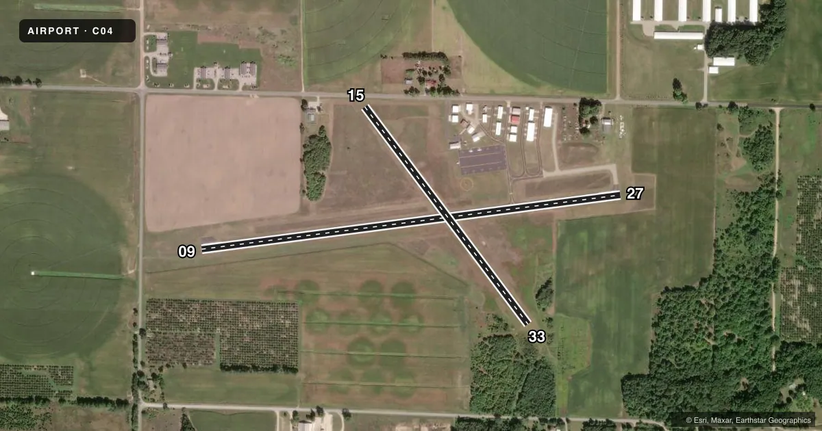
Airport sketch
Runways drawn to scale from FAA survey coordinates, rendered over satellite imagery. Not for navigation.
Approaches & charts
Services on the field
Fuel grades, oxygen, maintenance, ramp storage and lighting — as declared to the FAA by the airport operator.
Fuel & services
- Fuel
- 100LL
- Oxygen (bottled)
- Not available
- Oxygen (bulk)
- Not available
- Airframe repair
- Not available
- Power plant repair
- Not available
- Other services
- AGRI
Ramp & ground
- Transient storage
- Tie-down
- Landing fee
- No fee published
- Customs
- Not available
- Lighting schedule
- SEE RMK
- Wind indicator
- Lighted
- Segmented circle
- Yes
Fuel & FBOs
Cheapest 100LL and Jet A on the field and nearby. Always confirm with the FBO before taxi.
Airport notes
Surface conditions, obstructions, local procedures, lighting outages and other notes published with each FAA cycle.
General notes
- RDO CTL ACFT OPS AT RWY 15 END.
- FOR FICONS CALL 231-861-4272 (AMGR RES) OR 231-742-0142 (CELL).
- ADMIN BLDG ACES: PRESS V, THEN III & II SIMUL, THEN I.
- FOR CD CTC GREAT LAKES APCH AT 269-459-3344, WHEN APCH CLSD CTC CHICAGO ARTCC AT 630-906-8921.
Lighting notes
- ACTVT PAPI RWY 09 & 27; MIRL RWY 09/27 - CTAF.
Fuel notes
- 100LLAVBL H24 SELF SVC.
Approach & departure obstructions
- 15RWY & DTHR MKD WITH 3 FT YELLOW CONES.
- 33RWY & DTHR MKD WITH 3 FT YELLOW CONES.
- 15CTLG OBSTN EXCEEDS A 45 DEG SLP. APCH RATIO 20:1 TO DTHR.
- 33APCH RATIO 11:1 TO DTHR OVR +99 FT TREE, 1145 FT DIST, 200 FT R.
Other notes
- RPRS ON CALL 231-861-2210 OR 231-730-6644.
- ESTABD BFR 1959.
- MANAGERCELL 231-742-0142.
- 15/33ROUGH & SOFT WHEN WET.
VFR map & nearby airports
VFR sectional. Tap any ICAO chip to open that airport.
Key facts · C04
Answer card- ICAO
- C04
- Name
- OCEANA COUNTY
- Location
- HART/SHELBY, MICHIGAN
- Elevation
- 915.8 ft MSL
- Traffic pattern altitude
- 1,915.8 ft MSL (1,000 AGL)
- Control tower
- Non-towered (use CTAF)
- Total runways
- 2
- Longest runway
- 09/27 · 3,500 ft
- Published ILS approaches
- 0
- Published frequencies
- 4
- Magnetic variation
- 5°
- Current flight rules
- VFR
- Current wind
- 210° at 7 kt
- Favored runway now
- RWY 27
Oceana County Airport sits in Hart/Shelby, Michigan. The field elevation is 915.8 ft MSL. It has two runways. The longest is 09/27 at 3,500 ft asphalt. Runway 15/33 is 2,251 ft turf. There is no control tower. CTAF and UNICOM are both 122.7. Great Lakes Approach handles APCH and DEP on 119.8 and 290.35. No ILS approaches are published.
For pattern work, the published pattern altitude is not listed. Use the standard 1,000 ft AGL for light piston operations unless the current Chart Supplement says otherwise. The on-field FBO is Oceana County Airport. It carries 100LL. Call ahead at (231) 861-9910 for current service details.
A few remarks matter here. Runway 09 and 27 have medium intensity lights controlled by CTAF. The PAPI is activated for those runways. Runway 15 has a cataloged obstruction issue on approach. Runway 33 has a displaced threshold with a nearby tree on the approach path. Runways 15 and 33 are rough and soft when wet. If you need clearance delivery, contact Great Lakes Approach. If approach is closed, use Chicago ARTCC. First-time visitors should brief the lighting setup. Brief the displaced threshold on 33. Brief the turf condition on 15/33 before arrival.