METAR & TAF 7D3
7D3 does not publish a METAR.
Showing the nearest reporting station: KRQB (ROBEN-HOOD) · 17.2 NM away. Conditions at 7D3 may differ.
METAR · KRQB
Observed 15:15Z
KRQB 271515Z AUTO 24007KT 10SM FEW120 25/18 A2977 RMK AO2 PRESFR
- Wind
- 240° @ 7 kt
- Visibility
- 10 SM
- Temp / Dew
- 25°C / 18°C
- Altimeter
- 29.77 inHg
- Clouds
- FEW
- Density alt
- 2,413 ft
- Ceiling
- Unlimited
- Rules
- VFR
Airport info & contacts
Manager on record, flight service, ARTCC, attendance schedule and pattern altitude — published by the FAA and refreshed every 28 days.
Location
- From city
- 2 NM S
- VFR sectional
- CHICAGO
- ARTCC
- ZMP · MINNEAPOLIS
- NOTAM facility
- LAN (NOTAM-D)
Airport manager
- Name
- MAC L MCCLELLAN
- Phone
- 231-745-7815
- Address
- 7668 S M-37, BALDWIN MI 49304
Flight service · Hours
- FSS LAN
- LANSING1-800-WX-BRIEF
- Attendance
- Unattended
Frequencies
Tap any row to copy the frequency to your clipboard.
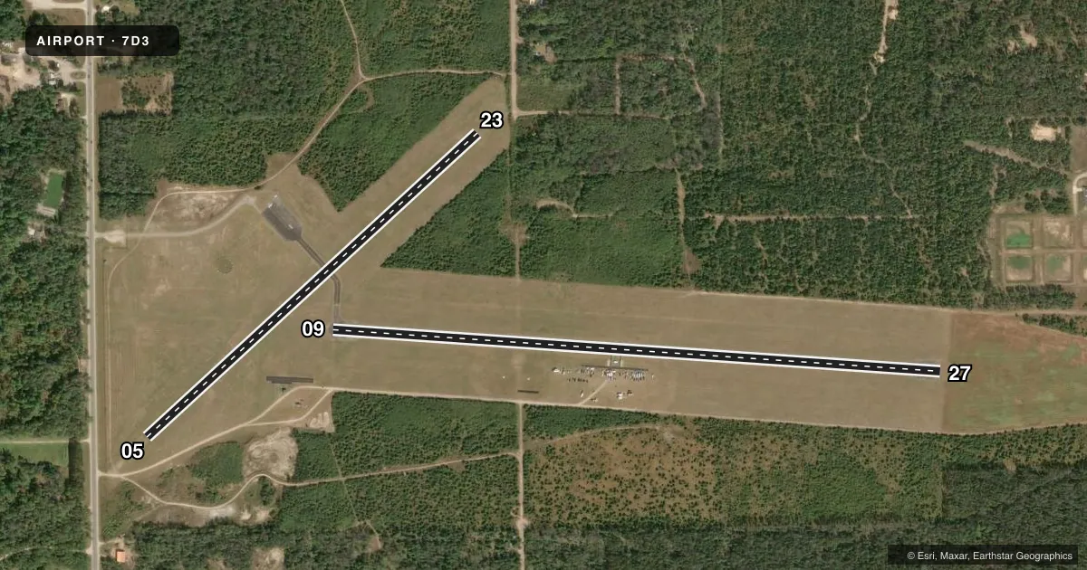
Runways & pattern
Full pagePattern entry · RWY 23
LEFT TRAFFIC| Runway | Heading (°M) | Length | Surface | Traffic |
|---|---|---|---|---|
| 09/27 | 88° / 268° | 3,800 ft | ASPH | Standard L |
| 05/23Favored | 41° / 221° | 2,800 ft | TURF | Standard L |
Runway end performance
| End | TORA | TODA | ASDA | LDA | VGSI | Approach lights | Obstruction |
|---|---|---|---|---|---|---|---|
| 27 | — | — | — | — | — | — | 80', trees, 1382' from thr, 300' R of cntrln, slope 14 |
| 05 | — | — | — | — | — | — | 63', trees, 470' from thr, 140' R of cntrln, slope 7 |
| 23 | — | — | — | — | — | — | 15', road, 267' from thr, 77' R of cntrln, slope 17 |
Declared distances in feet. TORA = takeoff run available, TODA = takeoff distance, ASDA = accelerate-stop, LDA = landing distance.
Airport sketch
Runways drawn to scale from FAA survey coordinates, rendered over satellite imagery. Not for navigation.
Approaches & charts
Services on the field
Fuel grades, oxygen, maintenance, ramp storage and lighting — as declared to the FAA by the airport operator.
Fuel & services
- Fuel
- Not available
- Oxygen (bottled)
- Not available
- Oxygen (bulk)
- Not available
- Airframe repair
- Not available
- Power plant repair
- Not available
Ramp & ground
- Transient storage
- Tie-down
- Landing fee
- No fee published
- Customs
- Not available
- Wind indicator
- Yes
- Segmented circle
- Yes
Fuel & FBOs
Cheapest 100LL and Jet A on the field and nearby. Always confirm with the FBO before taxi.
Airport notes
Surface conditions, obstructions, local procedures, lighting outages and other notes published with each FAA cycle.
General notes
- DEER ON & INVOF ARPT.
- UAS OPS ADJ TO RWY 09/27.
- GATE 5-3-2-1.
- FOR CD CTC MINNEAPOLIS ARTCC AT 651-463-5588.
- ARPT CLSD WHEN SNOW COVD - NO SNOW REMOVAL.
Approach & departure obstructions
- 05RWY & DTHR MKD WITH 3 FT YELLOW CONES.
- 23RWY & DTHR MKD WITH 3 FT YELLOW CONES.
Other notes
- THIS AIRPORT HAS BEEN SURVEYED BY THE NATIONAL GEODETIC SURVEY.
- PILOTS MUST SUP ROPES.
- MANAGERCELL 231-250-2551.
VFR map & nearby airports
VFR sectional. Tap any ICAO chip to open that airport.
Key facts · 7D3
Answer card- ICAO
- 7D3
- Name
- BALDWIN MUNI
- Location
- BALDWIN, MICHIGAN
- Elevation
- 828 ft MSL
- Traffic pattern altitude
- 1,828 ft MSL (1,000 AGL)
- Control tower
- Non-towered (use CTAF)
- Total runways
- 2
- Longest runway
- 09/27 · 3,800 ft
- Published ILS approaches
- 0
- Published frequencies
- 1
- Magnetic variation
- 6°
- Current flight rules
- VFR
- Current wind
- 240° at 7 kt
- Favored runway now
- RWY 23
Baldwin Muni sits in Baldwin, Michigan. The field elevation is 828 ft MSL. It has two runways. The longest is 3,800 ft asphalt runway 09/27. Runway 05/23 is 2,800 ft turf. There is no control tower. CTAF is 122.9. No ILS approaches are published here.
Pattern altitude is not published. Use the standard 1,000 ft AGL pattern unless local procedures say otherwise. That puts the light-piston pattern at 1,828 ft MSL. This is a good field to brief carefully before arrival. Deer are reported on and near the airport. Snow can also shut the airport down because no snow removal is provided. The runway 05 and runway 23 thresholds are marked with 3 foot yellow cones. Runway 05/23 is also noted with displaced threshold markings.
There are no on-field FBOs listed in the facts. Check with the airport operator or call the field on CTAF for current services before you go. For clearance delivery, Minneapolis ARTCC is listed in the remarks at 651-463-5588. Pilots should also note that unmanned aircraft system operations are adjacent to runway 09/27. That makes a careful traffic scan important on both arrival and departure.